
Mobile Bay is a shallow inlet of the Gulf of Mexico, lying within the state of Alabama in the United States. Its mouth is formed by the Fort Morgan Peninsula on the eastern side and Dauphin Island, a barrier island on the western side. The Mobile River and Tensaw River empty into the northern end of the bay, making it an estuary. Several smaller rivers also empty into the bay: Dog River, Deer River, and Fowl River on the western side of the bay, and Fish River on the eastern side. Mobile Bay is the fourth largest estuary in the United States with a discharge of 62,000 cubic feet (1,800 m3) of water per second. Annually, and often several times during the summer months, the fish and crustaceans will swarm the shallow coastline and shore of the bay. This event, appropriately named a jubilee, draws a large crowd because of the abundance of fresh, easily caught seafood.

Baldwin County is a county located in the southwestern part of the U.S. state of Alabama, on the Gulf coast. According to the 2019 estimates from the U.S. Census Bureau, the population is approximately 223,234. The county seat is Bay Minette. The county is named in honor of Senator Abraham Baldwin, though he never lived in what is now Alabama.
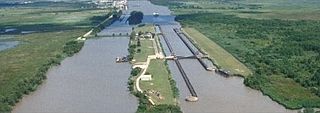
The Gulf Intracoastal Waterway is the portion of the Intracoastal Waterway located along the Gulf Coast of the United States. It is a navigable inland waterway running approximately 1,050 mi (1,690 km) from Carrabelle, Florida, to Brownsville, Texas.

The Mobile River is located in southern Alabama in the United States. Formed out of the confluence of the Tombigbee and Alabama rivers, the approximately 45-mile-long (72 km) river drains an area of 44,000 square miles (110,000 km2) of Alabama, with a watershed extending into Mississippi, Georgia, and Tennessee. Its drainage basin is the fourth-largest of primary stream drainage basins entirely in the United States. The river has historically provided the principal navigational access for Alabama. Since construction of the Tennessee-Tombigbee Waterway, it also provides an alternative route into the Ohio River watershed.

The Battle of Mobile Bay of August 5, 1864, was an engagement of the American Civil War in which a Union fleet commanded by Rear Admiral David G. Farragut, assisted by a contingent of soldiers, attacked a smaller Confederate fleet led by Admiral Franklin Buchanan and three forts that guarded the entrance to Mobile Bay. Farragut's order of "Damn the torpedoes! Four bells. Captain Drayton, go ahead! Jouett, full speed!" became famous in paraphrase, as "Damn the torpedoes, full speed ahead!"

The Dog River is a river in Mobile County, Alabama. The Dog River watershed drains more than 90 square miles (230 km2). The river is about 8 miles (13 km) long and is influenced by tides. It originates at 30.64158°N 88.09666°W within the city of Mobile. It discharges into Mobile Bay, a tidal estuary on the northern Gulf of Mexico, at 30.56491°N 88.08833°W near Hollinger's Island. It was named by the original French colonists as the Riviere Au Chien, which can be translated into English as Dog River.

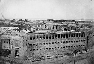
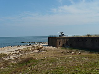
Fort Morgan is a historic masonry pentagonal bastion fort at the mouth of Mobile Bay, Alabama, United States. Named for Revolutionary War hero Daniel Morgan, it was built on the site of the earlier Fort Bowyer, an earthen and stockade type fortification involved in the final land battles of the War of 1812. Construction was completed in 1834 and it received its first garrison in March of the same year.
Eastern Shore is the geographic eastern shoreline of Mobile Bay in southwest Alabama. It extends from just north of Interstate 10 to the southeastern end of the bay near Weeks Bay. Since there is no official boundary set for the "Eastern Shore" its usage is subject to change. However, broadly speaking, the area is bounded by U.S. Highway 31 to the north, U.S. Highway 98 to the south, State Route 181 to the east and Mobile Bay to the west.

Metropolitan Mobile has a population of 412,992 within Mobile County Alabama in the southwestern tip of Alabama. The Mobile metropolitan area is the third-largest metropolitan area in the state of Alabama.
The Siege of Fort Morgan occurred during the American Civil War, as part of the battle for Mobile Bay, in Alabama (U.S.), during August 1864. Union ground forces led by General Gordon Granger conducted a short siege of the Confederate garrison at the mouth of Mobile Bay under the command of General Richard L. Page. The Confederate surrender helped shut down Mobile, Alabama, as an effective Confederate port city.
The Siege of Fort Gaines occurred between August 3 and 8, 1864, during the American Civil War. It took place in the Mobile Bay area of Alabama as part of the larger battle of Mobile Bay, and resulted in the surrender of the fort and its defenders.

Bon Secour is an unincorporated community in Baldwin County, Alabama, United States. It lies along the eastern coastline of Bon Secour Bay. Bon Secour is over 35 miles (56 km) due east of the Alabama–Mississippi state line, near Gulf Shores, and over 45 miles (72 km) west of Pensacola, Florida. The name "Bon Secour" derives from the French phrase meaning "safe harbor" due to the secluded location on the inside coast of the Fort Morgan peninsula of southern Alabama.

The Mobile Point Range Lights were a series of lighthouses at the entrance to Mobile Bay, at Mobile Point on the tip of the Fort Morgan peninsula, near Mobile, Alabama, United States. The first lighthouse was built as a landfall light by June 1822 at a cost of $9,995. The lighthouse was a conical brick masonry tower, 40 feet (12 m) tall. It was first lit on 29 September 1822. Fort Morgan was built adjacent to the lighthouse in 1833. The lighthouse was joined by the 200-foot (61 m) Sand Island Light across the mouth of the bay, about 3 miles (4.8 km) away in 1858. This resulted in the Mobile Point Lighthouse being downgraded to a harbor light, at the same time a fourth order Fresnel lens was installed. A period photograph, taken prior to the American Civil War, shows two shorter masonry towers standing on the beach below the main tower, they served as range lights. The lighthouse was subsequently destroyed by cannonball fire in the Battle of Mobile Bay during the Civil War.

Fort Morgan, also known as Fort Bowyer, is an unincorporated community in Baldwin County, Alabama, United States. It is west of Gulf Shores on Mobile Point. Mobile Point extends from Gulf Shores to the west, towards historic Fort Morgan at the tip of the peninsula.
USS Glasgow (1863) was a blockade runner captured by the Union Navy during the American Civil War. She was used by the Union Navy principally as a dispatch boat and storeship in support of the blockade of the ports of the Confederate States of America.

USS Rodolph (1863) was a steamer commissioned by the Union Navy during the American Civil War.
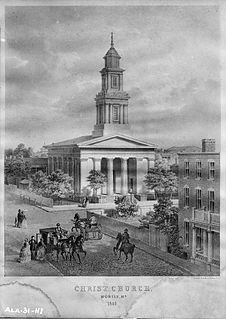
Christ Church Cathedral, also known simply as Christ Church, is a historic Episcopal cathedral located in Mobile, Alabama, USA.

1st Regiment Indiana Heavy Artillery was a heavy artillery regiment that served in the Union Army during the American Civil War. It was nicknamed the "Jackass Regiment". Before being converted into an artillery unit in 1863, it served as the 21st Regiment, Indiana Volunteer Infantry.
The Tombigbee District, also known as the Tombigbee, was one of two areas, the other being the Natchez District, that were the first in what was West Florida to be colonized by British subjects from the Thirteen Colonies and elsewhere. This later became the Mississippi Territory as part of the United States. The district was also the first area to be opened to white settlement in what would become the state of Alabama, outside of the French colonial outpost of Mobile on the Gulf Coast. The Tombigbee and Natchez districts were the only areas populated by whites in the Mississippi Territory when it was formed by the United States in 1798.
The Milwaukee-class monitors were a class of four riverine ironclad monitors built during the American Civil War. Several supported Union forces along the Mississippi River in mid-1864 before participating in the Battle of Mobile Bay in August. Chickasaw and Winnebago bombarded Confederate coastal fortifications during the battle and during subsequent operations as well as engaging the ironclad Tennessee II. The other two ships arrived at Mobile Bay after the battle and all four supported the land attacks on Mobile in March–April 1865. Milwaukee struck a torpedo during this time and sank. The surviving three ships were sold in 1874; Chickasaw was converted into a ferry and survived until 1944 when she was scuttled. Her wreck was discovered in 2004.