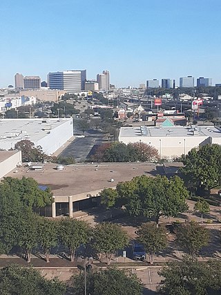
Park Lane is a DART Light Rail station in northern Dallas, Texas. The elevated station is located at the intersection of Park Lane and Greenville Avenue, about 0.2 miles (0.32 km) east of North Central Expressway (US 75). The station serves the Red Line and Orange Line.

Lovers Lane station is a DART Light Rail station in Dallas, Texas. It serves the Red Line and Orange Line. The station is located in East Dallas; it is directly east of North Central Expressway (US 75) and one block south of the intersection of Lovers Lane and Greenville Avenue.

SMU/Mockingbird station is a DART Light Rail station in Dallas, Texas. The station is located at the intersection of Mockingbird Lane and North Central Expressway (US 75). The station serves the Red Line, Orange Line, and Blue Line. It is the northernmost station to serve all three lines: the Red and Orange Lines continue north towards Richardson and Plano, while the Blue Line continues northeast towards Garland and Rowlett.

State Highway 121 is a state highway angling from southwest to northeast through north central Texas. It runs from Cleburne, Texas at US 67 to SH 78 in Bonham, Texas, just north of a junction with US 82.

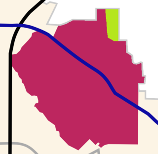
Oak Lawn is a neighborhood in Dallas, Texas, defined in Dallas City Ordinance 21859 as Planned Development District No. 193, the Oak Lawn Special Purpose DistrictArchived 2011-07-08 at the Wayback Machine. The unofficial boundaries are Turtle Creek Boulevard, Central Expressway, the City of Highland Park, Inwood Road, and Harry Hines Boulevard. It is over 12 square miles (31 km2) in area. Officially it is bounded by the City of Highland Park, the North Central Expressway, Stemmons Freeway, Woodall Rodgers Freeway, and other roads. The district is within the boundary defined by the City of Dallas law, excluding any existing planned development districts within.

Loop 12 is a state highway that runs mostly within the city limits of Dallas, Texas. The western segment of the loop is named after General Walton Walker, who served and died in South Korea. During the 1950s and 1960s, Loop 12 was the outer beltway in the Dallas area, having since been supplanted by I-635, which is itself being supplanted by the President George Bush Turnpike. Loop 12 is, however, the only state highway in Dallas that forms a complete loop.

The Dallas North Tollway is a 30.2-mile (49 km) controlled-access toll road operated by the North Texas Tollway Authority (NTTA), which runs from Interstate 35E near Downtown Dallas, Texas (USA), to U.S. Highway 380, in Frisco, Texas. On December 20, 2023, the NTTA announced the Tollway's next extension which runs 6 miles (9.7 km) through Prosper and Celina and ends at FM 428.

Interstate 635 (I-635) is a 37-mile-long (60 km) partial loop around Dallas, Texas, in the United States between I-20 in Balch Springs and SH 121 at the north entrance of the DFW Airport in Grapevine. It intersects I-35E at exits 27B and 27C but does not connect with I-35W. I-635 and a part of I-20 are collectively designated as the Lyndon B. Johnson Freeway; known locally as the LBJ Freeway, or simply LBJ. The roadway is named after Lyndon B. Johnson, the former U.S. senator from Texas and the 37th vice-president and 36th president of the U.S. Where I-635 ends at I-20, I-20 continues the LBJ Freeway designation heading west. Since the portion of I-20 between Spur 408 to I-635 retains the same names as I-635, the two highways are considered three-quarters of the beltway around Dallas. Together with Spur 408, a portion of Loop 12, and a portion of I-35E, I-635 and I-20 complete the beltway.

The Orange Line is a 37-mile (60 km) light rail line in the Dallas, Texas metropolitan area. The line is operated by Dallas Area Rapid Transit as a part of its DART Light Rail system. It is the only east-west line in the system.
Central Expressway is a north–south highway in the Dallas-Fort Worth Metroplex in Texas (USA) and surrounding areas. The best-known section is the North Central Expressway, a name for a freeway section of U.S. Highway 75 between downtown Dallas and Van Alstyne, Texas. The southern terminus is south of the Woodall Rodgers Freeway at exit 284C of "hidden" Interstate 345. From there, Central Expressway becomes the South Central Expressway, the northernmost portion of which was renamed César Chávez Boulevard on April 9, 2010.
This article is about transportation systems in and around Dallas, Texas (USA).
Lower Greenville is a neighborhood in east Dallas, Texas (USA), west of Lakewood. Specifically, the neighborhood is the area adjacent to Greenville Avenue south of Mercedes Avenue and north of Belmont Avenue. The area south of Belmont Avenue is often, and more specifically, called "Lowest Greenville," and the area north of Mockingbird Lane is called "Upper Greenville." "Lower Greenville" is also used to refer to the neighborhoods surrounding Greenville Avenue, including Vickery Place, the Belmont Addition, Glencoe, Greenland Hills, and Stonewall Terrace. It straddles Dallas Council Districts 14 and 2.
Greenland Hills is a neighborhood in east Dallas, Texas, United States. It is bounded on the west by North Central Expressway, on the south by Vanderbilt Avenue, on the east by Greenville Avenue and on the north by McCommas Boulevard.

Interstate 35 (I-35) is a major north–south Interstate Highway that runs from Laredo, Texas near the Mexican border to Duluth, Minnesota. In Texas, the highway begins in Laredo and runs north to the Red River north of Gainesville, where it crosses into Oklahoma. Along its route, it passes through the cities of San Antonio, Austin, and Waco before splitting into two branch routes just north of Hillsboro: I-35E heads northeast through Dallas, while I-35W turns northwest to run through Fort Worth. The two branches rejoin in Denton to again form I-35, which continues to the Oklahoma state line. The exit numbers for I-35E maintain the sequence of exit numbers from the southern segment of I-35, and the northern segment of I-35 follows on from the sequence of exit numbers from I-35E. I-35W maintains its own sequence of exit numbers.
Elm Thicket is a primarily residential neighborhood in North Dallas, Texas near Love Field airport and the neighborhoods of Love Field, Bluffview, Greenway Parks, University Park and Highland Park.
The Sam Rayburn Tollway is a controlled-access toll road operated by the North Texas Tollway Authority that runs from Grapevine to McKinney. Its frontage roads are signed SH 121.

DART Light Rail is the light rail system serving the metropolitan area of Dallas, Texas and is owned and operated by Dallas Area Rapid Transit (DART). The DART Light Rail system opened June 14, 1996 and serves 65 stations and four lines, covering 93 miles (149.7 km): the Blue Line, the Red Line, the Green Line, and the Orange Line.

North Dallas is an area of numerous communities and neighborhoods in Dallas, Texas. The phrase "North Dallas" is also sometimes used to include any suburb or exurb north of Dallas proper within the metropolitan area. The majority of North Dallas is located in Dallas County, while a small portion is located in Collin and Denton counties. North Dallas generally includes areas of Dallas north of Northwest Highway, along with Lake Highlands and areas of Dallas north of IH-635 known as Far North Dallas. The area has strong social and economic ties to the Dallas enclave of Park Cities, and two inner suburbs of Dallas, Richardson and Addison.

Whispering Hills is a neighborhood consisting of 615 homes within the Lake Highlands neighborhood of Dallas, Texas adjacent to the suburbs of Richardson and Garland. It is generally bounded by Buckingham Rd along the Richardson border to the north, to the east by the Garland border near Plano Rd, to the south by Walnut St, and to the west by the KCS Railroad and Audelia Branch Greenbelt near Audelia Rd.
Cedar Springs Road is a road mainly in Uptown Dallas. The road also connects to Dallas Love Field and provides access to its terminal. It also once was a major thoroughfare through central Dallas and the Turtle Creek area in the early 1900s. Dallas Area Rapid Transit bus route 39 traversed much of the length of this road; however, in 2022, bus route 103 replaced it.


