The Trinity River is a 710-mile (1,140 km) river, the longest with a watershed entirely within the U.S. state of Texas. It rises in extreme northern Texas, a few miles south of the Red River. The headwaters are separated by the high bluffs on the southern side of the Red River.

The Broadway Bridge is a Rall-type bascule bridge spanning the Willamette River in Portland, Oregon, United States, built in 1913. It was Portland's first bascule bridge, and it continues to hold the distinction of being the longest span of its bascule design type in the world. It was added to the National Register of Historic Places in November 2012.

The Waco Suspension Bridge crosses the Brazos River in Waco, Texas. It is a single-span suspension bridge, with a main span of 475 ft. Opened on November 20, 1869, it contains nearly 3 million bricks. It is located north of downtown Waco, connecting Indian Spring Park with Doris D. Miller Park. Every year on Independence Day, the bridge serves as a place where thousands of locals gather to watch fireworks. Indian Spring Park marks the location of the origin of the town of Waco, where the Huaco Indians had settled on the bank of the river, at the location of a cold spring.

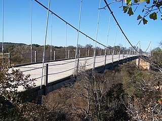
The Regency Bridge, locally known as the "Swinging Bridge," is a one-lane suspension bridge over the Colorado River in Texas. It is located at the intersection of Mills County Road 433 and San Saba County Road 137, both gravel roads, near a small community called Regency. The bridge spans the Colorado River between Mills and San Saba counties.

Oak Lawn is a neighborhood in Dallas, Texas (USA), defined in Dallas City Ordinance 21859 as Planned Development District No. 193, the Oak Lawn Special Purpose District. The unofficial boundaries are Turtle Creek Boulevard, Central Expressway, the City of Highland Park, Inwood Road, and Harry Hines Boulevard. It is over 12 square miles (31 km2) in area. Officially it is bounded by the City of Highland Park, the North Central Expressway, Stemmons Freeway, Woodall Rodgers Freeway, and other roads. The district is within the boundary defined by the City of Dallas law, excluding any existing planned development districts within.

The Rainbow Bridge is a through truss bridge crossing the Neches River in Southeast Texas just upstream from Sabine Lake. It allows State Highway 87 and State Highway 73 to connect Port Arthur in Jefferson County on the southwest bank of the river. Bridge City in Orange County is on the northeast bank.

Spur 366, also named Woodall Rodgers Freeway, is a highway that connects Beckley Avenue and Singleton Boulevard in West Dallas to Interstate 35E and U.S. Highway 75 in central Dallas, Texas. The highway, as part of the downtown freeway loop, also serves as a dividing line between downtown Dallas on the south and the Uptown and Victory Park neighborhoods on the north.
The Trinity River Project is a public works project undertaken in the 2000s in the city of Dallas, Texas, United States. Its goal is to redevelop the Trinity River. The project aims to turn the river's path into a collection of sports fields, trails, nature centers, and recreational opportunities. At 10,000 acres (4,000 ha), it is one of the larger urban parks in the United States.

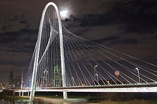
The Margaret Hunt Hill Bridge is a bridge in Dallas, Texas, that spans the Trinity River. The bridge is named for Margaret Hunt Hill, an heiress and philanthropist. The bridge was constructed as part of the Trinity River Project. Designed by Santiago Calatrava, it is one of three such bridges planned to be built over the Trinity; the second, the Margaret McDermott Bridge, is completed; the third cancelled. The span parallels the Ronald Kirk Bridge, a walking bridge that was previously the Continental Avenue bridge.

The Lamar Boulevard Bridge is a historic arch bridge carrying Texas State Highway Loop 343 over Lady Bird Lake in downtown Austin, Texas, United States. The bridge features six open-spandrel concrete arches spanning 659 feet (201 m) and carries tens of thousands of vehicles daily across the lake. Completed in 1942, the Lamar Boulevard Bridge was the second permanent bridge to cross the Colorado River, and one of the last Art Deco-style open-spandrel concrete arch bridges built in Texas. The bridge was named an Austin Landmark in 1993 and added to the National Register of Historic Places in 1994.

U.S. Route 183 (US 183) is a north-south U.S. highway that begins in Texas in Refugio at an intersection with US 77 concurrent with US 77 Alt. The highway runs through many small communities with Austin being the only major city along its route. The highway exits Texas concurrent with US 70, crossing into Oklahoma.

Old Alton Bridge, also known as Goatman's Bridge, is a historic iron truss bridge connecting the Texas cities of Denton and Copper Canyon. Built in 1884 by the King Iron Bridge Manufacturing Company, it originally carried horses and later automobiles over Hickory Creek at a location that once was a popular ford for crossing cattle. The bridge takes its name from the abandoned community of Alton, which between 1850 and 1856 was the seat of Denton County.

Downtown Dallas is the central business district (CBD) of Dallas, Texas, United States, located in the geographic center of the city. It is the second-largest business district in the state of Texas. The area termed "Downtown" has traditionally been defined as bounded by the downtown freeway loop, bounded on the east by I-345 (although known and signed as the northern terminus of I-45 and the southern terminus of US 75, on the west by I-35E, on the south by I-30, and on the north by Woodall Rodgers Freeway.

The Paddock Viaduct, also known as the Main Street Viaduct, is a reinforced concrete bridge spanning the Trinity River in Fort Worth, Texas. Low-water crossings and ferries originally provided the only access across the Trinity River at this location, connecting the downtown area of Fort Worth with northern sections of the city. A two-lane suspension bridge, constructed near this site in the 1890s, proved inadequate for the growing population. This span, designed by the St. Louis engineering firm of Brenneke and Fay, was completed in 1914. It was the first reinforced concrete arch in the nation to use self-supporting, reinforcing steel. The bridge is named in honor of B. B. Paddock, former State Legislator and Mayor of the City (1980).

US 281 Bridge at the Brazos River refers to two bridges located south of Mineral Wells, Texas. They carry U.S. Route 281 (US 281) across the Brazos River.

The Washington Avenue Bridge in Iowa Falls, Iowa is an attractive concrete two-span open spandrel arched bridge that brings Washington Avenue over the Iowa River. Originally it carried US 20. It was built in 1934 by the Weldon Brothers for $51,710.55.

Margaret Hunt Hill (1915–2007) was an American heiress and philanthropist.

The Margaret McDermott Bridge is a conventional concrete pier-and-beam freeway bridge with cable-stayed bike lines over the Trinity River in Dallas, Texas. It replaced the late-1950s to early-1960s Interstate 30 (I-30) bridge, which reached its end of life. It was partially designed by Santiago Calatrava, and is part of the Trinity River Project and the Horseshoe Project. It was named for Margaret McDermott, an area philanthropist.

The Houston Street Viaduct is a viaduct in Dallas, Texas, that carries Houston Street across the Trinity River, connecting Downtown Dallas and Oak Cliff. Designed by Ira G. Hedrick, it was built in 1911, and is listed on the National Register of Historic Places.


