
New South Wales is a state on the east coast of Australia. It borders Queensland to the north, Victoria to the south, and South Australia to the west. Its coast borders the Coral and Tasman Seas to the east. The Australian Capital Territory and Jervis Bay Territory are enclaves within the state. New South Wales' state capital is Sydney, which is also Australia's most populous city. In December 2023, the population of New South Wales was over 8.3 million, making it Australia's most populous state. Almost two-thirds of the state's population, 5.3 million, live in the Greater Sydney area.

Parramatta is a major suburb and commercial district in Greater Western Sydney, located approximately 24 kilometres (15 mi) west of the Sydney CBD, on the banks of the Parramatta River. It is often regarded as the secondary central business district in metropolitan Sydney.

Mascot is an inner south and west suburb of Sydney, in the state of New South Wales, Australia. Mascot is located 7 kilometres south of the Sydney central business district and is one of the administrative centres of the Bayside Council. A small part of Mascot is located in the Inner West Council. Mascot is on the north-west side of Botany Bay and contains Sydney Airport.
Redfern is an inner southern suburb of Sydney located 3 kilometres (1.9 mi) south of the Sydney central business district and is part of the local government area of the City of Sydney. Strawberry Hills is a locality on the border with Surry Hills. The area experienced the process of gentrification and is subject to extensive redevelopment plans by the state government, to increase the population and reduce the concentration of poverty in the suburb and neighbouring Waterloo.

Beverly Hills is a southern suburb of Sydney, in the state of New South Wales, Australia. Beverly Hills is located 15 kilometres southwest of the Sydney central business district and is part of the St George area and is split between the local government areas of the Georges River Council and the City of Canterbury-Bankstown. The postcode is 2209, which it shares with neighbouring Narwee.

Surry Hills is an inner-east suburb of Sydney, in the state of New South Wales, Australia. Surry Hills is immediately south-east of the Sydney central business district in the local government area of the City of Sydney. Surry Hills is surrounded by the suburbs of Darlinghurst to the north, Chippendale and Haymarket to the west, Moore Park and Paddington to the east and Redfern to the south. It is often colloquially referred to as "Surry".

Crows Nest is a suburb on the lower North Shore of Sydney, New South Wales, Australia. It is also part of the North Sydney region, 5 kilometres north of the Sydney central business district, in the local government area of North Sydney Council.

Kingsford is a suburb in the Eastern Suburbs of Sydney, in the state of New South Wales, Australia. Kingsford is located 7 kilometres south-east of the Sydney central business district, in the local government area of the City of Randwick. Kingsford is part of the Eastern Suburbs region.
Hurlstone Agricultural High School is a government-funded co-educational academically selective and specialist secondary day and boarding school, located in Glenfield, a south-western suburb of Sydney, in the Macarthur region of New South Wales, Australia. HAHS is the oldest government boarding school in New South Wales.

Eastwood is a suburb of Sydney, Australia. Eastwood is located 17 kilometres north-west of the Sydney central business district in the local government areas of the City of Ryde and the City of Parramatta. Eastwood is in the Northern Sydney region and is on the Sydney Trains Northern Line (Sydney). despite it being partially in the City of Parramatta. The area is best known for being an ethnic enclave for immigrant populations in Sydney, mainly of East Asian origin but the suburb also has a significant number of other immigrant populations, such as Italian and Anglo-Saxon people. Eastwood was originally its own town but due to the expansion of Sydney, was eventually absorbed.

Stanmore is a suburb in the Inner West of Sydney, in New South Wales, Australia 6 kilometres south west of the Sydney central business district. It is part of the local government area of the Inner West Council. It is known for its long strip of shops running along Parramatta Road.
Croydon is a suburb in the Inner West of Sydney, in the state of New South Wales, Australia. It is located 9 kilometres (5.6 mi) west of the Sydney central business district. Croydon is split between the two local government areas of Municipality of Burwood and the Inner West Council.

Burwood is a suburb in the Inner West of Sydney, in the state of New South Wales, Australia. It is 10 kilometres (6.2 mi) west of the Sydney central business district and is the administrative centre for the local government area of Municipality of Burwood.

St Marys is a suburb in western Sydney, in the state of New South Wales, Australia. It is 45 kilometres west of the Sydney central business district, in the local government area of the City of Penrith.

Croydon Park is a suburb in the Inner West of Sydney, in the state of New South Wales, Australia. Croydon Park is 10 kilometres south-west of the Sydney central business district and is divided between the local government areas of the City of Canterbury-Bankstown, Municipality of Burwood and Inner West Council. Croydon is a separate suburb, to the north.

The Greek Orthodox Archdiocese of Australia is the Australian archdiocese of the Greek Orthodox Church, part of the wider communion of Eastern Orthodox Christianity. The archdiocese is a jurisdiction of the Ecumenical Patriarchate of Constantinople. As of 2023, there were over 130 parishes and eight monasteries in the seven diocesan districts of the archdiocese in Australia.

St Euphemia College is an independent Greek Orthodox co-educational prep, primary and secondary day school, located in Bankstown, a south-western suburb of Sydney, New South Wales, Australia. Named in honour of Saint Euphemia, the College commenced on 30 January 1989 with 29 students from Kindergarten to Year 3. It is registered as a charity with the Australian Charities and Not-for-profits Commission.

Davidson High School, is a school in Frenchs Forest, Sydney, New South Wales, Australia, on Mimosa Street. It is a co-educational high school operated by the New South Wales Department of Education with students from years 7 to 12. The school was established in 1972 as a result of the growing population in the Frenchs Forest and Belrose areas and is located on a site bounded by heritage-listed remnant bushland.
Coptic Australians are Australians of Coptic descent or persons of Coptic descent residing in Australia. According to the 2011 census, there were 24,693 Copts in Australia, mostly members of the Coptic Orthodox Church. The Coptic population within Australia is estimated to be between 70,000 and 100,000 people.

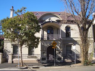
The Cathedral of the Annunciation of Our Lady is a heritage-listed former Anglican church and now Greek Orthodox cathedral located at 242 Cleveland Street, Redfern, New South Wales, Australia. The church was designed by Edmund Blacket and the rectory was designed by John Burcham Clamp and built from 1848. It is also known as the Greek Orthodox Cathedral; St Paul's Anglican Church; St Pauls Church of England; Cathedral of the Annunciation of Our Lady Theotokos. The property is owned by Greek Orthodox Archdiocese of Australia. It was added to the New South Wales State Heritage Register on 17 April 2012.
