
Offa's Dyke Path is a long-distance footpath loosely following the Wales–England border. Officially opened on 10 July 1971, by Lord Hunt, it is one of Britain's National Trails and draws walkers from throughout the world. About 60 miles (97 km) of the 177-mile (285 km) route either follows, or keeps close company with, the remnants of Offa's Dyke, an earthwork traditionally thought to have been constructed in the late 8th century on the orders of King Offa of Mercia.

Moel Hebog is a mountain in Snowdonia, north Wales which dominates the view west from the village of Beddgelert. It gives name to a whole range of peaks in the north-western corner of Snowdonia, which include the Nantlle Ridge and Mynydd Mawr.

The Snowdon Massif is one of the three mountain groups in Snowdonia, north Wales, to include mountains over 3,000 feet (914 m) high. It occupies the area between Beddgelert, Pen-y-Pass and Llanberis. It is surrounded by the Glyderau to the north-east, Moel Siabod to the east, the Moelwynion to the south, Moel Hebog, the Nantlle Ridge and Mynydd Mawr to the west, and by flatter land leading down to Caernarfon and the Menai Strait to the north-west.

The Clwydian Range is a series of hills in the north-east of Wales that runs from Llandegla in the south to Prestatyn in the north, the highest point being the popular Moel Famau. The range forms part of the Clwydian Range and Dee Valley Area of Outstanding Natural Beauty.
Penycloddiau is a hill in Flintshire, Wales, and one of five Marilyns in the Clwydian Range.

Moel Eilio is a mountain in Snowdonia, North Wales, that is situated approximately 3 miles north-west of Snowdon itself. It has two subsidiary tops, Foel Gron and Foel Goch (Eilio). The average annual temperature of the mountain is around 6 degrees Celsius. During the winter season, some significant accumulations of snowfall is known to take place on Moel Eilio, due to its relatively flat, grassy slopes.

Moel Druman is a mountain in Snowdonia, North Wales and forms part of the Moelwynion. It is a subsidiary summit of Allt-fawr.

The Moelwynion are a group of mountains in central Snowdonia. They extend from the north-east of Porthmadog to Moel Siabod, the highest of the group. The name derives from the names of two of the largest mountains in the group, Moelwyn Mawr and Moelwyn Bach, 770m and 710m, respectively. Moel Siabod, to the north, is the highest at 872m.

Moel Penamnen is a mountain just north of Blaenau Ffestiniog, North Wales and forms part of the Moelwynion.

Mynydd Mawr is a mountain in Snowdonia, North Wales, approximately 7 km (4.3 mi) west of Snowdon itself, overlooking Llyn Cwellyn and being the northern outlier of the Moel Hebog group. A popular ascent starts from Rhyd Ddu. On its western flank are the remains of ancient settlements and field systems. The profile of Mynydd Mawr from the north is often thought to resemble an elephant lying down, and consequently the mountain is often colloquially also called "Yr Eliffant", or "Elephant Mountain" by non-Welsh speakers.
Moel Tryfan is a small mountain near the villages of Rhosgadfan, Y Fron and Betws Garmon, in northern Gwynedd. The higher and more famous peak of Tryfan above Dyffryn Ogwen has also sometimes been referred to as "Moel Tryfan" in the past.
The Alyn Gorge is a gorge section of the River Alyn north between Loggerheads and Rhydymwyn in Wales. The west side of the valley rises gently to Moel Famau, while the east bank is along parts a cliff with evidence of tram lines and old quarry workings.

Denbigh Moors is an upland region in Conwy and Denbighshire in north-east Wales, between Snowdonia and the Clwydian Range. It includes the large reservoirs Llyn Brenig and Llyn Alwen, and the Clocaenog Forest, which has one of Wales's last populations of red squirrels. It also contains the open heath Hafod Elwy Moor National Nature Reserve.

Moel Lefn is a summit in Snowdonia. It is a subsidiary peak of Moel Hebog and a sister peak of Moel yr Ogof. Its summit marks the end of the Hebog ridge.

Moel y Parc is a hill on the border between Denbighshire and Flintshire in Wales. It is one of the Clwydian Hills, rising 398 metres (1,306 ft) above sea level and is located at OS grid reference SJ114703. There is a television mast near the summit. The summit marks the boundary of Aberwheeler and Ysceifiog communities, and is the site of a cairn and tumulus.

Y Ro Wen is a mountain just north of Blaenau Ffestiniog, North Wales and forms part of the Moelwynion.

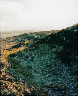
Moel y Gaer is an Iron Age hillfort located on a summit at the southern end of Halkyn Mountain, overlooking the village of Rhosesmor, Flintshire, Wales. It is a well-preserved hillfort overlooking the Dee Estuary. Excavations in the early 1970s revealed a sequence of defensive structures made of timber and several phases of building work inside the ramparts.
Moel Eilio, is a 546-metre (1,791 ft) hill in the eastern Carneddau of northern Wales. It looks very prominent on the approach from the north towards Llanrwst along the Conwy Valley.

Moel y Gamelin is a hill in Denbighshire, North Wales, to the northwest of the town of Llangollen. It is the highest summit of a range which stretches eastwards from near the village of Carrog to the Horseshoe Pass traversed by the A542 road, and reaches an elevation of 577 metres (1,893 ft) above sea level. The western part of the range is known as Llantysilio Mountain whilst the eastern end is referred to as Maesyrchen Mountain. At its top is a round cairn, of unknown date, measuring about 30 metres (100 ft) in diameter and 1.8 metres (6 ft) high. It is in the Clwydian Range and Dee Valley Area of Outstanding Natural Beauty.
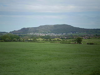
Moel Hiraddug, also known as Y Foel, is a hill fort and hill in the Clwydian Range of north-east Wales. The northern part of the hill has been eaten away by limestone quarrying. An Iron Age hillfort crowns the hill, called Moel Hiraddug. Its ridge runs North-South and it lies above the village of Dyserth. The views from the top are extensive and include Snowdonia. It is 265 metres above sea level.

