Until 1977 Moelingen was a municipality of its own. In that year it became part of the Voeren municipality.
In this village, like in all of the Belgian (as well as the neighbouring Dutch) province of Limburg, predominantly "Limburgs" is spoken, a Low Frankish dialect, closely related to Flemish.[4]
Geography
Berwinne river, some 50 meters from the place where it flows into the Meuse river
Moelingen is the westernmost of the six villages that together form the Voeren municipality [5]
It is located in the valley of the Meuse river and on the river Berwinne (Berwijn),[5] which, a little further westward, flows into the Meuse.
Further westward, across the Meuse river, the southern end of the Caestert Plateau (part of the Mount Saint Peter) is situated, as well as the village of Lieze (in French "Lixhe"), which is part of the WallonianWezet (in French "Visé") municipality.
On its north side, Moelingen abuts the Belgian border with the Netherlands, just south of Withuis[nl],[5] a hamlet in the Dutch municipality of Eijsden-Margraten. Withuis is partly situated on the Belgian side of the border, so that it once partly belonged to the former municipality of Moelingen and by now partly belongs to the municipality of Voeren.
Also on its west and its east side Moelingen more or less abuts the Belgian border with the Netherlands, as it is situated in a peak in this border. As a result, on its northeast side its neighbouring place is Mesch, an ancient village in the municipality of Eijsden-Margraten.
Further on its east side (behind the frontier heading northwards again) its neighbouring place is Gravenvoeren, more or less the main village of the Voeren municipality.
To the south Moelingen is bordering the municipality of Visé.
Sights
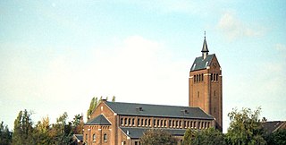
Our-Lady-In-Heaven Church and square
Our-Lady-In-Heaven Church in Moelingen has a 14th-century Gothic nave and a Romanesque tower from the 12th century, but the stucco vaults were the result of reconstruction in 1715.[5]
The old bridge across the Berwinne was built in 1768.[5]
History
Moelingen was formerly part of Dalham County (Graafschap Dalhem), once an independent principality, but after 1239 a county under the Duchy of Brabant.
The village was largely destroyed in 1914 during the German invasion of World War I. When it was rebuilt after the war, the streets were widened and the plaza enlarged.[6]
Until World War II the village was mainly agricultural, but since then it has become increasingly urban.[4]
Marcel Kerff, (Maartensvoeren, 1866 - Moelingen, 1914) cyclist; (later on hung by invading Germans during World War I. There is a monument in Moelingen to him and all Belgian cyclists who died in that war).[8]
1 2 Vanfermeeren, Sonja (1996). "Language attitudes on either side of the linguistic frontier: a sociolinguistic survey in the Voeren/Fouron-area and in Old Belgium North". Contrastive Sociolinguistics. Berlin: Walter de Gruyter. pp.160–162. ISBN978-3-11-014966-1.
1 2 3 4 5 Bousack, Bruno; Voß, Klaus (2011). Radfahren in der Euregio - Flache Strecken (in German). 2. Aachen: Meyer & Meyer Verlag. pp.104. ISBN978-3-89899-619-8.
Limburg is the southernmost of the 12 provinces of the Netherlands. The province is in the southeastern part of the country, stretched out from the north, where it touches the province of Gelderland. Its northern part has the province of North Brabant to its west. Its long eastern boundary is the international border with the German state of North Rhine-Westphalia. Much of the west border runs along the River Maas, bordering the Flemish province which is also named Limburg. On the south end it borders the Walloon province of Liège. The Vaalserberg is on the extreme south-eastern point, marking the tripoint of the Netherlands, Germany and Belgium.
The Meuse or Maas is a major European river, rising in France and flowing through Belgium and the Netherlands before draining into the North Sea from the Rhine–Meuse–Scheldt delta. It has a total length of 925 km.
Limburg is a province in Belgium. It is the easternmost of the five Dutch-speaking provinces that together form the Region of Flanders, one of the three main political and cultural sub-divisions of modern Belgium.
Eijsden is a place situated in the very south of the European country the Netherlands. It is located in the southeastern part of the province of Limburg.
Margraten is a village and a former municipality in the southeastern part of the Netherlands.
Voeren is a Flemish Dutchspeaking municipality with facilities for the Frenchspeaking minority, located in the Belgian province of Limburg. Bordering the Netherlands to the north and the Walloon province of Liège to the south, it is geographically detached from the rest of Flanders, making Voeren an exclave of Flanders. Voeren's name is derived from that of a small right-bank tributary of the Meuse, the Voer, which flows through the municipality.
Visé is a municipality and city of Belgium, where it is located on the river Meuse, in the Walloon province of Liège.
The Duchy of Limburg or Limbourg was an imperial estate of the Holy Roman Empire. Its chief town was Limbourg-sur-Vesdre, is today located within the Belgian province of Liège, with a small part in the neighbouring province of Belgian Limburg, within the east of Voeren.
Eckelrade is a village in the Dutch province of Limburg. It is part of the municipality of Eijsden-Margraten, and situated about 8 km southeast of the town of Maastricht.
Gronsveld is a village in the Dutch province of Limburg. It is part of the municipality of Eijsden-Margraten and situated southeast of the municipality of Maastricht, to which it is bordering.
Mesch is a village in the Dutch province of Limburg.
Oost is a village in the south of the Netherlands. There it is situated near the "Maas" ("Meuse") river in the southwestern part of the province of Limburg.
Sint Geertruid is a village in the Dutch province of Limburg. It is located the municipality of Eijsden-Margraten.
The Voer is a small river in Belgium and the Netherlands. It is a right-bank tributary to the river Meuse. It has three (creek-) tributaries of its own: the Veurs, the Noor and the Beek.
Oost-Maarland is a place in the south east of the European country Netherlands. There it is an administrative population centre in the Eijsden-Margraten municipality, which forms part of the Province of Limburg. In fact Oost-Maarland consists of two separate places with a different history. One is the village and former municipality of Oost, whereas the other is an in a distance of a few hundred metres separately to the southeast situated township called Maarland.
Low Dietsch refers to a handful of transitional Limburgish–Ripuarian dialects spoken in a number of towns and villages.
Maastricht railway station is located in Maastricht in Limburg, Netherlands. It is the main railway station in Limburg's capital city. It is the southern terminus of the Alkmaar–Maastricht intercity service by NS. Additionally, Arriva and the Belgian NMBS serve the station with local trains.
The Berwinne is a small river in the north-eastern part of Belgium. It's a right-bank tributary to the Meuse river and flows over a distance of 31.9 kilometres through the provinces of Liège and Limburg. Its source is located in the eastern part of the municipality of Aubel, near the Henri-Chapelle American Cemetery and Memorial. From there the Berwinne river flows, generally spoken, in northwestern direction, through places like Val-Dieu Abbey, Dalhem and Moelingen, before joining the Meuse between Visé and the Dutch border.
Eijsden-Margraten (pronunciation) is a municipality situated in the very south of the Netherlands. There it is located in the southeastern part of the province of Limburg.
The Noor or Langwater is a river in the Netherlands and Belgium. The Noor is a right-bank tributary to the river Voer, which later joins the Meuse. Rising in Eijsden-Margraten, in the Dutch province of Limburg, the Noor eventually drains in the river Voer in Voeren, in the Belgian province of Limburg.
This page is based on this Wikipedia article Text is available under the CC BY-SA 4.0 license; additional terms may apply. Images, videos and audio are available under their respective licenses.