
The Meuse or Maas is a major European river, rising in France and flowing through Belgium and the Netherlands before draining into the North Sea from the Rhine–Meuse–Scheldt delta. It has a total length of 925 km.

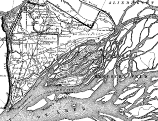
's-Hertogenbosch, French: Bois-le-Duc, ; German: Herzogenbusch, colloquially known as Den Bosch, is a city and municipality in the Netherlands with a population of 157,486. It is the capital of the province of North Brabant and its fourth largest by population. The city is south of the Maas river and near the Waal.

The Zuid-Willemsvaart is a canal in the south of the Netherlands and the east of Belgium.

Hollands Diep is a river in the Netherlands, and an estuary of the Rhine and Meuse rivers. Through the Scheldt-Rhine Canal it connects to the Scheldt river and Antwerp.
The Nieuwe Merwede is a Dutch canal, mainly fed by the river Rhine, that was constructed in 1870 to form a branch in the Rhine–Meuse delta. It was dug along the general trajectories of a number of minor Biesbosch creeks to reduce the risk of flooding by diverting the water away from the Beneden Merwede, and to facilitate navigation and regulate river traffic in the increasingly silted-up delta.

The Dommel is a small river in Belgium and the Netherlands, left tributary of the Dieze. It is 120 km long, of which 85 km in the Netherlands. The Dommel takes in water from the Keersop, Tongelreep, Run, Gender and Kleine Dommel streams and merges at 's-Hertogenbosch with the Aa stream to form the river Dieze, which subsequently flows towards the Meuse. The main cities and towns along the Dommel's course are Peer, Neerpelt, Valkenswaard, Dommelen, Eindhoven, Son en Breugel, Sint-Oedenrode, Boxtel, Sint-Michielsgestel and 's-Hertogenbosch.
The Tideway is a part of the River Thames in England which is subject to tides. This stretch of water is downstream from Teddington Lock. The Tideway comprises the upper Thames Estuary including the Pool of London.
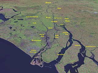
The Merwede is the name of several connected stretches of river in the Netherlands, between the cities of Woudrichem, Dordrecht and Papendrecht. The river is part of the Rhine–Meuse–Scheldt delta and is mostly fed by the river Rhine.

The Aa is a small river in the Netherlands. It rises near Nederweert in the southeastern province of Limburg, in the Peel region. It flows northwest through the province of North Brabant towards 's-Hertogenbosch, roughly along the Zuid-Willemsvaart canal. In 's-Hertogenbosch, at the confluence of the Aa and the Dommel, the river Dieze is formed, which flows into the Meuse a few km further. The main cities and towns along the Aa's course are Asten, Helmond, Veghel and 's-Hertogenbosch.

Engelen is a village in the Dutch province of North Brabant. It is part of the municipality of 's-Hertogenbosch.

Nuland is a village in the Dutch province of North Brabant. It is located about 8 km (5 mi) east of 's-Hertogenbosch.

Van Vlissingen en Dudok van Heel was a famous nineteenth-century Dutch machine factory. It built steam engines and machinery for the sugar industry and for maritime purposes, as well ships, rolling stock and large metal structures like the Moerdijk bridge and a floating dock. In 1871 it was reorganized to become the public company Koninklijke Fabriek van Stoom- en andere Werktuigen. In a second reorganization in 1890, parts of it were saved and continued under the name Koninklijke Nederlandsche Fabriek van Werktuigen en Spoorwegmaterieel, renamed to Werkspoor in 1927.

Bridgeview is a neighbourhood in the Whalley town centre of Surrey, British Columbia, Canada, that stretches south from the Fraser River to King George Boulevard. The neighbourhood consists of all the low-lying area between the Port Mann Bridge in the east and the Pattullo Bridge in the west.

Fort Crèvecoeur was a Dutch fortress near 's-Hertogenbosch. It is now used as a military exercise terrain.

The Drongelens Canal is a drainage canal that runs from 's-Hertogenbosch to Drongelen in North Brabant. The colloquial Dutch name, and the name used on street signs is Drongelens Kanaal. The official Dutch name is Afwateringskanaal van 's-Hertogenbosch naar Drongelen.

The Lage Zwaluwe-'s-Hertogenbosch railway or Langstraatspoorlijn is a defunct and partially open railway line in North Brabant, the Netherlands. It ran through the Langstraat from Lage Zwaluwe railway station via Waalwijk to 's-Hertogenbosch railway station. Part of the line had been repurposed for recreation. It has the nickname Halvezolenlijntje. The Moerputten Bridge is a unique piece of engineering.

Engelen Lock is a lock with vertical-lift bridge in the Dieze Canal near Engelen, North Brabant, just before the canal exits into the Meuse.
Hooge Zwaluwe is a village in the Dutch province of North Brabant. It is located in the municipality of Drimmelen, about 3.5 km north-west of Made.

Hedel Bridge is a tied-arch bridge over the Meuse dating from 1937 near Hedel, Gelderland. The bridge was built for the Oude Rijksweg, a former part of the A2 motorway that connected 's-Hertogenbosch to Utrecht.


