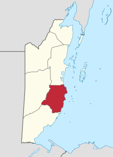
Stann Creek District is a district in the south east region of Belize. According to the 2010 census, the district had a population of 32,166 people. Its capital is the city of Dangriga, formerly known as "Stann Creek Town." Stann comes from "stanns," or safe havens used by colonialists coming from the "old world" to the "new world."

St. George's Caye is an island in the Caribbean Sea, eight miles east of Belize City. It is part of the Belize District of Belize, Central America. The village on the island is also known as St. George's Caye. As of 2000, St. George's Caye had a permanent population of about 20 people.

The Gulf or Bay of Honduras is a large inlet of the Caribbean Sea, indenting the coasts of Belize, Guatemala, and Honduras. From north to south, it runs for approximately 200 km from Dangriga, Belize, to La Ceiba, Honduras.

Caye Caulker is a small limestone coral island off the coast of Belize in the Caribbean Sea measuring about 5 miles (8.0 km) by less than 1 mile (1.6 km). The town on the island is known by the name Caye Caulker Village. The population of Caye Caulker is approximately 2000 people today and still growing.

Chetumal Bay is a large bay of the western Caribbean Sea on the southern coast of the Yucatán Peninsula.
Goff's Caye is a small island off the shore of Belize City, Belize. It sits right on the edge of the Belize Barrier Reef with waters to the south and east being only 0.6 to 3 metres deep. Goff's Caye is registered as an archaeological site due to its Colonial era settlement. During the Colonial times, the island served as a fishing camp, trade center and cemetery. Among those interred in the cemetery are a number of crew members from HMS Blossom, who died of Yellow Fever during a visit to the colony in August 1830.

Caye Caulker Airport is an airport that serves Caye Caulker, an island 20 kilometres (12 mi) off the coast of Belize.

The Belize Barrier Reef is a series of coral reefs straddling the coast of Belize, roughly 300 meters (980 ft) offshore in the north and 40 kilometers (25 mi) in the south within the country limits. The Belize Barrier Reef is a 300-kilometer (190 mi) long section of the 900-kilometer (560 mi) Mesoamerican Barrier Reef System, which is continuous from Cancún on the north-eastern tip of the Yucatán Peninsula through the Riviera Maya and down to Honduras, making it the second largest coral reef system in the world after the Great Barrier Reef in Australia. It is Belize's top tourist destination, popular for scuba diving and snorkeling and attracting almost half of its 260,000 visitors. It is also vital to the country's fishing industry.

Caye Chapel is a small, private island in Belize, 16 miles (26 km) north-northeast of Belize City and 3 miles (4.8 km) south of Caye Caulker. It was once owned by Isaiah Emmanuel Morter, Belize's first African millionaire.

Tobacco Caye is a tiny island in Belize, about 10 miles east of Dangriga. It is approximately three acres in area, shaped like an egg, with a north-south dimension of about 240 m (260 yd) and an east-west dimension of 125 metres. It has a permanent population of about 20, and sees a regular stream of travelers thanks to the four small lodges on the island.
Laughing Bird Caye is an island off the coast of Placencia, Belize. On 21 December 1991, Laughing Bird Caye National Park was declared. It is spread over an area of 1.8 acres (0.73 ha). The national park is named after the laughing gull which breeds there.

Blackadore Caye is a small island in Belize, west of Ambergris Caye, in the Caribbean Sea, not far from the Belize Barrier Reef.
Bird Island is an island located in the country of Belize.

Half Moon Caye is an island and natural monument of Belize located at the southeast corner of Lighthouse Reef Atoll. This natural monument was the first nature reserve to have been established in Belize under the National Park Systems Act in 1981 and first marine protected area in Central America. This is also Belize's oldest site of wildlife protection since it was first designated as a bird sanctuary in 1924 to protect the habitat of the red-footed booby birds.
Royal Belize is a private island off the coast of Belize. It is a 7.5 acre island resort managed by Muy'Ono that was originally developed as a private retreat.

Turneffe Atoll is located southeast of Ambergris Caye and Caye Caulker, off the coast of Belize in Central America, 20 miles from Belize City, is one of three atolls of the Belize Barrier Reef, besides Glover's Reef and Lighthouse Reef. It is approximately 30 miles long and 10 miles wide, making it the largest coral atoll in Belize and in the Mesoamerican Barrier Reef System. The atoll was officially declared a marine reserve on November 22, 2012.
Harvest Caye is a private island owned by Norwegian Cruise Line, located in southern Belize. The caye features wildlife exhibitions including a blue morpho butterfly house.
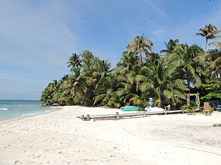
Ranguana Caye is a two-acre private island located roughly 20 miles west of Placencia. According to Peter Eltringham, author of The Rough Guide to Belize, Ranguana Caye has sand softer in comparison to Placencia with taller palm trees. Those exploring the caye, are required to set up transportation through private boat charters. The island includes a dock and moorings for visiting boats, located just off the Belize Barrier Reef. A day tour to the island is through Belize Ocean Club, a resort located in Maya Beach Village near Placencia and managed by Muy'Ono Properties. Ranguana Caye also features three rustic cabanas for overnight guests, with Bully's Beach Bar, a BBQ grill and composting restroom systems for guests. The resort has no pay phones, but features wifi and radio communication. Snorkeling the Belize Barrier Reef and reef fishing are also some activities on the island.
Thatch Caye is an island in Belize, located 9 miles (14 km) off of the coast of Dangriga, about two miles from the Belize Barrier Reef. The 11 acres (4.5 ha) island is near Southwater Caye, Tobacco Caye, Cocoplum Caye, and Fantasy Caye and South Water Caye Marine Reserve.


