Placencia

Last updated
Placencia
Maya Beach, Placencia, Belize.jpg
Placencia Beach
Belize location map.svg
Red pog.svg
Placencia
Coordinates: 16°30′50″N88°22′0″W / 16.51389°N 88.36667°W / 16.51389; -88.36667
Country Flag of Belize.svg  Belize
District Stann Creek
Constituency Stann Creek West
Elevation
11 m (36 ft)
Population
 (2010)
  Total750 (est)
Time zone UTC-6 (Central No DST)
Climate Am

Placencia is a small village located in the Stann Creek District of Belize.

Contents

History

Prior to the European colonization of the Americas, the Placencia Peninsula was inhabited by the Maya. Archaeological evidence suggests that the Maya in this area produced salt and traded it with other settlements along the coast. [1]

In the 17th century, Placencia was settled by English Puritans, originally from Nova Scotia and Providence Island. This settlement died out during the Spanish American wars of independence in the 1820s. [2]

The Placencia Peninsula was resettled in the late 1800s by several families. Placencia prospered and soon became a village, earning its livelihood from the sea.

The Spaniards that traveled the southern coast of Belize gave Placencia its name. At that time Placencia was called Placentia, with the point being called Punta Placentia, or Pleasant Point. [3]

In the late 20th century it became a significant tourism destination, and is now referred to as Placencia Village, or simply Placencia.

On October 8, 2001, Hurricane Iris hit southern Belize with 145 mph winds causing major damage to nearly 95% of buildings in Placencia. Many developers took advantage of plummeted real estate value and an increased development of the peninsula and Placencia proper is consistently on the rise, as well as property value. [4]

Location and geographic setting

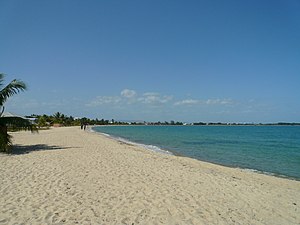
The eastern side of the Peninsula is a long expanse of white sand beach and heavy mangrove in some areas; the western side is bounded by a long narrow north–south trending bay of the Caribbean Sea. Significant settlements on the 18 mile peninsula from North to South include Riversdale Village, Maya Beach Village, the Garifuna village of Seine Bight and finally, Placencia Village. [5] Placencia, the southernmost village on the peninsula, is served by Placencia Airport. [6]

Demographics

The village is home to 1,512 permanent residents according to the 2010 census, while the Placencia Peninsula is home to 3,458 permanent residents, which includes citizens and ex-pats alike. [7] At the time of the 2010 census, 41.9% of the population of Placencia were Creole, 24.5% Mestizo, 10.0% Mixed, 9.2% Caucasian, 3.2% Mopan Maya, 2.9% Garifuna, 2.7% Ketchi Maya, 2.5% East Indian, 1.0% Asian, 0.4% Yucatec Maya, 0.3% African and 1.3% others. [8]

Attractions

Placencia is known for the longest main street which is a sidewalk with many local gift shops, beach bars, hotels and cabanas. Visit Placencia Village guide [12] for businesses in the village.

Related Research Articles

<span class="mw-page-title-main">Dangriga</span> Town in Stann Creek, Belize

Dangriga, formerly known as Stann Creek Town, is a town in southern Belize, located on the Caribbean coast at the mouth of the North Stann Creek River. It is the capital of Belize's Stann Creek District. Dangriga is served by the Dangriga Airport. Commonly known as the "culture capital of Belize" due to its influence on punta music and other forms of Garifuna culture, Dangriga is the largest settlement in southern Belize.

<span class="mw-page-title-main">Stann Creek District</span> District of Belize

Stann Creek District is a district in the south east region of Belize. According to the 2010 census, the district had a population of 32,166 people. Its capital is the town of Dangriga, formerly known as "Stann Creek Town." Stann comes from "stanns," or safe havens used by colonialists coming from the "old world" to the "new world."

<span class="mw-page-title-main">Toledo District</span> District of Belize

Toledo District is the southernmost and least populated district in Belize. Punta Gorda is the District capital. According to the Human Development Index (HDI), it is the second most developed region in the country. The district has a diverse topography which features rainforests, extensive cave networks, coastal lowland plains, and offshore cays. Toledo is home to a wide range of cultures such as Mopan, Kekchi Maya, Creole, Garifuna, East Indians, Mennonites, Mestizos, and descendants of US Confederate settlers.

<span class="mw-page-title-main">San Pedro Town</span> Town in Belize, Belize

San Pedro is a town on the southern part of the island of Ambergris Caye in the Belize District of the nation of Belize, in Central America. According to the 2015 mid-year estimates, the town has a population of about 16,444. It is the second-largest town in the Belize District and largest in the Belize Rural South constituency. The once sleepy fishing village was granted the status of a town in 1984.

<span class="mw-page-title-main">Ambergris Caye</span> Island in Belize

Ambergris Caye, is the largest island of Belize, located northeast of the country's mainland, in the Caribbean Sea. It is about 40 kilometres (25 mi) long from north to south, and about 1.6 kilometres (1 mi) wide. Many parts of the island have been modified by human development since the arrival of coconut plantations in the 17th century, but it remains largely white coral sand with mangrove forest at its center. Its eastern coast runs parallel to the northernmost stretch of the Belize Barrier Reef, a UNESCO World Heritage Site.

<span class="mw-page-title-main">Caye Caulker</span> Place in Belize District, Belize

Caye Caulker is a small limestone coral island off the coast of Belize in the Caribbean Sea measuring about 5 miles (8.0 km) by less than 1 mile (1.6 km). The town on the island is known by the name Caye Caulker Village. The population of Caye Caulker is approximately 2,000 people today and still growing.

<span class="mw-page-title-main">Costa Maya</span> Tourist region in Quintana Roo, Mexico

Costa Maya is a small tourist region in the municipality of Othón P. Blanco in the state of Quintana Roo, Mexico, the only state bounded by the Caribbean Sea to its east. This municipality is close to Chetumal on the border with Belize. The area was generally undeveloped but has been growing rapidly since construction of a large pier to accommodate cruise ships. Costa Maya is also the name of a subdivision near the village of Mahahual. The beach extends from Xcalak in the south to the southern border of Sian Ka'an in the north, a distance of approximately 100 kilometers (62 mi).

Belizean Creoles, also known as Kriols, are a Creole ethnic group native to Belize.

<span class="mw-page-title-main">Belize Barrier Reef</span> Series of coral reefs straddling the coast of Belize

The Belize Barrier Reef is a series of coral reefs straddling the coast of Belize, roughly 300 metres (980 ft) offshore in the north and 40 kilometres (25 mi) in the south within the country limits. The Belize Barrier Reef is a 300-kilometre (190 mi) long section of the 900-kilometre (560 mi) Mesoamerican Barrier Reef System, which is continuous from Cancún on the north-eastern tip of the Yucatán Peninsula through the Riviera Maya and down to Honduras, making it the second largest coral reef system in the world after the Great Barrier Reef in Australia. It is Belize's top tourist destination, popular for scuba diving and snorkeling and attracting almost half of its 260,000 visitors. It is also vital to the country's fishing industry.

Sarteneja is the largest fishing community and the second largest village in Belize. It recorded a population of 3,500 according to a 2016 estimate. The name Sarteneja is a Castilian distortion of its original Mayan name Tza-ten-a-ha, which means 'give me water'.

<span class="mw-page-title-main">Tourism in Belize</span>

Tourism in Belize has grown considerably recently, and it is now the second largest industry in the nation. Belizean Prime Minister Dean Barrow has stated his intention to use tourism to combat poverty throughout the country. The growth in tourism has positively affected the agricultural, commercial, and finance industries, as well as the construction industry. The results for Belize's tourism-driven economy have been significant, with the nation welcoming almost one million tourists in a calendar year for the first time in its history in 2012.

Belize, on the east coast of Central America, southeast of Mexico, was inhabited by the indigenous peoples who fought off the Spaniards in an attempt to preserve their heritage and to avoid the fate of their neighbors who were conquered and under Spanish rule. While this was going on, British pirates would rob Spanish merchant ships and navigate through the shallow waters and small islands even going up river later to hide their bounty. The indigenous people of Belize did not resist the British like they did the Spanish. In the 17th century, however, the British settlement became a formal British crown colony from 1862 through 1964, where they first achieved self government and later in 1981 became an independent country recognized globally with all its territory intact. The British brought along with them slaves taken from Congo and Angola during the eighteenth century.

<span class="mw-page-title-main">History of Belize</span>

The history of Belize dates back thousands of years. The Maya civilization spread into the area of Belize between 1500 BC to 1200 BC and flourished until about 1000 AD. Several Maya ruin sites, including Cahal Pech, Caracol, Lamanai, Lubaantun, Altun Ha, and Xunantunich reflect the advanced civilization and much denser population of that period. The first recorded European incursions in the region were made by Spanish conquistadors and missionaries in the 16th century. One attraction of the area was the availability of logwood, which also brought British settlers.

<span class="mw-page-title-main">Gladden Spit and Silk Cayes Marine Reserve</span>

Gladden Spit and Silk Cayes Marine Reserve (GSSCMR) is a protected marine reserve in the central part of Belize's Barrier Reef. It covers approximately 25,980 acres (10,510 ha) lying 36 kilometres (22 mi) off the coast of Placencia. Established in 2003, The reserve comes under the authority of the government's Fisheries Department, but is managed by the Southern Environmental Association, a community-based organisation.

The Crawl Cay boa is a dwarf Boa imperator population that reaches a maximum length of about 5 feet. Characteristics of this snake are the very gray background colour with black speckling which is also on the head. The snakes have saddling like the common boa, which continue onto the tail.

<span class="mw-page-title-main">Santa Cruz, Stann Creek</span> Village in Stann Creek, Belize

Santa Cruz is a village in Stann Creek District, Belize. It is located 24 miles northwest of the Placencia peninsula.

Maya Beach Village is a village in the Stann Creek District of Belize located on the Placencia Peninsula, between Riversdale Village and Seine Bight. Based on the 2010 national census, Maya Beach has a population of 225 year round residents. The village is home to a number of resorts, boutique hotels, and vacation homes. Notable resorts include Maya Beach Hotel Bistro, Umaya Resort, and Naia Resort & Spa. The village is often considered a part of the peninsula's largest community and namesake, Placencia, which is a short drive from the village. Maya Beach is served by the Placencia Airport, with the closest international hub being Philip S. W. Goldson International Airport in Belize City.

Seine Bight is a village on the Placencia Peninsula located in the Stann Creek District of Belize. It is located 2 and a half miles south of Maya Beach Village and North of the village of Placencia. This small village has roughly 1,000 inhabitants, mostly Garifuna people who subsist on fishing, hunting, and homegrown vegetables. The early settlers named their village for their favored fishing tackle, Seine fishing and a bight, a bend or curve in a coastline.

<span class="mw-page-title-main">Ranguana Caye</span>

Ranguana Caye is a private island with a total area of two acres, approximately 20 miles west of Placencia, Belize. The island harbours a dock and moorings for visiting boats which is located just off the Belize Barrier Reef. Tours are available through the Belize Ocean Club, a resort located in Maya Beach Village near Placencia and managed by Muy'Ono Properties. Snorkeling and reef fishing are also some activities available on the island.

References

  1. Vernon, Lawrence; Young-Westby, Sr, Henry (2014). Placencia and Its Environs. Belize City: Henry Young Enterprises. pp. 8–9.
  2. Vernon, Lawrence; Young-Westby, Sr, Henry (2014). Placencia and Its Environs. Belize City: Henry Young Enterprises. p. 9.
  3. "Placencia History". Placencia Tourism Center. 2008. Archived from the original on 2009-03-06. Retrieved 2009-04-22.
  4. consejo.bz/weather/storms.html
  5. "Location - Welcome to Placencia". 15 January 2020.
  6. "Getting Around - Welcome to Placencia". 20 January 2020.
  7. "Population – Placencia BTIA". Archived from the original on 2017-04-07. Retrieved 2017-04-06.
  8. Population & Housing Census 2010
  9. "Spawning aggregations of Lutjanus cyanopterus (Cuvier) on the Belize Barrier Reef over a 6 year period" (PDF). Journal of Fish Biology: 83–101. Archived from the original (PDF) on 20 Apr 2022.
  10. "Diving with Whale Sharks: The Best Places". 12 November 2019.
  11. "Belize Discover - Placencia". New World Hotels Inc. Archived from the original on 2009-04-11. Retrieved 2009-04-22.
  12. "Home". www.placenciavillageguide.com. Retrieved 2021-01-29.
  13. "A Day at Tiny Ranguana Caye off Placencia, Belize...This is All I Need!". 21 July 2014.

16°30′50″N88°22′00″W / 16.51389°N 88.36667°W / 16.51389; -88.36667