Related Research Articles

Stann Creek District is a district in the south east region of Belize. According to the 2010 census, the district had a population of 32,166 people. Its capital is the town of Dangriga, formerly known as "Stann Creek Town." Stann comes from "stanns," or safe havens used by colonialists coming from the "old world" to the "new world."

Hattieville is a village in the Belize District of the nation of Belize. It is located at 17N 88W, at an elevation of 196 feet above mean sea level, and has a population of about 1,300 people. Hattieville was established as a refugee camp after Hurricane Hattie made many people homeless in Belize City when it hit in 1961, but it became a permanent town.
Trial Farm is a village near Orange Walk Town in the Orange Walk District of the nation of Belize. According to the 2000 census, it had a population of 3,443 people. It is located at 29 metres above sea level.
Progreso is a village in the Corozal District of the nation of Belize.
Xaibe is small rural settlement in the country of Belize mainly consisting of people from the Yucatec Maya ethnicity. It is located in Corozal District. The name Xaibe literally means 'crossroads'. The people of the Maya civilization often traversed across the village to reach other Maya villages. The population of the village is very small. The last available data of the population of Xaibe in 2010 revealed that it had a modest population of approximately 1,575 people. There is, however, evidence of the fact that the people belonging to the Maya civilization resided in the Xaibe village. These people then gradually shifted to Mexico, just across the border at the time of the Caste War of Yucatán. The village is known for celebrating the Maya tradition Hanal Pixan which means "food for the souls" also known as Day of the Dead.

Placencia is a small village located in the Stann Creek District of Belize.

Consejo is a village in the north of Corozal District, Belize. Consejo is located on a point of land where the bays of Corozal and Chetumal meet. Consejo is about 8 miles from the district capital of Corozal Town, and 2 miles (3.2 km) across the water from Chetumal, Mexico.
Roaring Creek is a small village in the Cayo District of Belize, just north-west of Belmopan. Its name is derived from the creek waterfalls which flow into the Belize River next to the Guanacaste Park area.
Maya Island Air is an airline with its head office on the second floor of Building #1 of Belize City Municipal Airport in Belize City, Belize. It operates regular scheduled flights to 11 destinations within Belize and chartered flights to Mexico, Guatemala, and Honduras. Its main base is the Philip S. W. Goldson International Airport.

Hopkins Village is a coastal village in eastern Belize.

San Joaquín is a village in the Corozal District of Belize. It is one of the largest villages in Corozal. The town was formed as a result of Mestizos migrating to escape the 1847–1901 Caste War of Yucatán.

Monkey River is a coastal watercourse in southern Belize that rises in the Maya Mountains and discharges to the Caribbean Sea near Monkey River Town. One of Belize's major rivers, Monkey River has northern headwaters which originate in the Cockscomb Basin Wildlife Sanctuary, where the Swasey Branch drains the East Basin of that wildlife sanctuary. Further south, the Bladen Branch watercourse drains the eastern slopes of the Maya Mountains including the ancient Mayan settlement areas of Lubaantun and Nim Li Punit. These two watercourses join to form the Monkey River approximately 16 kilometres upstream from the mouth of the Monkey River. The Monkey River is readily navigated throughout the year using small boats, but navigation above the major confluence becomes more difficult due to lack of depth when the dry season starts about February. Habitats in this watershed provide cover for such diverse species as the ocelot, jaguar, Guatemalan black howler, bare-throated tiger heron, Morelet's crocodile, fer-de-lance and manatee.

Calcutta is a village in the Corozal District of Belize.
Gardenia is a village in Belize District, Belize located about 20 miles (32 km) north of Belize City.
Burrell Boom is on the Belize River twenty miles above Belize City, Belize. Tourists pass through this historic village on their way to the Community Baboon Sanctuary, where the population of black howler monkeys has grown to over 2,000.
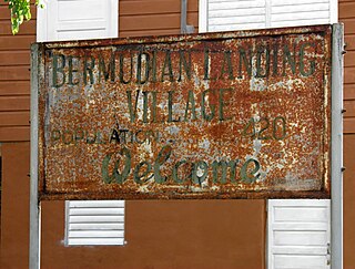
Bermudian Landing is a village in the nation of Belize, located near Scotland Halfmoon in Belize District. The name comes from the Bermuda grass planted by the early loggers to feed their oxen, who were used to drag the mahogany to the landing.
Chan Chen is a village located in Corozal District, Belize. Most of the inhabitants speak Spanish or Yucatec Maya, along with some English. The name Chan Chen is Yucatec maya meaning "small well" in English. Most Chan Chen inhabitants are of Maya ancestry.
Seine Bight is a village on the Placencia Peninsula located in the Stann Creek District of Belize. It is located 2 and a half miles south of Maya Beach Village and North of the village of Placencia. This small village has roughly 1,000 inhabitants, mostly Garifuna people who subsist on fishing, hunting, and homegrown vegetables. The early settlers named their village for their favored fishing tackle, Seine fishing and a bight, a bend or curve in a coastline.
Ranguana Caye is a private island with a total area of two acres, approximately 20 miles west of Placencia, Belize. The island harbours a dock and moorings for visiting boats which is located just off the Belize Barrier Reef. Tours are available through the Belize Ocean Club, a resort located in Maya Beach Village near Placencia and managed by Muy'Ono Properties. Snorkeling and reef fishing are also some activities available on the island.

Cotton Tree is a village in the Cayo District of central interior Belize. The village is situated 5km to the northeast of Belmopan along the Western Highway. The surrounding area is agricultural with the most frequent crops being citrus and banana. It is one of 192 municipalities administered at the village level in the country for census taking purposes.
References
- ↑ "Population – Placencia BTIA".
- ↑ "Getting to Placencia – Placencia BTIA".
- ↑ Population & Housing Census
16°36′55″N88°21′15″W / 16.6152°N 88.3542°W
| | This Belize-related article is a stub. You can help Wikipedia by expanding it. |