Transport in Belize mostly consists of bus transportation on Belize's roads. There are some navigable waterways.
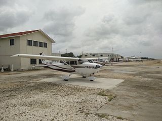
Tropic Air is an airline operating scheduled services from Belize. Founded in 1979 by John Greif III with just a single airplane and two employees, Tropic has steadily grown to a fleet of 17 light aircraft and now operates over 200 daily scheduled flights. The airline flies to 13 destinations in Belize, Mexico, El Salvador and Honduras. The airline also offers private charters as well as various sightseeing tours.

Port Stanley Airport, also merely known as Stanley Airport, is a small civil airport in the Falkland Islands, located two miles from the capital, Stanley. This airport is the only civilian airport in the islands with a paved runway. However, the military airbase at RAF Mount Pleasant, located to the west of Stanley, functions as the islands' main international airport, because it has a long runway capable of handling wide-body aircraft, and allows civilian flights by prior permission from the UK Ministry of Defence (MoD). Port Stanley Airport is owned by the Government of the Falkland Islands, operated by the Falkland Islands Government Air Service, and is used for internal flights between the islands and flights between the Falklands and Antarctica. It has two asphalt-paved runways; its main runway 09/27 is 918 by 19 metres, and its secondary runway 18/36 is 338 metres long.
Rostraver Airport is a public use airport in Westmoreland County, Pennsylvania, United States.
Beaver Island Airport is a public use airport located on Beaver Island in Charlevoix County, Michigan, United States. It is owned by St. James Township and Peaine Township. It is included in the Federal Aviation Administration (FAA) National Plan of Integrated Airport Systems for 2017–2021, in which it is categorized as a local general aviation facility.

Mackinac Island Airport is a public use airport in Mackinac County, Michigan, United States. It is located one nautical mile (1.9 km) northwest of downtown Mackinac Island, Michigan in the center of Mackinac Island. The airport is owned by Mackinac Island State Park Commission. It is included in the Federal Aviation Administration (FAA) National Plan of Integrated Airport Systems for 2017–2021, in which it is categorized as a basic general aviation facility.

Caye Caulker Airport is an airport that serves the island of Caye Caulker, 20 kilometres (12 mi) off the coast of Belize. After Maya Island Air and Tropic Air suspended service to Caye Caulker in 2017 due to the dangerous condition of the runway, the airport underwent a BZ$3.6 million renovation that included asphalt pavement and runway lighting.
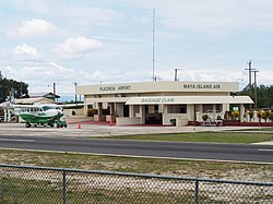
Sir Barry Bowen Municipal Airport is an airport serving Belize City, Belize. It is only one mile from the city center, and is more centrally located to the city than is Belize City International Airport. It mostly provides travel to Belize's cayes, allowing faster passage to the cayes than by boat or water taxi. The airport is named after the late Belizean politician and entrepreneur Barry Bowen.
Cheikh Larbi Tébessa Airport is a public airport located 1.35 nautical miles north of Tébessa, the capital of the Tébessa province (wilaya) in Algeria.

Mustique Airport is a private airfield owned by the Mustique Company for public use and is located on Mustique island, part of Saint Vincent and the Grenadines in the Caribbean Sea. It is used by civil aviation and national airlines using turboprop planes.

Patrick Jason Faber is a Belizean politician. He was the leader of the Opposition. He formerly served as the minister of Education, Youth Sports and Culture. In July 2020 he was appointed the leader of the United Democratic Party, after Prime Minister Dean Barrow stated his plans to retire at the end of his term.

Hector Silva airstrip is an airport located in Cayo District serving Belmopan, the capital city of Belize. The runway is on the northern edge of the city off the George Price Highway, and has a small terminal building.
Chan Chich Airstrip is an airport serving the Chan Chich Lodge and the Gallon Jug Estate in the Orange Walk District of Belize. The airport is 6 kilometres (4 mi) east of the border with Guatemala.

Union Island Airport is the airport serving Union Island, Grenadines Parish, Saint Vincent and the Grenadines. It is located about 0.25 miles (0.40 km) from the town of Clifton, one of the country's main tourist centers and a major destination for charter leisure flights during the winter holiday season and Easter, for "Easterval" celebration. The airport serves as a focus city for flag carrier SVG Air and features flights to several short-haul regional destinations. It is the southmost airport of St. Vincent and the Grenadines.
Independence Airport, also known as Savannah Airport or Mango Creek Airport, is an airport serving Independence and Mango Creek, a coastal community straddling the border between Toledo and Stann Creek Districts in Belize. The airport runs along the Independence Highway, 4 kilometres (2 mi) inland from the coast.
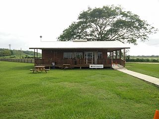
Manatee Airport is a public use airport serving the rural community of Spanish Lookout, Cayo District, Belize.
Orange Walk Airport is a public use airport 3 kilometres (2 mi) southwest of Orange Walk Town, Orange Walk District, Belize. The airport was also known as Tower Hill Airport.
Silver Creek Airport is an airport serving the Stann Creek District, Belize. The rural airport is 7 kilometres (4 mi) inland from the Caribbean coast, and 6 kilometres (4 mi) northeast of Santa Cruz.

Matthew Spain Airport, formerly called Central Farm Airstrip, is a public use airport serving San Ignacio, a town in the Cayo District of Belize. The airport is 5 kilometres (3 mi) northeast of Santa Elena.
San Ignacio Town Airstrip is a public use airport serving San Ignacio, a town in the Cayo District of Belize. The airport is 6 kilometres (4 mi) southwest of San Ignacio and 5 kilometres (3.1 mi) east of the border with Guatemala.