Beaver Island Airport is a public use airport located on Beaver Island in Charlevoix County, Michigan, United States. It is owned by St. James Township and Peaine Township. It is included in the Federal Aviation Administration (FAA) National Plan of Integrated Airport Systems for 2017–2021, in which it is categorized as a local general aviation facility.

Caye Caulker Airport is an airport that serves the island of Caye Caulker, 20 kilometres (12 mi) off the coast of Belize. After Maya Island Air and Tropic Air suspended service to Caye Caulker in 2017 due to the dangerous condition of the runway, the airport underwent a BZ$3.6 million renovation that included asphalt pavement and runway lighting.
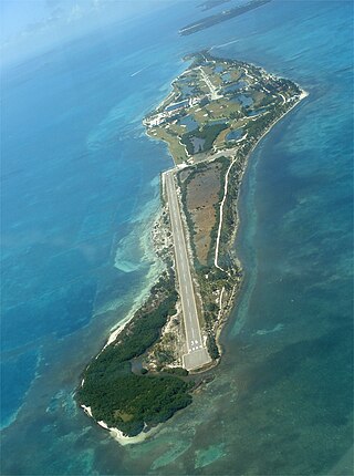
Caye Chapel Airport is an airport serving Caye Chapel, an island 20 kilometres (12 mi) off the coast of Belize. The runway is at the southern tip of the narrow cay.
Corozal Airport is an airport that serves Corozal, Belize. It is located at the south entrance of Corozal, in Ranchito village, and is therefore known as Ranchito Airport.

Dangriga Airport, also called Pelican Beach Airstrip, is a public use airport located 1 kilometre (1 mi) north of Dangriga, a coastal town in the Stann Creek District of Belize.

Placencia Airport is an airport that serves Placencia, Belize. It has a paved strip and crosses the peninsula from East to West.
Punta Gorda Airport is an airport serving Punta Gorda, a town on Amatique Bay in the Toledo District of southern Belize. The airport is within the town, and less than a kilometer from the bay.
Big Creek Airport is an airport serving Big Creek, a sea port in the Toledo District of Belize.
Sarteneja is the largest fishing community and the second largest village in Belize. It recorded a population of 3,500 according to a 2016 estimate. The name Sarteneja is a Castilian distortion of its original Mayan name Tza-ten-a-ha, which means 'water between the rocks'.

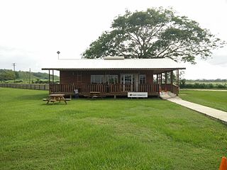
Hector Silva airstrip is an airport located in Cayo District serving Belmopan, the capital city of Belize. The runway is on the northern edge of the city off the George Price Highway, and has a small terminal building.
Independence Airport, also known as Savannah Airport or Mango Creek Airport, is an airport serving Independence and Mango Creek, a coastal community straddling the border between Toledo and Stann Creek Districts in Belize. The airport runs along the Independence Highway, 4 kilometres (2 mi) inland from the coast.
Melinda Airport is an airstrip just east of Hope Creek, a village in the Stann Creek District of Belize. The gravel runway is on the south edge of the Melinda Forest Reserve, and just off the Hummingbird Highway.
Manatee Airport is a public use airport serving the rural community of Spanish Lookout, Cayo District, Belize.
Orange Walk Airport is a public use airport 3 kilometres (2 mi) southwest of Orange Walk Town, Orange Walk District, Belize. The airport was also known as Tower Hill Airport.
Silver Creek Airport is an airport serving the Stann Creek District, Belize. The rural airport is 7 kilometres (4 mi) inland from the Caribbean coast, and 6 kilometres (4 mi) northeast of Santa Cruz.

Matthew Spain Airport, formerly called Central Farm Airstrip, is a public use airport serving San Ignacio, a town in the Cayo District of Belize. The airport is 5 kilometres (3 mi) northeast of Santa Elena.
San Ignacio Town Airstrip is a public use airport serving San Ignacio, a town in the Cayo District of Belize. The airport is 6 kilometres (4 mi) southwest of San Ignacio and 5 kilometres (3.1 mi) east of the border with Guatemala.
Johnny Chan Chen Airstrip is an airport serving Chan Chen, a village in the Corozal District of Belize. The airport is 1.6 kilometres (1 mi) west of Chan Chen and 7 kilometres (4.3 mi) northwest of Corozal.