Corozal Airport

Last updated
Corozal Airport

Ranchito Airport
Summary
Airport typePublic
Serves Corozal, Belize
LocationRanchito
Elevation  AMSL 4.0 ft / 1 m
Coordinates 18°22′55″N88°24′40″W / 18.38194°N 88.41111°W / 18.38194; -88.41111 Coordinates: 18°22′55″N88°24′40″W / 18.38194°N 88.41111°W / 18.38194; -88.41111
Map
Belize location map.svg
Airplane silhouette.svg
CZH
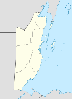
Location in Belize
Runways
Direction LengthSurface
mft
07/256702,198Asphalt
Sources: GCM [1] SkyVector [2]

Corozal Airport( IATA : CZH, ICAO : MZCZ) is an airport that serves Corozal, Belize. It is located at the south entrance of Corozal, in Ranchito village, and is therefore known as Ranchito Airport.
Contents

Airlines and Destinations

Passenger

AirlinesDestinations
Maya Island Air Belize City–International, Belize City–Municipal, Caye Caulker, Caye Chapel, Dangriga, Independence, Placencia, Punta Gorda, San Pedro
Seasonal: Orange Walk
Tropic Air San Pedro

See also

Related Research Articles

<span class="mw-page-title-main">Corozal District</span> Northernmost district of Belize

Corozal District is the northernmost district of the nation of Belize. The population was 33,894 in 2000. The district capital is Corozal Town.

Xaibe is small rural settlement in the country of Belize mainly consisting of people from the Yucatec Maya ethnicity. It is located in Corozal District. The name Xaibe literally means 'crossroads'. The people of the Maya civilization often traversed across the village to reach other Maya villages. The population of the village is very small. The last available data of the population of Xaibe in 2010 revealed that it had a modest population of approximately 1,575 people. There is, however, evidence of the fact that the people belonging to the Maya civilization resided in the Xaibe village. These people then gradually shifted to Mexico, just across the border at the time of the Caste War of Yucatán. The village is known for celebrating the Maya tradition Hanal Pixan which means "food for the souls" also known as Day of the Dead.

Tropic Air is an airline operating scheduled services from Belize. Founded in 1979 by John Greif III with just a single airplane and two employees, Tropic has steadily grown to a fleet of 17 light aircraft. The airline flies to 17 destinations in Belize, Mexico, Guatemala, and Honduras. The airline also offers various sightseeing tours.

Maya Island Air is an airline with its head office on the second floor of Building #1 of Belize City Municipal Airport in Belize City, Belize. It operates regular scheduled flights to 11 destinations within Belize and chartered flights to Mexico, Guatemala, and Honduras. Its main base is the Philip S. W. Goldson International Airport.

<span class="mw-page-title-main">Caye Caulker Airport</span> Airport

Caye Caulker Airport is an airport that serves the island of Caye Caulker, 20 kilometres (12 mi) off the coast of Belize. After Maya Island Air and Tropic Air suspended service to Caye Caulker in 2017 due to the dangerous condition of the runway, the airport underwent a BZ$3.6 million renovation that included asphalt pavement and runway lighting.

Caye Chapel Airport is an airport serving Caye Chapel, an island 20 kilometres (12 mi) off the coast of Belize. The runway is at the southern tip of the narrow cay.

<span class="mw-page-title-main">Dangriga Airport</span> Airport

Dangriga Airport, also called Pelican Beach Airstrip, is a public use airport located 1 kilometre (1 mi) north of Dangriga, a coastal town in the Stann Creek District of Belize.

Punta Gorda Airport is an airport serving Punta Gorda, a town on Amatique Bay in the Toledo District of southern Belize. The airport is within the town, and less than a kilometer from the bay.

Big Creek Airport is an airport serving Big Creek, a sea port in the Toledo District of Belize.

Sarteneja Airport is an airport serving Sarteneja, a town in the Corozal District in northern Belize. The airport is just east of the town, which is on Chetumal Bay.

<span class="mw-page-title-main">Outline of Belize</span> Overview of and topical guide to Belize

The following outline is provided as an overview of and introduction to Belize:

<span class="mw-page-title-main">Las Brujas Airport (Colombia)</span> Airport

The Las Brujas Airport is a domestic airport located in the town of Corozal, Sucre in Colombia. The airport is located 10 minutes from the capital of the department, the city of Sincelejo. In emergency situations, it serves as the alternate airport of the city of Montería. It has regional and national operations. Las Brujas operates regional and domestic flights to Barranquilla, Bogota and Medellin.

La Victoria/Corozal Football Club is a Belizean football team which competed in the Belize Premier Football League (BPFL) of the Football Federation of Belize. It was founded as La Victoria FC in 1985. After the dismantling of the first division, to give way to newly created Semi-Pro league, La Victoria took on the brilliant idea of combining and bringing the best talent from every club and forming a highly competitive team. Their idea paid off and soon they would find themselves scouting and recruiting players from around the district; this brought forward the emergence of talented players of the like of Gerardo Campos (Caledonia), Ariel Magana (Ranchito), Steve Hall (Calcutta), Ramiro ‘Milo’ Munoz (Xaibe), Clifford ‘Calvo’ Usher Pelon Barahona ; to name a few.

<span class="mw-page-title-main">Hector Silva Airstrip</span> Airport in Belmopan

Hector Silva airstrip is an airport located in Cayo District serving Belmopan, the capital city of Belize. The runway is on the northern edge of the city off the George Price Highway, and has a small terminal building.

Melinda Airport is an airstrip just east of Hope Creek, a village in the Stann Creek District of Belize. The gravel runway is on the south edge of the Melinda Forest Reserve, and just off the Hummingbird Highway.

Silver Creek Airport is an airport serving the Stann Creek District, Belize. The rural airport is 7 kilometres (4 mi) inland from the Caribbean coast, and 6 kilometres (4 mi) northeast of Santa Cruz.

Matthew Spain Airport, formerly called Central Farm Airstrip, is a public use airport serving San Ignacio, a town in the Cayo District of Belize. The airport is 5 kilometres (3 mi) northeast of Santa Elena.

Hato Corozal Airport is an airport serving the town of Hato Corozal, in the Casanare Department of Colombia.

<span class="mw-page-title-main">San Ignacio Town Airstrip</span> Airport

San Ignacio Town Airstrip is a public use airport serving San Ignacio, a town in the Cayo District of Belize. The airport is 6 kilometres (4 mi) southwest of San Ignacio and 5 kilometres (3.1 mi) east of the border with Guatemala.

Johnny Chan Chen Airstrip is an airport serving Chan Chen, a village in the Corozal District of Belize. The airport is 1.6 kilometres (1 mi) west of Chan Chen and 7 kilometres (4.3 mi) northwest of Corozal.

References

  1. Airport information for Corozal Airport at Great Circle Mapper.
  2. "MZCZ: Ranchito Airstrip Airport". SkyVector. 31 December 2020. Retrieved 10 January 2021.