
Fátima is a city in the municipality of Ourém, Beira Litoral Province, in the Central Region and Middle Tagus Subregion of Portugal, with 71.29 km² of area and 11 788 inhabitants (2011). Its population density is 162,7 hab/km². The homonymous civil parish encompasses several villages and localities of which the city of Fátima, with a population of 7,756 residents, is the largest.

Camarate is a former civil parish in the municipality of Loures, Lisbon District, Portugal. In 2013, the parish merged into the new parish Camarate, Unhos e Apelação. With a population of 23,000 inhabitants in 2001, the parish of Camarate extends into an area of 5.52 km².

Ericeira is a civil parish and seaside resort/fishing community on the western coast of Portugal, in the municipality of Mafra, about 35 kilometres (22 mi) northwest of the capital, Lisbon. The population in 2011 was 10,260, in an area of 12.05 km². Ericeira is regarded by some as being Europe's Surf Mecca, due to the exceptional coastline conditions for the practice of Surf. It is home for Ericeira's World Surfing Reserve, the first in Europe and the second in the world.

Capelo is a freguesia in the municipality of Horta on the island of Faial in the Azorean archipelago. The population in 2011 was 486, in an area of 26.64 km².

Altares is a freguesia in the municipality of Angra do Heroísmo on the Portuguese island of Terceira in the archipelago of the Azores. The population in 2011 was 901, in an area of 28.22 km².

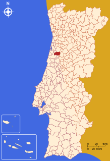
Santa Marta de Penaguião is a Portuguese municipality in the district of Vila Real, in the northern region of Douro. The population in 2011 was 7,356, in an area of 69.28 km².

Maia is a civil parish in the municipality of Ribeira Grande in the Portuguese archipelago of the Azores. The population in 2011 was 1,900, in an area of 21.97 km². Maia is the largest parish by area in Ribeira Grande.
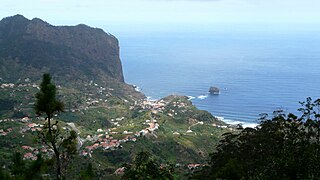
Porto da Cruz (Portuguese pronunciation: [ˈpoɾtu dɐ ˈkɾuʃ], is a civil parish in the municipality of Machico in the northeastern corner of Madeira. The population in 2011 was 2,597, in an area of 25.22 km².

Alcanena is a municipality in Santarém District in Portugal. The population in 2011 was 13,868, in an area of 127.33 km².

Águeda is a city and a municipality in Portugal. The population in 2011 was 47,729, in an area of 335.27 km². The city proper had a population of 14,504 in 2001, while the remainder is distributed in 11 parishes, within the Baixo Vouga Subregion.
Anadia is a municipality in Portugal. The population in 2011 was 29,150, in an area of 216.63 km². It had 26,915 eligible voters. The city of Anadia is part of Arcos e Mogofores parish. The city itself had a population of 3,034 in 2001, while Arcos e Mogofores parish has about 5,000.
Moita is a municipality in the district of Setúbal in Portugal. The population in 2011 was 66,029, in an area of 55.26 km².

Batalha is a town and a municipality in Leiria District, Pinhal Litoral Subregion, Centro Region, Portugal. The town's name means battle. The municipality population in 2011 was 15,805, in an area of 103.42 square kilometres (39.93 sq mi). The town proper has about 7,500 inhabitants. The municipality is limited to the North and West by the municipality of Leiria, to the East by Ourém, to the Southeast by Alcanena and to the Southwest by Porto de Mós.

Tarrafal is a concelho (municipality) of Cape Verde. It is situated in the northern part of the island of Santiago. Its seat is the town Tarrafal. Its population was 18,565 at the 2010 census, and its area is 120.8 km2.

Lourinhã is a municipality in the District of Lisbon, in subregion Oeste in Portugal. The population in 2011 was 25,735, in an area of 147.17 km². The seat of the municipality is the town of Lourinhã, with a population of 8,800 inhabitants.

Pego is a civil parish (freguesia) in the municipality (concelho) of Abrantes, in the historic Portuguese district of Santarém. The population in 2011 was 2,431, in an area of 36.05 square kilometres (13.92 sq mi).

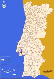
Almancil is a town and freguesia in the Loulé Municipality, in the affluent Golden Triangle region of the Algarve of southern Portugal. Almancil is known for its three Michelin star restaurants, the most of any town in the Algarve.

Amora is a civil parish, in the municipality of Seixal in the district of Setúbal, Portugal. It is part of the Lisbon Metropolitan Area. The population in 2011 was 48,629, in an area of 24.36 km².

Louriçal is a Portuguese freguesia of Pombal municipality. The population in 2011 was 4,645, in an area of 47.66 km².
Agrobom is a former civil parish, located in the municipality of Alfândega da Fé, in northern Portugal. In 2013, the parish merged into the new parish Agrobom, Saldonha e Vale Pereiro. It has less than 150 inhabitants in an area of 14.97 km² against the flank of the Serra de Bornes.


