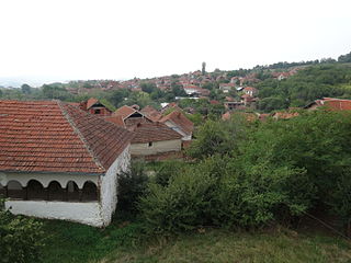
Mojinci | |
---|---|
Village | |
Country | |
District | Pirot District |
Municipality | Dimitrovgrad |
Population (2002) | |
• Total | 34 |
Time zone | CET (UTC+1) |
• Summer (DST) | CEST (UTC+2) |
Mojinci is a village in the municipality of Dimitrovgrad, Serbia. According to the 2002 census, the village has a population of 34 people. [1]
A village is a clustered human settlement or community, larger than a hamlet but smaller than a town, with a population ranging from a few hundred to a few thousand. Though villages are often located in rural areas, the term urban village is also applied to certain urban neighborhoods. Villages are normally permanent, with fixed dwellings; however, transient villages can occur. Further, the dwellings of a village are fairly close to one another, not scattered broadly over the landscape, as a dispersed settlement.
Dimitrovgrad is a town and municipality located in the Pirot District of southeastern Serbia. According to 2011 census, the municipality of Dimitrovgrad has a population of 10,118 people and the town 6,278.
Serbia, officially the Republic of Serbia, is a country situated at the crossroads of Central and Southeast Europe in the southern Pannonian Plain and the central Balkans. The sovereign state borders Hungary to the north, Romania to the northeast, Bulgaria to the southeast, North Macedonia to the south, Croatia and Bosnia and Herzegovina to the west, and Montenegro to the southwest. The country claims a border with Albania through the disputed territory of Kosovo. Serbia's population is about seven million. Its capital, Belgrade, ranks among the oldest and largest citiеs in southeastern Europe.
The Porticus Octaviae is an ancient structure in Rome. The colonnaded walks of the portico enclosed the temples of Jupiter Stator and Juno Regina, as well as a library. The structure was used as a fish market from the medieval period, and up to the end of 19th century.
Cypress Ridge High School is a public secondary school located in unincorporated Harris County, Texas. It was established in 2002 as Cypress-Fairbanks Independent School District High School #7. Cypress Ridge provides the deaf education program for Cy Fair ISD and surrounding school districts.
Maniaki is a village in the municipality Pylos–Nestoras, Messenia, Greece. It was the place where the Battle of Maniaki occurred on 1 June 1825.
Kangyidaunt Township is a township of the Pathein District in the Ayeyarwady Division of Myanmar. The principal town is Kangyidaut.
Młudzyn is a village in the administrative district of Gmina Żuromin, within Żuromin County, Masovian Voivodeship, in east-central Poland. It lies approximately 6 kilometres (4 mi) south of Żuromin and 116 km (72 mi) north-west of Warsaw.
Crkovnica is a village in the municipality of Leskovac, Serbia. According to the 2002 census, the village has a population of 133 people.
Donja Kupinovica is a village in the municipality of Leskovac, Serbia. According to the 2002 census, the village has a population of 97 people.
Donja Slatina is a village in the municipality of Leskovac, Serbia. According to the 2002 census, the village has a population of 300 people.
Golema Njiva is a village in the municipality of Leskovac, Serbia. According to the 2002 census, the village has a population of 118 people.
Gornja Kupinovica is a village in the municipality of Leskovac, Serbia. According to the 2002 census, the village has a population of 189 people.
Gornja Slatina is a village in the municipality of Leskovac, Serbia. According to the 2002 census, the village has a population of 210 people.
Jarsenovo is a village in the municipality of Leskovac, Serbia. According to the 2002 census, the village has a population of 428 people.
Jelašnica is a village in the municipality of Leskovac, Serbia. According to the 2002 census, the village has a population of 289 people.
Manojlovce is a village in the municipality of Leskovac, Serbia. According to the 2002 census, the village has a population of 778 people.
Oraovica is a village in the municipality of Leskovac, Serbia. According to the 2002 census, the village has a population of 152 people.
Orašac is a village in the municipality of Leskovac, Serbia. According to the 2002 census, the village has a population of 582 people.
Rajno Polje is a village in the municipality of Leskovac, Serbia. According to the 2002 census, the village has a population of 739 people.
Velika Biljanica is a village in the municipality of Leskovac, Serbia. According to the 2002 census, the village has a population of 516 people.
Mojsinje is a village in the municipality of Čačak, Serbia. According to the 2011 census, the village has a population of 836 people.
Kavaklı is a village in the District of Kahta, Adıyaman Province, Turkey.
Coordinates: 43°04′35″N22°53′33″E / 43.0764°N 22.8925°E
A geographic coordinate system is a coordinate system that enables every location on Earth to be specified by a set of numbers, letters or symbols. The coordinates are often chosen such that one of the numbers represents a vertical position and two or three of the numbers represent a horizontal position; alternatively, a geographic position may be expressed in a combined three-dimensional Cartesian vector. A common choice of coordinates is latitude, longitude and elevation. To specify a location on a plane requires a map projection.
This Pirot District, Serbia location article is a stub. You can help Wikipedia by expanding it. |