
Brazzaville is the capital and largest city of the Republic of the Congo. Administratively, it is a department and a commune. Constituting the financial and administrative centre of the country, it is located on the north side of the Congo River, opposite Kinshasa, the capital city of the Democratic Republic of the Congo.

The Democratic Republic of the Congo, also known as Congo-Kinshasa, Congo-Zaire, Congo DR, DR Congo, DRC, or simply either Congo or the Congo, is a country in Central Africa. By land area, the DRC is the second-largest country in Africa and the 11th-largest in the world. With a population of around 105 million, the Democratic Republic of the Congo is the most populous Francophone country in the world, and the fourth-largest in Africa. The national capital and largest city is Kinshasa, which is also the economic center. The country is bordered by the Republic of the Congo, Central African Republic, South Sudan, Uganda, Rwanda, Burundi, Tanzania, Zambia, Angola, the Cabinda exclave of Angola, and the South Atlantic Ocean.

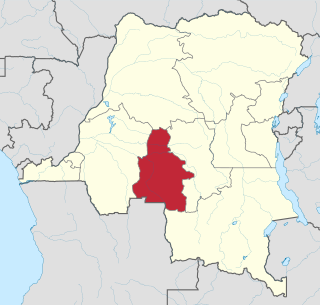
Bandundu is one of eleven former provinces of the Democratic Republic of the Congo. It bordered the provinces of Kinshasa and Bas-Congo to the west, Équateur to the north, and Kasai-Occidental to the east. The provincial capital is also called Bandundu.
Kasaï-Occidental was one of the eleven provinces of the Democratic Republic of the Congo between 1966 and 2015, when it was split into the Kasaï-Central and the Kasaï provinces.
Maniema Province is one of 26 provinces of the Democratic Republic of the Congo. Its capital is Kindu. The 2020 population was estimated to be 2,856,300.

Orientale Province is one of the former provinces of the Democratic Republic of the Congo and its predecessors the Congo Free State and the Belgian Congo. It went through a series of boundary changes between 1898 and 2015, when it was divided into smaller units.

Bukavu is a city in eastern Democratic Republic of the Congo (DRC), lying at the extreme south-western edge of Lake Kivu, west of Cyangugu in Rwanda, and separated from it by the outlet of the Ruzizi River. It is the capital of the South Kivu Province and as of 2012 it had an estimated population of 806,940.

Kisangani is the capital of Tshopo province in the Democratic Republic of the Congo. It is the fifth most populous urban area in the country, with an estimated population of 1,312,000 in 2021, and the largest of the cities that lie in the tropical woodlands of the Congo.

The Second Congo War, also known as Africa's World War, the Great War of Africa, or the Great African War, began in the Democratic Republic of the Congo on 2 August 1998, little more than a year after the First Congo War, and involved some of the same issues.

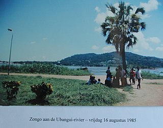
Likouala is a department of the Republic of the Congo in the northern part of the country. It borders the departments of Cuvette and Sangha, and internationally, the Democratic Republic of the Congo and the Central African Republic. The region has an area of 66,044 km² and an estimated population of almost 360,000. The chief town is Impfondo. Principal cities and towns include Epena and Dongou.

Kivu was the name for a large "region" in the Democratic Republic of the Congo under the rule of Mobutu Sese Seko that bordered Lake Kivu. It included three "Sub-Regions" : Nord-Kivu, Sud-Kivu and Maniema, corresponding to the three current provinces created in 1986. The capital of the Kivu Region was in Bukavu, and the capitals of the three Sub-Regions were in Goma, Uvira and Kindu.

Ituri Province is one of the 21 new provinces of the Democratic Republic of the Congo created in the 2015 repartitioning. Ituri, Bas-Uele, Haut-Uele, and Tshopo provinces are the result of the subdividing of the former Orientale province. Ituri was formed from the Ituri district whose town of Bunia was elevated to capital city of the new province.
Kananga, formerly known as Luluabourg or Luluaburg, is the capital city of the Kasai-Central Province in the Democratic Republic of the Congo and was the capital of the former Kasaï-Occidental Province. It is the fourth most populous urban area in the country, with an estimated population of 1,524,000 in 2021.
Beni is a city in north eastern Democratic Republic of the Congo, lying immediately west of the Virunga National Park and the Rwenzori Mountains, on the edge of the Ituri Forest.

Équateur is one of the 21 new provinces of the Democratic Republic of the Congo created in the 2015 repartitioning. Équateur, Mongala, Nord-Ubangi, Sud-Ubangi, and Tshuapa provinces are the result of the dismemberment of the former Équateur province. The new province was formed from the Équateur district and the independently administered city of Mbandaka which retained its status as a provincial capital.
Mufulira is a town in the Copperbelt Province of Zambia. Mufulira means "Place of Abundance and Peace". The town developed around the Mufulira Copper Mine in the 1930s. The town also serves as the administrative capital of Mufulira District.

Kindu is a city in the Democratic Republic of Congo, the capital of Maniema province. It has a population of about 200,000 and is situated on the Lualaba River at an altitude of about 500 metres, and is about 400 km west of Bukavu.

The Republic of the Congo, also known as Congo-Brazzaville, West Congo, Congo Republic, ROC, or simply either Congo or the Congo, is a country located on the western coast of Central Africa to the west of the Congo River. It is bordered to the west by Gabon, to the northwest by Cameroon, to the northeast by the Central African Republic, to the southeast by the Democratic Republic of the Congo, to the south by the Angolan exclave of Cabinda, and to the southwest by the Atlantic Ocean.
Sud-Ubangi is one of the 21 new provinces of the Democratic Republic of the Congo created in the 2015 repartitioning. It lies in the northwest of the country on the Ubangi River.
