| Mokpo Catholic University | |
| Hangul | |
|---|---|
| Hanja | |
| Revised Romanization | Mokpo Gatollik Daehakgyo |
| McCune–Reischauer | Mokp'o Kat'ollik Taehakkyo |
Mokpo Catholic University is a Catholic university located in Mokpo,South Korea.
| Mokpo Catholic University | |
| Hangul | |
|---|---|
| Hanja | |
| Revised Romanization | Mokpo Gatollik Daehakgyo |
| McCune–Reischauer | Mokp'o Kat'ollik Taehakkyo |
Mokpo Catholic University is a Catholic university located in Mokpo,South Korea.

South Jeolla Province,also known as Jeonnam,is a province in the Honam region,South Korea,and the southernmost province in mainland Korea. South Jeolla borders the provinces of North Jeolla to the north,South Gyeongsang to the northeast,and Jeju to the southwest in the Korea Strait.

Mokpo is the third largest and most densely populated city in South Jeolla Province,South Korea,located at the southwestern tip of the Korean Peninsula,close to Yudal mountain. Mokpo has frequent high-speed train services to Seoul,and is the terminus for a number of ferry routes serving islands in the adjacent Yellow Sea and Dadohae National Maritime Park.

Muan County (Muan-gun) is a county in South Jeolla Province (Jeollanam-do),South Korea. In 2005,Muan County became the capital of Jeollanam-do following the transfer of the provincial office from its previous location,Gwangju to the village of Namak in Muan. Muan International Airport was opened here,and will eventually replace the airports in Gwangju and Mokpo.

Yeongam is a city and county in South Jeolla Province,South Korea. Bordered with Mokpo and Naju to the north,Jangheung County to the east,and Haenam and Gangjin to the south,Yeongam County comprises two eups and nine myeons,populated with about 57,000 people,and its county hall is seated in Yeongam-eup.
Namak-ri is a small town in Samhyang-myeon,which is part of Muan County in South Jeolla province of South Korea. Namak-ri became the home of the South Jeolla provincial government following its move from the city of Gwangju in 2005.

Heuksando (Korean: 흑산도) is an island in the Yellow Sea located off 97.2 km from the southwest coast of Mokpo,Jeollanam-do,South Korea. It covers an area of 19.7 km2 and consists of several peaks:Munamsan,Gitdaebong,Seonyubong,Sangnasan. It is within the administrative boundaries of Sinan County,Jeollanam-do,South Korea since 1969. The island's 19.7 km2 are home to about 3,133 people.
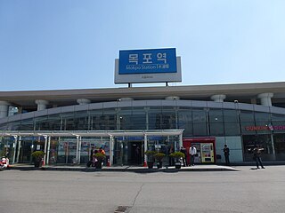
Mokpo station is a station on the Honam Line in Mokpo,South Jeolla Province. It is the westernmost railway station in South Korea. This station is the last stop on the Honam Line. Being located in the southwestern part of the Korean peninsula,it is used by customers who visit Jeju Island,Heuksan Island,and Hong Island in connection with KTX.

The Mokpo International Football Center is a football-specific stadium and training ground in Mokpo,South Korea and was built in 2009. It has six football pitch. Two are nature grounds,three are artificial turf grounds and one ground for youth.
Mokpo National University is located in Muan and Mokpo,South Korea. Mokpo,located in the most southwestern region of Korea,is a key coastal city of the Korean Peninsula. The main campus is located in the valley of Seungdal Mountain,which has a beautiful view of the sea and the surrounding area.
Aphae Bridge connects Mokpo and Aphae island of Sinan county of South Jeolla province,South Korea. The project was first set up in June,2000 and the construction of the bridge was finalized in 2008. The whole bridge belongs to some part of national route 2 to cut down on discomforts by visiting Aphae area by ferries.
Daebul Industrial Complex is an industrial complex which covers a large portion of Samho,Yeongam of South Jeolla province in South Korea. The complex was initially designed to set up fundamental base for development in the Mokpo area. Finalized in December 1996,the residence of enterprises start from 1997. The complex was initially aimed at the south east Asia and China market.
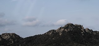
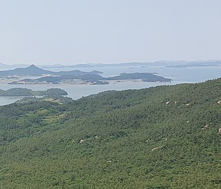
Yudal Mountain is a mountain located in Mokpo city,Jeollanam-do in South Korea. It is one of the "8 Scenes of Mokpo" and is a symbol of the city. At the summit,thousands of islands can be seen with several hills of strange looking rocks. The nickname of the mountain is Mountain Gaegol,which refers to Mountain Geumgang in North Korea during the summer. The three highest peaks are called first,second and madang bawi(rock). Two monuments are found on or near the mountain;the first is a statue of General Yi Sun-sin,the other is of a famous singer Lee Nan-young.

Gatbawi is a natural Sandstone and Tafoni formation found on the shore of Mokpo's east harbor,near the mouth of the Yeongsan River,South Jeolla Province,South Korea.
Maenggolgundo,also Maenggol Kundo,are an archipelago consisting of the three inhabited islands Jukdo (죽도),Maenggoldo (맹골도),and Gwakdo (곽도),and the uninhabited islets Myeongdo (명도),Mongdeokdo (몽덕도),and Sojukdo (소죽도).
The women's tournament of football at the 2015 Summer Universiade will be held from July 2 to 12 in Gwangju,South Korea.
The 2017 Korean FA Cup,known as the 2017 KEB Hana Bank FA Cup,was the 22nd edition of the Korean FA Cup. The champions Ulsan Hyundai qualified for the group stage of the 2018 AFC Champions League. This edition introduced video assistant referee (VAR) system for the first time in Korean FA Cup history,using in the semi-finals and the final.
The 2018 Korean FA Cup,known as the 2018 KEB Hana Bank FA Cup,was the 23rd edition of the Korean FA Cup. Daegu FC qualified for the group stage of the 2019 AFC Champions League after becoming eventual champions.
The 2019 Korean FA Cup,known as the 2019 KEB Hana Bank FA Cup,was the 24th edition of the Korean FA Cup.
Amtaedo is the sixth largest island in Sinan County,South Jeolla Province,South Korea. The island lies in the Yellow Sea about 25 km west of Mokpo,South Jeolla Province,South Korea. The highest peak on Amtaedo is Seungbong mountain (승봉산),which stands at 355 meters above sea level. In the past it was only possible travel to Amtaedo by a ferry departing from the Mokpo Coast Ferry Terminal. However,on April 4,2019 the Angel Bridge (천사대교) was completed connecting Amtaedo with the island of Aphaedo (압해도). Since Aphaedo is connected to the mainland by two bridges,it is now possible to drive to Amtaedo by car. The neighboring islands of Jaeundo (자은도),Palgeumdo (팔금도) and Chupodo (추포도) are connected to Amtaedo by bridges.
34°49′36″N126°25′09″E / 34.8268°N 126.4192°E
| | This article about a South Korean institution of tertiary education is a stub. You can help Wikipedia by expanding it. |