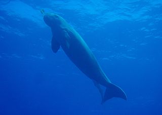
The dugong is a marine mammal. It is one of four living species of the order Sirenia, which also includes three species of manatees. It is the only living representative of the once-diverse family Dugongidae; its closest modern relative, Steller's sea cow, was hunted to extinction in the 18th century.

The Great Barrier Reef is the world's largest coral reef system, composed of over 2,900 individual reefs and 900 islands stretching for over 2,300 kilometres (1,400 mi) over an area of approximately 344,400 square kilometres (133,000 sq mi). The reef is located in the Coral Sea, off the coast of Queensland, Australia, separated from the coast by a channel 160 kilometres (100 mi) wide in places and over 61 metres (200 ft) deep. The Great Barrier Reef can be seen from outer space and is the world's biggest single structure made by living organisms. This reef structure is composed of and built by billions of tiny organisms, known as coral polyps. It supports a wide diversity of life and was selected as a World Heritage Site in 1981. CNN labelled it one of the Seven Natural Wonders of the World in 1997. Australian World Heritage places included it in its list in 2007. The Queensland National Trust named it a state icon of Queensland in 2006.

Brisbane Water National Park is a national park on the Central Coast of New South Wales, Australia. The national park is situated 70 kilometres (43 mi) north of Sydney and 12 kilometres (7.5 mi) southwest of Gosford. It consists the Brisbane Water and Mooney Mooney Creek waterways.
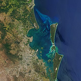
Moreton Bay is a bay located on the eastern coast of Australia 14 kilometres (8.7 mi) from central Brisbane, Queensland. It is one of Queensland's most important coastal resources. The waters of Moreton Bay are a popular destination for recreational anglers and are used by commercial operators who provide seafood to market.

A marine park is a designated park consisting of an area of sea set aside to achieve ecological sustainability, promote marine awareness and understanding, enable marine recreational activities, and provide benefits for Indigenous peoples and coastal communities. Most marine parks are managed by national governments, and organized like 'watery' national parks, whereas marine protected areas and marine reserves are often managed by a subnational entity or non-governmental organization, such as a conservation authority.
The Kimberley is the northernmost of the nine regions of Western Australia. It is bordered on the west by the Indian Ocean, on the north by the Timor Sea, on the south by the Great Sandy and Tanami deserts in the region of the Pilbara, and on the east by the Northern Territory.
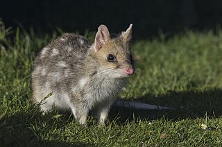
Quolls are carnivorous marsupials native to Australia and New Guinea. They are primarily nocturnal and spend most of the day in a den. Of the six species of quoll, four are found in Australia and two in New Guinea. Another two species are known from fossil remains in Pliocene and Pleistocene deposits in Queensland. Genetic evidence indicates that quolls evolved around 15 million years ago in the Miocene, and that the ancestors of the six species had all diverged by around four million years ago. The six species vary in weight and size, from 300 g (11 oz) to 7 kg (15 lb). They have brown or black fur and pink noses. They are largely solitary, but come together for a few social interactions such as mating which occurs during the winter season. A female gives birth to up to 30 pups, but the number that can be raised to adulthood is limited by the number of teats (6–7). They have a life span of 1–5 years.

Magnetic Island is an island 8 kilometres (5 mi) offshore from the city of Townsville, Queensland, Australia. This 52 km2 (20.1 sq mi) mountainous island in Cleveland Bay has effectively become a suburb of Townsville. The island is accessible from Townsville Breakwater to Nelly Bay Harbour by ferry. There is a large 39.5 km2 (15.3 sq mi) National Park and bird sanctuary and walking tracks can be taken between the populated bays and to a number of tourist destinations such as the World War II forts.

The northern quoll, also known as the northern native cat, the North Australian native cat or the satanellus is a carnivorous marsupial native to Australia.

The Yorke Peninsula, known as Guuranda by the original inhabitants, the Narungga people, is a peninsula located northwest and west of Adelaide in South Australia, between Spencer Gulf on the west and Gulf St Vincent on the east. The peninsula is separated from Kangaroo Island to the south by Investigator Strait.

Far North Queensland (FNQ) is the northernmost part of the Australian state of Queensland. Its largest city is Cairns and it is dominated geographically by Cape York Peninsula, which stretches north to the Torres Strait, and west to the Gulf Country. The waters of Torres Strait include the only international border in the area contiguous with the Australian mainland, between Australia and Papua New Guinea.

The Ningaloo Coast is a World Heritage Site located in the north west coastal region of Western Australia. The 705,015-hectare (1,742,130-acre) heritage-listed area is located approximately 1,200 kilometres (750 mi) north of Perth, along the East Indian Ocean. The distinctive Ningaloo Reef that fringes the Ningaloo Coast is 260 kilometres (160 mi) long and is Australia's largest fringing coral reef and the only large reef positioned very close to a landmass. The Muiron Islands and Cape Farquhar are within this coastal zone.

The Lacepede Islands, sometimes referred to simply as the Lacepedes, are a group of four islands lying off the Kimberley coast of Western Australia, about 120 kilometres north of Broome.

The Australian Wildlife Conservancy (AWC) is an independent Australian nonprofit organisation, working to conserve threatened wildlife and ecosystems in Australia. AWC is the largest private owner and manager of land for conservation in Australia, currently managing 31 sanctuaries and partnership sites for wildlife conservation that cover over 6.5 million hectares of land across Australia. It partners with governmental agencies, Indigenous groups, and private landholders to manage landscapes for effective conservation. Most funding comes from private support in the form of tax-deductible donations from the public, as well as some government grants for particular purposes, such as from the Australian government's National Reserve System Program.

Camden Sound is a relatively wide body of water in the Indian Ocean located in the Kimberley region of Western Australia. The Sound is bounded by the Bonaparte Archipelago to the north-east, the Buccaneer Archipelago to the south-west, and Montgomery Reef to the south.
Bigge Island is an island off the coast of the Kimberley region in Western Australia, within the Shire of Wyndham-East Kimberley.

The geography of Queensland in the north-east of Australia, is varied. It includes tropical islands, sandy beaches, flat river plains that flood after monsoon rains, tracts of rough, elevated terrain, dry deserts, rich agricultural belts and densely populated urban areas.
Boongaree Island is located off the Kimberley coast of Western Australia.
Uwins Island is located off the Kimberley coast of Western Australia.
Champagny Island, known to the traditional owners as Nimenba, is an island off the coast of the Kimberley region in Western Australia.