
Oracle is a census-designated place (CDP) in Pinal County, Arizona, United States. The population was 3,686 at the 2010 Census, falling to 3,051 at the 2020 Census.

The Southwestern United States, also known as the American Southwest or simply the Southwest, is a geographic and cultural region of the United States that includes Arizona and New Mexico, along with adjacent portions of California, Colorado, Nevada, Oklahoma, Texas, and Utah. The largest cities by metropolitan area are Phoenix, Las Vegas, El Paso, Albuquerque, and Tucson. Before 1848, in the historical region of Santa Fe de Nuevo México as well as parts of Alta California and Coahuila y Tejas, settlement was almost non-existent outside of Nuevo México's Pueblos and Spanish or Mexican municipalities. Much of the area had been a part of New Spain and Mexico until the United States acquired the area through the Treaty of Guadalupe Hidalgo in 1848 and the smaller Gadsden Purchase in 1854.

The Sonoran Desert is a hot desert and ecoregion in North America that covers the northwestern Mexican states of Sonora, Baja California, and Baja California Sur, as well as part of the Southwestern United States. It is the hottest desert in Mexico. It has an area of 260,000 square kilometers (100,000 sq mi).

The Verde River is a major tributary of the Salt River in the U.S. state of Arizona. It is about 170 miles (270 km) long and carries a mean flow of 602 cubic feet per second (17.0 m3/s) at its mouth. It is one of the largest perennial streams in Arizona.

The Santa Catalina Mountains, commonly referred to as the Catalina Mountains or the Catalinas, are north and northeast of Tucson in Arizona, United States, on Tucson's north perimeter. The mountain range is the most prominent in the Tucson area, with the highest average elevation. The highest point in the Catalinas is Mount Lemmon at an elevation of 9,157 feet (2,791 m) above sea level and receives 18 inches (460 mm) of precipitation annually.

Sabino Canyon is a significant canyon located in the Santa Catalina Mountains and the Coronado National Forest north of Tucson, Arizona, United States. Sabino Canyon is a popular recreation area for residents and visitors of Southern Arizona, providing a place to walk, hike or ride. Minutes away from the desert are large waterfalls along Sabino Creek with minor bridges constructed over them. Wildlife in the canyon includes a range of animals. Some of which are deer, javelina, skunks, tortoises, rattlesnakes and mountain lions. Like most places in Arizona, there are also owls, and scorpion which are very common in Tucson hiking trails.
The Catalina Highway, officially the General Hitchcock Highway, is the popular name for a Forest Highway and scenic route located in Pima County in southern Arizona. Also known as the Sky Island Scenic Byway, the Mount Lemmon Highway and Arizona Forest Highway 39, the Catalina Highway is the only paved roadway providing access to the resort village of Summerhaven as well as various recreational and scientific facilities located near the summit of Mount Lemmon. Ascending from the desert floor in Tucson to near the summit of Mount Lemmon, the short highway gains over 6,000 ft (1,800 m), showcasing a variety of climates ranging from lowland desert to alpine forests. The name sky island comes from the analogy of these mountains being like islands of forest in a sea of desert. It is designated as a scenic byway by the National Scenic Byways Program. and an Arizona Scenic Road by the Federal Highway Administration.

The following is an alphabetical list of articles related to the U.S. state of Arizona.

Pima Canyon is a major canyon located in the Santa Catalina Mountains, north of Catalina Foothills and Tucson, Arizona, US. Pusch Ridge forms the northwestern cliffs of Pima Canyon, dramatically rising from Pima Creek on the canyon floor. Pima Canyon varies greatly in elevation, from 2,900 feet (880 m) above sea level at Pima Creek to 6,350 feet (1,940 m) at Pima Saddle. Mount Kimball is the highest peak in the vicinity of the canyon.

The Salmon River is a 33.5-mile (53.9 km) river in the Cascade Range in the U.S. state of Oregon that drains part of southwestern Mount Hood. The entire length of the river is a protected National Wild and Scenic River. Several portions are in protected wilderness. It is affluent to the Sandy River, a tributary of the Columbia River.

The Imnaha River is a 73.3-mile-long (118.0 km) tributary of the Snake River in the U.S. state of Oregon. Flowing generally east near the headwaters and then north through Wallowa County, the entire river is designated Wild and Scenic. It follows a geologic fault to the Snake River, and in addition to land in the Wallowa–Whitman National Forest and private land, its corridor includes parts of three special management areas: the Eagle Cap Wilderness, Hells Canyon National Recreation Area, and Hells Canyon Scenic Byway. The Imnaha flows by the unincorporated community of Imnaha, the only settlement along its course, and enters the Snake River roughly 4 miles (6 km) from the larger river's confluence with the Salmon River of Idaho and 192 miles (309 km) from its confluence with the Columbia River.

The Mazatzal Mountains are a mountain range in south central Arizona, about 30–45 miles northeast of the Phoenix metropolitan area. The origin of the name remains obscure but one possibility is that it is from the Nahuatl language meaning "place of the deer". The crest of the Mazatzals forms the county line between Maricopa County and Gila County. SR 87, the Beeline Highway, traverses the Mazatzals on its way to Payson. The highest peak is Mazatzal Peak at 7,903 feet (2,409 m). They also include the Four Peaks, with elevation 7,659 ft, 2,334 m; a prominent mountain and landmark of the eastern Phoenix area.
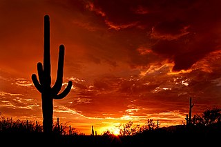
Saguaro National Park is a national park of the United States in southeastern Arizona. The 92,000-acre (37,000 ha) park consists of two separate areas—the Tucson Mountain District (TMD), about 10 miles (16 km) west of Tucson, and the Rincon Mountain District (RMD), about 10 miles (16 km) east of the city. Both districts preserve Sonoran Desert landscapes, fauna, and flora, including the giant saguaro cactus.
McWay Creek is a 2.5-mile-long (4.0 km) coastal stream in Monterey County in the U.S. state of California. It flows steeply west and south from McWay Canyon, high in California's Central Coast Range, and spills into the Pacific Ocean at Waterfall Cove after flowing over scenic McWay Falls. Most of the creek and its watershed are contained within Julia Pfeiffer Burns State Park, 12 miles (19 km) south of Pfeiffer Big Sur State Park. The creek is named after Christopher McWay from New York, a pioneer who homesteaded the property.

Havasu Creek is a stream in the U.S. state of Arizona. It is a tributary to the Colorado River, which it joins in the Grand Canyon. It primarily runs through the Havasupai Indian Reservation. It is sometimes called Cataract Creek, and should not be confused with Cataract Canyon, Utah.

The Poachie Range is a moderate length mountain range and massif in southeast Mohave County, Arizona, and the extreme southwest corner of Yavapai County; the range also abuts the northeast corner of La Paz County. The Poachie Range massif is bordered by the south-flowing Big Sandy River on its west, and the west-flowing Santa Maria River on its south; both rivers converge at the Poachie Range's southwest at Alamo Lake in Alamo Lake State Park.
The Date Creek Mountains is a short, arid range in southwest Yavapai County, Arizona. Congress is on its southeast foothills, and Wickenburg lies 15 mi (24 km) southeast.
The Peacock Mountains are a small, 26 mi (42 km) long mountain range in northwest Arizona, US. The range is a narrow sub-range, and an extension north, at the northeast of the Hualapai Mountains massif, which lies to the southwest. The range is defined by the Hualapai Valley to the northwest, and north and south-flowing washes on its east border, associated with faults and cliffs; the Cottonwood Cliffs are due east, and are connected to the Aquarius Cliffs southward at the west perimeter of the Aquarius Mountains; the cliffs are a result of the Aquarius Fault, which is an extension southward from the Grand Wash Cliffs and Grand Wash Fault which crosses the Colorado River at Lake Mead, and the west perimeter of the Grand Canyon/Colorado Plateau.

Ciénega Creek is an intermittent stream located in the Basin and Range region of southern Arizona, and is one of the most intact riparian corridors left in the state. It originates in the Canelo Hills and continues northwest about 50 miles (80 km) to an area just outside Tucson, where it becomes known as Pantano Wash. Pantano Wash continues through Tucson and eventually connects with the Rillito River.


 A sign at the Molino Canyon Vista
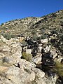 View of Molino Canyon from the Molino Canyon Vista
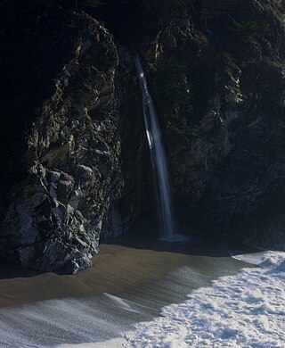
 A water pool and a small waterfall along Molino Creek

