Sabino Canyon

Last updated
Sabino Canyon
Sabino Canyon, 2002.jpg
The canyon in 2002
USA Arizona location map.svg
Red pog.svg
Sabino Canyon
Location in the state of Arizona
Geography
Location Santa Catalina Mountains, Arizona, United States
Coordinates 32°19′20.52″N110°48′35.36″W / 32.3223667°N 110.8098222°W / 32.3223667; -110.8098222 Coordinates: 32°19′20.52″N110°48′35.36″W / 32.3223667°N 110.8098222°W / 32.3223667; -110.8098222
Topo map Sabino Canyon, AZ
RiversSabino Creek

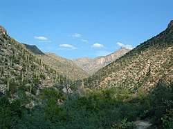
Sabino Canyon is a significant canyon located in the Santa Catalina Mountains and the Coronado National Forest north of Tucson, Arizona, United States. Sabino Canyon is a popular recreation area for residents and visitors of Southern Arizona, providing a place to walk, hike or ride. Minutes away from the desert are large waterfalls along Sabino Creek with minor bridges constructed over them. Wildlife in the canyon includes deer, javelina, skunks, tortoises, rattlesnakes and mountain lions.

Contents

History and formation

The history of Sabino Canyon began with the formation of the Santa Catalina Mountains over 12 million years ago. Around 5 million B.C., the mountains ceased formation around the Tucson valley. Present-day varieties of plant life first appeared between 6,000 and 8,000 years ago, and some of the earliest human occupants of Sabino Canyon were the Native American Hohokam people.

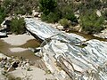
The 1887 Sonora earthquake dislodged massive boulders lining the canyon walls, which came to rest in the valley below. In 1905 the newly created U.S. Forest Service began administering Sabino Canyon. During the Great Depression, the Works Progress Administration (WPA) and Emergency Relief Administration (ERA) built Sabino Dam and nine bridges over Sabino Creek in an attempt to build a road to the top of Mount Lemmon. The road travels about 4.5 miles into the canyon, but was not completed due to the steep terrain at the end of the canyon.

Shuttle

The first Shuttle in Sabino Canyon began operating in October, 1978. From that point forward, access by cars was restricted to allow visitors to reach Upper Sabino Canyon by foot, bicycle or Shuttle. Sabino Canyon Tours was founded in May 1985 and provides visitors the opportunity to experience the noted beauty of Sabino Canyon. The Shuttle was cancelled by the current US government in 2018 and reopened in March 2019, with closed-in electric shuttlebuses set to replace the former open scenic Shuttles. Summer/Fall 2019 is expected to see the return of new open scenic Shuttle all electrically run.

Flooding

On July 31, 2006, flooding from a thunderstorm washed out the bridge at Rattlesnake Creek (just beyond mile marker 1 and shuttle stop #1), restricting the tram to the road below this point. Many portions of the roadway above Rattlesnake Creek also received damage from the flooding, including silt and debris scattered onto it. Tram service was completely restored, with the tram being able to complete all nine stops.

Funding

Federal funding has increasingly not kept pace with the pressures that urbanization and over a million visitors a year have placed on Sabino Canyon. Friends of Sabino Canyon, an independent non-profit organization, was founded in 1993 to raise additional funds to preserve and enhance Sabino Canyon.

Friends of Sabino Canyon has provided nearly $500,000 for projects in Sabino Canyon, including trail rehabilitation in the aftermath of the Aspen Fire, a water well, educational exhibits in the visitor center, new entrance plaza facilities, research into bats, amphibians and reptiles, and the restoration of the original Lowell House Ranger Station and the historic depression-era bridges and other stonework.

Friends of Sabino Canyon holds an outdoor holiday concert, Music in the Canyon, every year to raise funds for its work, and its major donors are recognized on hand-painted tiles at the entrance to Sabino Canyon, reflecting a variety of southwestern themes.

Sabino Canyon 20090214.jpg
Panorama looking toward Sabino Canyon in February 2009

See also

Related Research Articles

Bryce Canyon National Park National park in Utah, United States

Bryce Canyon National Park is an American national park located in southwestern Utah. The major feature of the park is Bryce Canyon, which despite its name, is not a canyon, but a collection of giant natural amphitheaters along the eastern side of the Paunsaugunt Plateau. Bryce is distinctive due to geological structures called hoodoos, formed by frost weathering and stream erosion of the river and lake bed sedimentary rocks. The red, orange, and white colors of the rocks provide spectacular views for park visitors. Bryce Canyon National Park is much smaller, and sits at a much higher elevation than nearby Zion National Park. The rim at Bryce varies from 8,000 to 9,000 feet.

Catalina Foothills, Arizona CDP in Pima County, Arizona

Catalina Foothills is an unincorporated community and census-designated place (CDP) located north of Tucson in Pima County, Arizona, United States. Situated in the southern foothills of the Santa Catalina Mountains, Catalina Foothills had a population of 50,796 at the 2010 census. Catalina Foothills is one of the most affluent communities in Arizona and in the U.S., with the 6th highest per capita income in Arizona, and the 14th highest per capita income in the U.S. of communities with a population of at least 50,000. The Catalina Foothills community includes some of Arizona's most expensive homes and land, and has the highest median property value. It also includes resorts, golf courses, and spas.

Capitol Reef National Park National park in Utah, United States

Capitol Reef National Park is an American national park in south-central Utah. The park is approximately 60 miles (97 km) long on its north–south axis and just 6 miles (9.7 km) wide on average. The park was established in 1971 to preserve 241,904 acres of desert landscape and is open all year, with May through September being the highest visitation months.

Santa Rita Mountains Landform in Pima and Santa Cruz counties, Arizona

The Santa Rita Mountains, located about 65 km (40 mi) southeast of Tucson, Arizona, extend 42 km (26 mi) from north to south, then trending southeast. They merge again southeastwards into the Patagonia Mountains, trending northwest by southeast. The highest point in the range, and the highest point in the Tucson area, is Mount Wrightson, with an elevation of 9,453 feet, The range contains Madera Canyon, one of the world's premier birding areas. The Smithsonian Institution's Fred Lawrence Whipple Observatory is located on Mount Hopkins. The range is one of the Madrean sky islands.

Cloudland Canyon State Park State park in Georgia, United States

Cloudland Canyon State Park is a 3,485 acres (14.10 km2) Georgia state park located near Trenton and Cooper Heights on the western edge of Lookout Mountain. One of the largest and most scenic parks in Georgia, it contains rugged geology, and offers visitors a range of vistas across the deep gorge cut through the mountain by Sitton Gulch Creek, where the elevation varies from 800 to over 1,800 feet. Views of the canyon can be seen from the picnic area parking lot, in addition to additional views located along the rim trail. At the bottom of the gorge, two waterfalls cascade across layers of sandstone and shale, ending in small pools below.

Coronado National Forest Managed forest in southern Arizona and New Mexico

The Coronado National Forest is a United States National Forest that includes an area of about 1.78 million acres (7,200 km2) spread throughout mountain ranges in southeastern Arizona and southwestern New Mexico.

Santa Catalina Mountains Mountain range in Pima and Pinal counties, Arizona, United States

The Santa Catalina Mountains, commonly referred to as the Catalina Mountains or the Catalinas, are north and northeast of Tucson in Arizona, United States, on Tucson's north perimeter. The mountain range is the most prominent in the Tucson area, with the highest average elevation. The highest point in the Catalinas is Mount Lemmon at an elevation of 9,157 feet (2,791 m) above sea level and receives 18 inches (46 cm) of precipitation annually.

Bear Canyon Landform in Pima County, Arizona

Bear Canyon, located in the Sabino Canyon recreation area of the Coronado National Forest near Tucson, Arizona, offers views of the Santa Catalina Mountains to the north. Accessible by tram or foot from the Sabino Canyon visitors' center, Bear Canyon contains such attractions as the seasonal Seven Falls and Thimble Peak.

Mount Lemmon Mountain in Arizona, United States

Mount Lemmon, with a summit elevation of 9,159 feet (2,792 m), is the highest point in the Santa Catalina Mountains. It is located in the Coronado National Forest north of Tucson, Arizona, United States. Mount Lemmon was named for botanist Sara Plummer Lemmon, who trekked to the top of the mountain with her husband and E. O. Stratton, a local rancher, by horse and foot in 1881. Mount Lemmon is also known as Babad Do'ag, or Frog Mountain to the Tohono O'odham. It is reported that Mount Lemmon Ski Valley, on the mountain's northeastern side, receives 200 inches (508 cm) of snow annually.

Pusch Ridge Mountains in Arizona, United States

Pusch Ridge is the most prominent feature in the Pusch Ridge Wilderness Area of the Santa Catalina Mountains, managed by the Coronado National Forest north of Tucson, Arizona, in the United States.

Rincon Mountains Mountain range in Arizona, United States

The Rincon Mountains are a significant mountain range east of Tucson, Pima County, Arizona, in the United States. The Rincon Mountains are one of five mountain ranges surrounding the Tucson valley. The other ranges include the most prominent, the Santa Catalina Mountains to the north, the Santa Rita Mountains to the south, the Tucson Mountains to the west, and the Tortolita Mountains to the northwest. Redington Pass separates the Rincon Mountains from the Santa Catalina Mountains. The Rincon Mountains are generally less rugged than the Santa Catalina Mountains and Santa Rita Mountains. The Rincon Mountains are also included in the Madrean sky island mountain ranges of southeast Arizona, extreme southwest New Mexico, and northern Sonora Mexico.

The Catalina Highway, officially the General Hitchcock Highway, is the popular name for a Forest Highway and scenic route located in Pima County in southern Arizona. Also known as the Sky Island Scenic Byway, the Mount Lemmon Highway and Arizona Forest Highway 39, the Catalina Highway is the only paved roadway providing access to the resort village of Summerhaven as well as various recreational and scientific facilities located near the summit of Mount Lemmon. Ascending from the desert floor in Tucson to near the summit of Mount Lemmon, the short highway gains over 6,000 ft (1.8 km), showcasing a variety of climates ranging from lowland desert to alpine forests. The name sky island comes from the analogy of these mountains being like islands of forest in a sea of desert. It is designated as a scenic byway by the National Scenic Byways Program. and an Arizona Scenic Road by the Federal Highway Administration.

Arizona Trail US National Scenic Trail

The Arizona National Scenic Trail is a National Scenic Trail from Mexico to Utah that traverses the whole north–south length of the U.S. state of Arizona. The trail begins at the Coronado National Memorial near the US–Mexico border and moves north through parts of the Huachuca, Santa Rita, and Rincon Mountains. The trail continues through the Santa Catalina north of Tucson and the Mazatzal Mountains before ascending the Mogollon Rim north of Payson, eventually leading to the higher elevations of Northern Arizona and the San Francisco Peaks. The trail then continues across the Coconino Plateau and in and out of the Grand Canyon. The Arizona Trail terminates near the Arizona–Utah border in the Kaibab Plateau region. The 800-mile (1,300 km) long Arizona Trail was completed on December 16, 2011. The trail is designed as a primitive trail for hiking, equestrians, mountain biking, and even cross country skiing, showcasing the wide variety of mountain ranges and ecosystems of Arizona.

Pima Canyon

Pima Canyon is a major canyon located in the Santa Catalina Mountains, north of Catalina Foothills and Tucson, Arizona, USA. Pusch Ridge forms the northwestern cliffs of Pima Canyon, dramatically rising from Pima Creek on the canyon floor. Pima Canyon varies greatly in elevation, from 2,900 feet (880 m) above sea level at Pima Creek to 6,350 feet (1,940 m) at Pima Saddle. Mount Kimball is the highest peak in the vicinity of the canyon.

Oak Creek Canyon

Oak Creek Canyon is a river gorge located in northern Arizona between the cities of Flagstaff and Sedona. The canyon is often described as a smaller cousin of the Grand Canyon because of its scenic beauty. State Route 89A enters the canyon on its north end via a series of hairpin turns before traversing the bottom of the canyon for about 13 miles (21 km) until the highway enters the town of Sedona.

Thimble Peak Landform in Pima County, Arizona

Thimble Peak is a well-known landmark in the Santa Catalina Mountains north of Tucson, Arizona. Thimble Peak rises from the foothills on the south side of the range. To its east is Bear Canyon, while to its west is Sabino Canyon. The peak is in the Pusch Ridge Wilderness on the Coronado National Forest.

Saguaro National Park National park in Arizona, United States

Saguaro National Park is an American national park in Pima County, southeastern Arizona. The 92,000-acre (37,000 ha) park consists of two separate areas—the Tucson Mountain District (TMD) about 10 miles (16 km) west of the city of Tucson and the Rincon Mountain District (RMD) about 10 miles (16 km) east of the city—that preserve Sonoran Desert landscapes, fauna, and flora, including the giant saguaro cactus.

Carr Peak Landform in Cochise County, Arizona

Carr Peak is the third-highest mountain in Cochise County, Arizona and is the second-highest mountain in the Huachuca Mountains. It rises about 10 miles (16 km) south of Sierra Vista, Arizona. The summit is in the Miller Peak Wilderness on the Coronado National Forest and about 4 miles (6 km) south of the Nature Conservancy's Ramsey Canyon Preserve. The area is well known among birders because of the variety of hummingbird species seen in the area as well as the dozens of southwestern specialties such as Apache pine, Chihuahua pine, ridge-nosed rattlesnake, lesser long-nosed bat and elegant trogon.

Canyon Ranch is a luxury wellness lifestyle brand that operates two destination health spa resorts and one retreat property in the United States. Canyon Ranch resorts are located in Tucson, Arizona, and Lenox, Massachusetts; its retreat property is located in Woodside, California. Canyon Ranch also operates Spa + Fitness locations with primarily day spa facilities. These are located at The Venetian and the Palazzo hotels in Las Vegas, and on cruise lines including Cunard Line, Regent Seven Seas, Oceania and Celebrity.

Molino Canyon Valley in Pima County, Arizona

Molino Canyon is a steep-sided, boulder-strewn canyon in the Santa Catalina Mountains northeast of Tucson, Arizona, next to the Molino Basin Campground. The canyon is located within the Coronado National Forest, and encompasses a wide variety of flora and fauna, ranging from lush pine forest in the canyon's upper reaches to Sonoran Desert cactus forest in the lower reaches. Catalina Highway was cut into the western side of the lower part of the canyon.

References