
La Place Bellecour is a large square in the centre of Lyon, France, to the north of the Ainay district. Measuring 312 m by 200 m, it is one of the largest open squares in Europe, and the third biggest square in France, behind the Place des Quinconces in Bordeaux (126,000 m²) and the Place de la Concorde in Paris (86,400 m²). It is also the largest pedestrian square in Europe: vehicles are allowed in Places de la Concorde and des Quinconces.

The nine arrondissements of Lyon are the administrative divisions of the City of Lyon. Unlike the spiral pattern of the arrondissements of Paris, or the meandering pattern of those in Marseille, the layout in Lyon is more idiosyncratic. This is for historical reasons: following the annexation of the communes of La Guillotière, La Croix-Rousse and Vaise in 1852, the newly enlarged city was divided into 5 arrondissements, which originally spiralled out anticlockwise from the Hôtel de Ville ; however, as the city's population expanded, it became necessary to split certain arrondissements, giving rise to today's seemingly random pattern.

Lyon, also spelled in English as Lyons, is the third-largest city and second-largest urban area of France. It is located at the confluence of the rivers Rhône and Saône, about 470 km (292 mi) southeast of Paris, 320 km (199 mi) north of Marseille and 56 km (35 mi) northeast of Saint-Étienne.

The Jardin botanique de Lyon, also known as the Jardin botanique du Parc de la Tête d'Or, is an 8 hectares municipal botanical garden located in the Parc de la Tête d'or in the 6th arrondissement of Lyon, France. It is open weekdays without charge.
Laënnec is a quarter of the 8th arrondissement of Lyon, in France. It is served by the eponymous station of the Line D of the Lyon Metro, which was opened on 11 December 1992 and had 132,316 passengers per month in 2006. Notable monuments of the quarter are the Grand Mosque of Lyon, located in the Boulevard Pinel, the Faculty of Medicine, the Faculty of Dentistry and the Maison des jeunes et de la culture.

The 8th arrondissement of Lyon is one of the 9 arrondissements of Lyon.
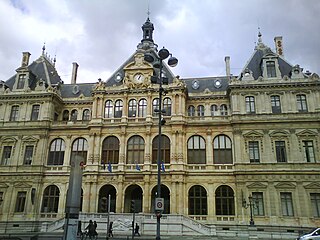
Les Cordeliers is one of the central quarters in the 2nd arrondissement of Lyon, France. It is mainly known for the Place des Cordeliers in its centre. Around the square, there are many notable monuments, including the Église Saint-Bonaventure and the Palais de la Bourse.

Rue Mercière is a street of Les Cordeliers quarter in the 2nd arrondissement of Lyon. From north to south, it connects the Place des Jacobins to the Place d'Albon. This street is served by metro stations Bellecour and Cordeliers of the line A and by the bus station Jacobins of the lines 91 and 99. It belongs to the zone classified as World Heritage Site by UNESCO.

The Place de la République is a square located in the Bellecour quarter, in the 2nd arrondissement of Lyon. It belongs to the zone classified as World Heritage Site by UNESCO.

The Place Ampère is a pedestrian square located in the Ainay square, in the 2nd arrondissement of Lyon. It is nearly the middle of the rue Victor-Hugo and is served by the metro station Ampère - Victor Hugo.

The Place Carnot is a square located in the Perrache quarter, in the 2nd arrondissement of Lyon.

The Cours Charlemagne is a large central street located in the Perrache quarter, in the 2nd arrondissement of Lyon. This street is dedicated to Charlemagne, who came several times to Lyon. In addition, the bishop Leidrade represented the emperor in the city and by his great work of reconstruction. The Cours Charlemagne begins Place des Archives, just at the south of the vaults of the interchange of Perrache. It ends on the Quai Perrache, which overlooks the Pont Pasteur.

The Rue Lainerie is an ancient cobbled pedestrian street of the Vieux Lyon quarter, in the 5th arrondissement of Lyon. From north to south, it connects two quarters, Saint-Paul and Saint-Jean, and more precisely the Place du Change and the Place Saint-Paul. There is currently an academy of music at No. 1 and many hotels. The street is served by many buses (29-30-31-44-184), two metro stations and a velo'v station. It belongs to the zone classified as World Heritage Site by UNESCO.

The Rue du Bœuf is a 188-metre cobbled pedestrian street of the Vieux Lyon quarter, located in the 5th arrondissement of Lyon. Very representative of the Renaissance architecture of the neighborhood, it is lined only with old houses from the 16th or 17th century. The street connects the rue de Gadagne which it continues after the Place du Petit Collège and the intersection of the rue du Chemin Neuf, the rue de la Bombarde and the rue Tramassac which prolongs it. The street belongs to the zone classified as World Heritage Site by UNESCO.

The Place Benoît-Crépu is a stone-paved square, located in Saint-Georges quarter, on the banks of the Saône, in the 5th arrondissement of Lyon. It has fountains with dolphin heads, many benches and trees and a playground. The place belongs to the area classified as World Heritage Site by UNESCO.

The Rue de l'Université is a large street in the 7th arrondissement of Lyon which connects the Pont de l'Université and the Avenue Jean-Jaurès. It is extended to the east by the rue Marc Bloch then the route de Vienne. It was named after the presence of several university buildings, built from 1884 until the late nineteenth century.

The Rue de Gadagne is a paved pedestrian street of the Saint-Jean quarter, in the 5th arrondissement of Lyon. It extends the rue du Bœuf and ends on the rue Lainerie that leads itself to the Place Saint-Paul. It is located in the center of Vieux Lyon and is part to the area which includes a mosaic of squares : Place du Change, Place du Petit Collège and Place de la Baleine in the extension of rue Saint-Jean. The street belongs to the zone classified as World Heritage Site by UNESCO. It is served by buses 29-30-31-44-184, a metro station and three velo'v stations.

Brotteaux is a neighborhood in the 6th arrondissement of Lyon. It is situated between the Rhône and the track railway which leads to the Gare de la Part-Dieu. The urbanization of this area began in the late eighteenth century under the leadership of architect and urban planner Jean-Antoine Morand Jouffrey (1727-1794). The area is sometimes called Morand quarter.

The Place Croix-Paquet is a square located in the 1st arrondissement of Lyon, in the pentes de la Croix-Rousse quarter. It is formed by the intersection of the rue du Griffon, the rue des Capucins and the montée Saint-Sébastien. The square belongs to the zone classified World Heritage Site by UNESCO.

Place Ambroise-Courtois is a square in the neighborhood of Monplaisir in the 8th arrondissement of Lyon. It was named after Ambroise Courtois, a city councillor, on 30 October 1944, months after Courtois was assassinated by the Milice française. It had been previously named Place de Monplaisir. The square is bordered by Avenue des Frères-Lumière to the south and Cours Albert-Thomas to the north.
