
Provence is a geographical region and historical province of southeastern France, which extends from the left bank of the lower Rhône River to the west to the Italian border to the east, and is bordered by the Mediterranean Sea to the south. It largely corresponds with the modern administrative région of Provence-Alpes-Côte d'Azur, and includes the départements of Var, Bouches-du-Rhône, Alpes-de-Haute-Provence and parts of Alpes-Maritimes and Vaucluse. The largest city of the region is Marseille.
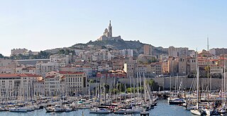
Bouches-du-Rhône is a department in Southern France named after the mouth of the river Rhône. It is the most populous department of the Provence-Alpes-Côte d'Azur region with 2,019,717 inhabitants in 2016; it has an area of 5,087 km2 (1,964 sq mi). Its INSEE and postal code is 13. Marseille is Bouches-du-Rhône's largest city and prefecture.

Tourism in France directly contributed 77.7 billion euros to gross domestic product, 30% of which comes from international visitors and 70% from domestic tourism spending. The total contribution of travel and tourism represents 9.7% of GDP and supports 2.9 million jobs in the country. Tourism contributes significantly to the balance of payments.

Mont Ventoux is a mountain in the Provence region of southern France, located some 20 km northeast of Carpentras, Vaucluse. On the north side, the mountain borders the Drôme département. At 1,909m, it is the highest mountain in the region and has been nicknamed the "Beast of Provence", the "Giant of Provence", or "The Bald Mountain". It has gained fame through its inclusion in the Tour de France cycling race; in 2009 it was the scene of the first penultimate-day mountain top finish in the Tour de France, with Alberto Contador sealing his yellow jersey.
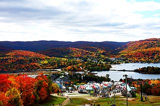
Mont Tremblant Ski Resort is a year-round resort in the Laurentian Mountains of Quebec, Canada, located about 130 km (80 mi) northwest of Montreal. It is best known as a ski destination, but also features Lake Tremblant suitable for swimming and two golf courses in the summer months. The name of the mountain, Mont Tremblant, was derived from the Algonquin indigenous people, who called it the "trembling mountain." The summit is at an elevation of 875 m (2,871 ft), which makes it one of the tallest peaks in the Laurentians. The resort is owned by Alterra Mountain Company.

Mont Aiguille is a mountain in the Vercors Plateau of the French Prealps, located 58 km (36 mi) south of Grenoble, in the commune of Chichilianne, and the département of Isère. The mountain, known as one of the Seven Wonders of Dauphiné, is a relatively flat limestone mesa surrounded by steep cliffs. The mountain lies within an area designated in 1970 as the Vercors Regional Natural Park. Mont Aiguille's limestone cliffs, especially on the northwest side, are popular with climbers. Its first climb in 1492 was said to mark the birth of mountaineering.
Mount Ascutney is a monadnock located in southern Vermont. With a summit elevation of about 3144 feet, it is the second-highest peak in Windsor County, Vermont. Particularly noteworthy about Ascutney are its granite outcrops, one of which, near its peak, serves as a launching point for hang-gliders. The mountain is very steep, and its trails traverse a Vermont state forest.

Gaston Rébuffat was a well-known French alpinist and mountain guide. The climbing technique gaston was named after him. He was a recipient of France's prestigious Chevalier de la Légion d'Honneur in 1984.

Castle Mountain is a mountain located within Banff National Park in the Canadian Rockies, approximately halfway between Banff and Lake Louise. It is the easternmost mountain of the Main Ranges in the Bow Valley and sits astride the Castle Mountain Fault which has thrust older sedimentary and metamorphic rocks forming the upper part of the mountain over the younger rocks forming its base. The mountain's castellated, or castle-like, appearance is a result of erosive processes acting at different rates on the peak's alternating layers of softer shale and harder limestone, dolomite and quartzite.

A calanque is a narrow, steep-walled inlet that is developed in limestone, dolomite, or other carbonate strata and found along the Mediterranean coast. A calanque is a steep-sided valley formed within karstic regions either by fluvial erosion or the collapse of the roof of a cave that has been subsequently partially submerged by a rise in sea level.

Gordes is a commune in the Vaucluse département in the Provence-Alpes-Côte d'Azur region in southeastern France. The residents are known as Gordiens. The nearest big city is Avignon; smaller cities nearby include Cavaillon, L'Isle-sur-la-Sorgue and Apt.

The Calanque de Sugiton is one of the numerous Calanques located between Marseille and Cassis, France.

Tumbledown Mountain is a mountain in Franklin County, Maine. The mountain is a popular hiking spot in western Maine, with trailheads located on Byron Road in unincorporated Township 6, north of Weld. It is distinguished by an alpine pond just below the summit. Tumbledown Mountain is also located near Coos Canyon, a mountain stream. Tumbledown offers trails of varying difficulty for different hikers.

Sugarloaf Mountain or Mount Sugarloaf, is a butte-like mountain located in South Deerfield, Massachusetts, United States, with two summits, North Sugarloaf Mountain 791 ft (241 m) and its more popular knee, South Sugarloaf Mountain 652 ft (199 m). Its cliffs, made of arkose sandstone, are a very prominent landscape feature visible for miles. Despite low elevations relative to the Berkshire Mountains to the west, dramatic cliff faces and a rise of 500 feet (150 m) to 600 feet (180 m) from the nearby Connecticut River make the mountain a popular tourist and hiking destination. Sugarloaf Mountain is the southern terminus of the Pocumtuck Range.

The Marseille-Cassis Classique Internationale is an annual half marathon which follows a course from Marseille to Cassis in France during the last weekend in October. It has the silver label of the IAAF Road Race Label Events and is thus among the ten more prestigious half marathon races in the world. First organised by the SCO Sainte-Marguerite sports club in 1979, the event has grown into a large international competition, with around 20,000 runners competing every year. The course distance of 20,308 metres falls slightly short of the true half marathon distance (21,097.5 m). Since 2012, the course has been shortened by 308 metres so the total distance of the course became exactly 20 kilometres. Still, the race is made more difficult by a long 327 m rise up a hill—the Col de la Gineste—at the midpoint of the course, which eventually follows back down into the port of Cassis. The annual race is usually held in the month of October.

The 9th arrondissement of Marseille is one of 16 districts or arrondissement of Marseille. This district is the largest in the city. The 9th district borders the 7th and 8th and the general region is known to be very prestigious.

KEDGE Business School is a French business school and grande école. Located in Marseille, Bordeaux, Toulon and Paris plus two campuses in China the school is a merger between two business schools: BEM and Euromed. Following the merger, Kedge is the largest business school in France. It is consistently ranked near the top 10 business schools in France by the Financial Times and is the one of the best 30 business schools in Europe, according to the Financial Times 2014. Nationally, it ranks 3rd for its MBA, 3rd for its budget, 2nd for research and is accredited by Palmes League as TOP business school with significant international influence. The institution also holds the Triple accreditation. The Global Executive MBA from Kedge Business School is now ranked n°22 worldwide, one place up from last year, the KEDGE BS Global Executive MBA pursues its progress in the Top 25 of the 2016 Financial Times Executive MBA ranking. In seven years, it has moved up 62 places in this reference ranking.
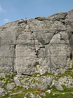
Ballyryan or Ballyreen is a small inland mostly west-facing limestone crag in The Burren in County Clare, Ireland. It is popular with rock climbers due to its easy access, the range of short easy-to-intermediate rock climbs, and its close proximity to the much larger and highly-regarded, Ailladie rock-climbing sea-cliff; Ailladie is also locally known as the Ballyreen Cliffs or Ballyreen Point.


