
Provence is a geographical region and historical province of southeastern France, which extends from the left bank of the lower Rhône to the west to the Italian border to the east; it is bordered by the Mediterranean Sea to the south. It largely corresponds with the modern administrative region of Provence-Alpes-Côte d'Azur and includes the departments of Var, Bouches-du-Rhône, Alpes-de-Haute-Provence, as well as parts of Alpes-Maritimes and Vaucluse. The largest city of the region and its modern-day capital is Marseille.
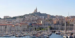
Bouches-du-Rhône is a department in southern France. It borders Vaucluse to the north, Gard to the west and Var to the east. The Mediterranean Sea lies to the south. Its prefecture and largest city is Marseille; other important cities include Aix-en-Provence, Arles, Martigues and Aubagne.

Prince of Orange is a title associated with the sovereign Principality of Orange, in what is now southern France and subsequently held by the stadtholders of, and then the heirs apparent of, the Netherlands.

Aubagne is a commune in the southern French department of Bouches-du-Rhône. In 2020, the commune was awarded three flowers by the National Council of Towns and Villages in Bloom in the Competition of cities and villages in Bloom.

A calanque is a narrow, steep-walled inlet that is developed in limestone, dolomite, or other carbonate strata and found along the Mediterranean coast. A calanque is a steep-sided valley formed within karstic regions either by fluvial erosion or the collapse of the roof of a cave that has been subsequently partially submerged by a rise in sea level.

Cassis is a commune situated east of Marseille in the department of Bouches-du-Rhône in the Provence-Alpes-Côte d'Azur region, whose coastline is known in English as the French Riviera, in Southern France.

The Cosquer Cave is located in the Calanque de Morgiou in Marseille, France, near Cap Morgiou. The entrance to the cave is located 37 m (121 ft) underwater, due to the Holocene sea level rise. The cave contains various prehistoric rock art engravings. Its submarine entrance was discovered in 1985 by Henri Cosquer, a professional diver. The underwater passage leading to the cave was progressively explored until 1990 by cave divers without the divers being aware of the archaeological character of the cave. It is only in the last period (1990–1991) of the progressive underwater explorations that the cave divers emerged in the non-submerged part of the cave. The prehistoric paintings were not immediately discovered by the divers to first emerge from the other side of the sump. The cave was named after Henri Cosquer, when its existence was made public in 1991, after three divers became lost in the cave and died.
Eble V of Ventadorn was viscount of Ventadour. He was the son of Eble IV and of Sybille de la Faye. His date of birth is unknown; he probably died soon after 1236.

Maria de Ventadorn was a patron of troubadour poetry at the end of the 12th century.
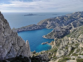
The Massif des Calanques is a wild and rugged terrain stretching from the ninth arrondissement of Marseille to the east towards Cassis, spanning 20 km in length and 4 km in width along the coast. Its highest peak is Mont Puget at 565m. The area has been protected by a national park since 2012.
The Baussenque Wars were a series of armed conflicts (1144–1162) between the House of Barcelona, then ruling in Provence, and the House of Baux. They are held up in Provence as the idealistic resistance by one of her native families against Catalan "occupation." In reality, they were the first of many successful expansions of Catalan power and influence in the Mediterranean world.
The House of Baux is a French noble family from the south of France. It was one of the richest and most powerful families of medieval Provence, known as the 'Race d’Aiglon'. They were independent lords as castellans of Les Baux and Arles and wielded very considerable authority at the local level. They held important fiefs and vast lands, including the principality of Orange.
William of Aumelas was the second son of William V of Montpellier and of Ermessende, daughter of count Peter of Melgueil. The lordship of Aumelas was detached from the territories of Montpellier to create a property for him.
William I of Baux was the Prince of Orange from 1182 until his death. He was an important Provençal nobleman.

Rudy Ricciotti is a French architect and publisher.
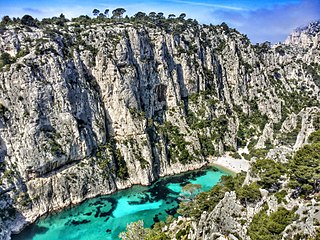
Calanques National Park is a French national park located on the Mediterranean coast in Bouches-du-Rhône, Southern France. It was established in 2012 and extends over 520 km2 (201 sq mi), of which 85 km2 (33 sq mi) is land, while the remaining is marine area. It includes parts of the Massif des Calanques stretching between Marseille's southern arrondissements, Cassis and La Ciotat. Some of the park's best known features include the Calanque de Sormiou, Calanque de Morgiou, Calanque de Port-Miou, Calanque de Sugiton, Calanque d'en Vau and Cosquer Cave.

Mazargues is a former village and now a neighbourhood of the 9th arrondissement in Marseille, Bouches-du-Rhône, France.
Guillaume de Littera (1371–1452) was a French Roman Catholic canon and provost in Aix-en-Provence as well as vicar in a diocese encompassing several localities in Provence. He became a large landowner after he inherited Meyreuil and Rousset.
Ralph III was the count of Valois from his father's death until his own. He was the second son of Walter II, count of Valois, Vexin and Amiens, and his wife Adela. His father died between 1017 and 1024, leaving Vexin and Amiens to Ralph's older brother Drogo of Mantes.

