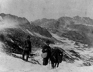
The Pike's Peak gold rush was the boom in gold prospecting and mining in the Pike's Peak Country of western Kansas Territory and southwestern Nebraska Territory of the United States that began in July 1858 and lasted until roughly the creation of the Colorado Territory on February 28, 1861. An estimated 100,000 gold seekers took part in one of the greatest gold rushes in North American history.

The Cheyenne are an Indigenous people of the Great Plains. Their Cheyenne language belongs to the Algonquian language family. Today, the Cheyenne people are split into two federally recognized nations: the Southern Cheyenne, who are enrolled in the Cheyenne and Arapaho Tribes in Oklahoma, and the Northern Cheyenne, who are enrolled in the Northern Cheyenne Tribe of the Northern Cheyenne Indian Reservation in Montana.

The Sand Creek massacre was a massacre of Cheyenne and Arapaho people by the U.S. Army in the American Indian Wars that occurred on November 29, 1864, when a 675-man force of the Third Colorado Cavalry under the command of U.S. Volunteers Colonel John Chivington attacked and destroyed a village of Cheyenne and Arapaho people in southeastern Colorado Territory, killing and mutilating an estimated 69 to over 600 Native American people. Chivington claimed 500 to 600 warriors were killed. However, most sources estimate around 150 people were killed, about two-thirds of whom were women and children. The location has been designated the Sand Creek Massacre National Historic Site and is administered by the National Park Service. The massacre is considered part of a series of events known as the Colorado Wars.

The region that is today the U.S. State of Colorado has been inhabited by Native Americans and their Paleoamerican ancestors for at least 13,500 years and possibly more than 37,000 years. The eastern edge of the Rocky Mountains was a major migration route that was important to the spread of early peoples throughout the Americas. The Lindenmeier site in Larimer County contains artifacts dating from approximately 8720 BCE.

The Territory of Colorado was an organized incorporated territory of the United States that existed from February 28, 1861, until August 1, 1876, when it was admitted to the Union as the State of Colorado.

The Powder River Expedition of 1865 also known as the Powder River War or Powder River Invasion, was a large and far-flung military operation of the United States Army against the Lakota Sioux, Cheyenne, and Arapaho Indians in Montana Territory and Dakota Territory. Although soldiers destroyed one Arapaho village and established Fort Connor to protect gold miners on the Bozeman Trail, the expedition is considered a failure because it failed to defeat or intimidate the Indians.

The Colorado War was an Indian War fought in 1864 and 1865 between the Southern Cheyenne, Arapaho, and allied Brulé and Oglala Sioux peoples versus the U.S. Army, Colorado militia, and white settlers in Colorado Territory and adjacent regions. The Kiowa and the Comanche played a minor role in actions that occurred in the southern part of the Territory along the Arkansas River. The Cheyenne, Arapaho, and Sioux played the major role in actions that occurred north of the Arkansas River and along the South Platte River, the Great Platte River Road, and the eastern portion of the Overland Trail. The United States government and Colorado Territory authorities participated through the 1st Colorado Cavalry Regiment, often called the Colorado volunteers. The war was centered on the Colorado Eastern Plains, extending eastward into Kansas and Nebraska.

William Wells Bent was a frontier trader and rancher in the American West, with forts in Colorado. He also acted as a mediator among the Cheyenne Nation, other Native American tribes and the expanding United States. With his brothers, Bent established a trade business along the Santa Fe Trail. In the early 1830s Bent built an adobe fort, called Bent's Fort, along the Arkansas River in present-day Colorado. Furs, horses and other goods were traded for food and other household goods by travelers along the Santa Fe trail, fur-trappers, and local Mexican and Native American people. Bent negotiated a peace among the many Plains tribes north and south of the Arkansas River, as well as between the Native American and the United States government.
The Treaty of Fort Wise of 1861 was a treaty entered into between the United States and six chiefs of the Southern Cheyenne and four of the Southern Arapaho Indian tribes. A significant proportion of Cheyennes opposed this treaty on the grounds that only a minority of Cheyenne chiefs had signed, and without the consent or approval of the rest of the tribe. Different responses to the treaty became a source of conflict between whites and Indians, leading to the Colorado War of 1864, including the Sand Creek Massacre.
Arapahoe County was a county of the extralegal United States Territory of Jefferson that existed from November 28, 1859, until February 28, 1861. The county name was also spelled Arapaho County, Arapahoe County, Arrapahoe County, and Arappahoe County. The county seat was Denver City.
The Overland Trail was a stagecoach and wagon trail in the American West during the 19th century. While portions of the route had been used by explorers and trappers since the 1820s, the Overland Trail was most heavily used in the 1860s as a route alternative to the Oregon, California, and Mormon trails through central Wyoming. The Overland Trail was famously used by the Overland Stage Company owned by Ben Holladay to run mail and passengers to Salt Lake City, Utah, via stagecoaches in the early 1860s. Starting from Atchison, Kansas, the trail descended into Colorado before looping back up to southern Wyoming and rejoining the Oregon Trail at Fort Bridger. The stage line operated until 1869 when the completion of the First transcontinental railroad eliminated the need for mail service via stagecoach.
The Battle of Julesburg took place on January 7, 1865, near Julesburg, Colorado between 1,000 Cheyenne, Arapaho, and Lakota Indians and about 60 soldiers of the U.S. army and 40 to 50 civilians. The Indians defeated the soldiers and over the next few weeks plundered ranches and stagecoach stations up and down the South Platte River valley.

Little Raven, also known as Hosa, was from about 1855 until his death in 1889 a principal chief of the Southern Arapaho Indians. He negotiated peace between the Southern Arapaho and Cheyenne and the Comanche, Kiowa, and Plains Apache. He also secured rights to the Cheyenne-Arapaho Reservation in Indian Territory.

South Platte Trail was a historic trail that followed the southern side of South Platte River from Fort Kearny in Nebraska to Denver, Colorado. Plains Indians, such as the Cheyenne and the Arapaho, hunted in the lands around the South Platte River. They also traded at trading posts along the route, as did white travelers. Travelers included trappers, traders, explorers, the military, and those following the gold rush. The trail was also used by the Pony Express.

Fort Wicked was a ranch and stage station on the Overland Trail from 1864 to 1868 in present-day Merino, Colorado. A historical marker commemorating the ranch is located at US 6 and CR-2.5. The ranch itself was located near a ford of the South Platte River, near where US-6 now crosses over the river. Fort Wicked was one of the few places along the trail to Denver that withstood an attack by Lakota, Cheyenne, and Arapaho Native Americans in the Colorado War of 1864. It was named Fort Wicked for the "bitter defence" made by Holon Godfrey, his family, and his employees.
Jimmy's Camp was a trading post established in 1833. The site is east of present-day Colorado Springs, Colorado on the southeast side of U.S. Route 24 and east of the junction with State Highway 94. Located along Trapper's Trail / Cherokee Trail, it was a rest stop for travelers and was known for its spring. Jimmy Camp was a ranch by 1870 and then a railway station on a spur of the Colorado and Southern Railway. After the ranch was owned by several individuals, it became part of the Banning Lewis Ranch. Now the land is an undeveloped park in Colorado Springs.
Black Bear was an Arapaho leader into the 1860s when the Northern Arapaho, like other Native American tribes, were prevented from ranging through their traditional hunting grounds due to settlement by European-Americans who came west during the Pike's Peak Gold Rush. Conflicts erupted over land and trails used by settlers and miners. A watershed event was the Sand Creek massacre of 1864. This led to the Northern Arapaho joining with other tribes to prevent settlement in their traditional lands. In 1865, Black Bear's village was attacked during the Battle of the Tongue River. People died, lodges were set on fire, and food was ruined, all of which made it difficult for them to survive as a unit. He died during an ambush by white settlers on April 8, 1870, in the Wild Wind Valley of present-day Wyoming.
Margaret Poisal was "the only woman who was an official witness, interpreter, and consultant at many meetings and treaty councils held along or in close proximity to the Santa Fe Trail." The daughter of French Canadian trapper John Poisal and Arapaho Snake Woman, Poisal was educated at a convent school. She married Thomas Fitzpatrick, an Indian agent, and they worked together negotiating peace between Native American tribes and the United States government. After Fitzpatrick died, Poisal continued to work as an interpreter and peacemaker.
Henry Allen was an American pioneer and politician. He served in the United States Army before settling in Council Bluffs, where he was a postmaster. He was at the front of the Pike's Peak Gold Rush, arriving in Denver of the Kansas Territory in October 1858. He prospected for gold and was the first official postmaster of the Pikes Peak region. As a surveyor, he helped establish Auraria, Highland, which later came part of the city of Denver. He was a founder of a company that diverted water from the South Platte River through irrigation ditches. He held the first meeting in his cabin for what became the Auraria Masonic Lodge. He was a delegate from Auraria for the first Constitutional Convention of the Jefferson Territory. Allen and his wife lived in mining towns in Colorado, Idaho, and Montana. Due to poor health, Henry and Susan Allen moved to California, where Allen died in 1871.
Little Owl was a Northern Arapaho chief who signed the Treaty of Fort Laramie (1851). Disturbed by the ways in which the United States government neglected to honor their promises made in the treaty, Little Owl refused to participate in discussion and signing of the Fort Wise Treaty.
