
Mont Blanc is the highest mountain in the Alps and Western Europe, rising 4,807.81 m (15,774 ft) above sea level, located on the French-Italian border. It is the second-most prominent mountain in Europe, after Mount Elbrus, and it is the eleventh most prominent mountain summit in the world.

The Matterhorn is a mountain of the Alps, straddling the main watershed and border between Switzerland and Italy. It is a large, near-symmetric pyramidal peak in the extended Monte Rosa area of the Pennine Alps, whose summit is 4,478 metres (14,692 ft) high, making it one of the highest summits in the Alps and Europe. The four steep faces, rising above the surrounding glaciers, face the four compass points and are split by the Hörnli, Furggen, Leone/Lion, and Zmutt ridges. The mountain overlooks the Swiss town of Zermatt, in the canton of Valais, to the northeast; and the Italian town of Breuil-Cervinia in the Aosta Valley to the south. Just east of the Matterhorn is Theodul Pass, the main passage between the two valleys on its north and south sides, which has been a trade route since the Roman Era.
Mount Roraima is the highest of the Pakaraima chain of tepuis or plateaux in South America. It is located at the junction of Venezuela, Brazil and Guyana. A characteristic large flat-topped mountain surrounded by cliffs 400 to 1,000 meters high. The highest point of Mount Roraima is located on the southern edge of the cliff at an altitude of 2,810 meters in Venezuela, and another protrusion at an altitude of 2,772 meters at the junction of the three countries in the north of the plateau is the highest point in Guyana. The name of Mount Roraima came from the native Pemon people. Roroi in the Pemon language means "blue-green", and ma means "great".

The Dufourspitze is the highest peak of Monte Rosa, an ice-covered mountain massif in the Alps. Dufourspitze is the highest mountain peak of both Switzerland and the Pennine Alps and is also the second-highest mountain of the Alps and Western Europe, after Mont Blanc. It is located between Switzerland and Italy. The peak itself is located wholly in Switzerland.

Monte Rosa is a mountain massif in the eastern part of the Pennine Alps. It is between Italy's and Switzerland's (Valais). Monte Rosa is the second highest mountain in the Alps and western Europe, after Mont Blanc.

The Dom is a mountain of the Pennine Alps, located between Randa and Saas-Fee in the canton of Valais in Switzerland. With a height of 4,545 m (14,911 ft), it is the seventh highest summit in the Alps, overall. Based on prominence, it can be regarded as the third highest mountain in the Alps, and the second highest in Switzerland, after Monte Rosa. The Dom is the main summit of the Mischabel group, which is the highest massif lying entirely in Switzerland.

Monte Viso or Monviso is the highest mountain of the Cottian Alps. It is located in Italy close to the French border. Monte Viso is well known for its pyramid-like shape and, because it is higher than all its neighbouring peaks by about 500 m, it can be seen from a great distance, including from the Piedmontese plateau, the Langhe, the Theodulpass in the Zermatt ski area, the col du Galibier and the summits of the Mont Blanc massif. On a very clear day it can be seen from the spires of Milan Cathedral.

The Calore Irpino or Calore Beneventano or Calore river is a river in southwestern Italy. It rises from Colle Finestra, a mountain saddle between Monte Acellica and the Terminio sub-group in the Monti Picentini, sub-range of the Apennine Mountains. The river flows first in the province of Avellino, and then in that of Benevento, before flowing into the Volturno. In ancient times it was known as Calor.

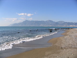
Eboli is a town and comune of Campania, southern Italy, in the province of Salerno.

Monte Grappa is a mountain of the Venetian Prealps in Veneto, Italy. It lies between the Venetian plain to the south and the central alpine areas to the North. To the west, it is parted from the Asiago upland by the Brenta river, and to the east it is separated from the Cesen-Visentin massif by the Piave river. To the north lie Corlo lake and Feltre valley. In the past, the mountain was called Alpe Madre, and is currently divided among three provinces: Vicenza to the west, Treviso to the south and Belluno to the northeast. It is the highest peak of a small massif, which also includes many other peaks such as Col Moschin, Colle della Berretta, Monte Asolone, Monte Pertica, Prassolan, Monti Solaroli, Fontana Secca, Monte Peurna, Monte Santo, Monte Tomatico, Meatte, Monte Pallon, and Monte Tomba.

Monte Generoso is a mountain of the Lugano Prealps, located on the border between Switzerland and Italy and between Lake Lugano and Lake Como. The western and southern flanks of the mountain lie in the Swiss canton of Ticino, whilst the north-eastern flanks are in the Italian region of Lombardy.

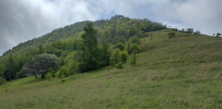
The Monti Picentini is a mountain range and national park in southern Italy, part of the Apennines, traditionally part in the Campanian Apennines. They are included between the Monti Lattari, the Partenio mount, the Irpinian plateau and the Sele river valley. The chain is included in the Monti Picentini Regional Park.
The Monti Lattari are a mountain range in Campania, southern Italy, which constitutes the backbone of the Sorrentine peninsula and of the Amalfi Coast.

The Monte Cetona is a mountain located in the southern Tuscany region of Italy.
Monte Antola is a mountain in Liguria, northern Italy, part of the Ligurian Apennines.

Monte Settepani is 1,386 metres high mountain in Liguria, northern Italy, part of the Ligurian Prealps.
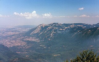
Monte Accellica is a mountain in the Monti Picentini range, located in Campania, Italy. The mountain is 1660 metres tall, and is situated on the border between the provinces of Salerno and Avellino, divided between the comuni of Acerno, Giffoni Valle Piana, and Montella. Several rivers typical of the region have their sources on the slopes of Monte Accellica, including the Picentino, the Tusciano, and the Calore Irpino, which is itself the largest tributary of the Volturno. In the local dialects, the mountain is called Céleca or Acéleca.

The Cinque Vette Park is a natural park, established by the Region of Lombardy on 19 June 2017. The park is located in the north-eastern part of the Province of Varese, in the Italian region of Lombardy. It takes the name from the main geographic features located in the park, the five mountain peaks. The project was launched with the aim of the three local councils of to preserve a green area and make it available for touristic-sportive-cultural initiatives above 500 meters of altitude. The primary goal of the park is to encourage the discovery of the natural features of the north-eastern part of Varese, which offers panoramic view points and preserves historical aspects such as: the remains of the Cadorna Line; the ruins of the Castle of Cuasso al Monte; the Artistic village of Boarezzo; the Saint Gemolo Abbey; the Alpine Village of Mount Piambello; and, the Hospital of Cuasso Al Monte.
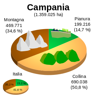
The geography of Campania illustrates the geographical characteristics of Campania, a region of Italy.
The Monte Alpe is a mountain of the Ligurian Prealps, the eastern section of the Ligurian Alps.
