Related Research Articles

Monterey County, officially the County of Monterey, is a county located on the Pacific coast in the U.S. state of California. As of the 2020 census, its population was 439,035. The county's largest city and county seat is Salinas.

Santa Cruz County, officially the County of Santa Cruz, is a county on the Pacific coast of the U.S. state of California. As of the 2020 census, the population was 270,861. The county seat is Santa Cruz. Santa Cruz County comprises the Santa Cruz–Watsonville, CA Metropolitan Statistical Area, which is also included in the San Jose–San Francisco–Oakland, CA Combined Statistical Area. The county is on the California Central Coast, south of the San Francisco Bay Area region. The county forms the northern coast of the Monterey Bay, with Monterey County forming the southern coast.

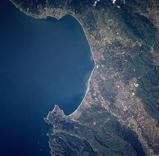
Monterey Bay is a bay of the Pacific Ocean located on the coast of the U.S. state of California, south of the San Francisco Bay Area and its major city at the south of the bay, San Jose. San Francisco itself is further north along the coast, by about 75 miles, accessible via Highway 1 and Highway 280.
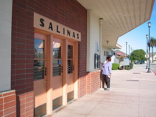
Salinas is a city in California and the county seat of Monterey County. With a population of 163,542 in the 2020 Census, Salinas is the most populous city in Monterey County. Salinas is an urban area located in the Monterey Bay Area, just south of the San Francisco Bay Area and 10 miles (16 km) southeast of the mouth of the Salinas River. The city is located at the mouth of the Salinas Valley, about eight miles (13 km) from the Pacific Ocean, and it has a climate more influenced by the ocean than the interior.

Watsonville is a city in Santa Cruz County, California, located in the Monterey Bay Area of the Central Coast of California. The population was 52,590 according to the 2020 census. Predominantly Latino and Democratic, Watsonville is a self-designated sanctuary city.

The Santa Cruz Mountains, part of the Pacific Coast Ranges, are a mountain range in central and Northern California, United States. They form a ridge down the San Francisco Peninsula, south of San Francisco. They separate the Pacific Ocean from the San Francisco Bay and the Santa Clara Valley, and continue south to the Central Coast, bordering Monterey Bay and ending at the Salinas Valley. The range passes through the counties of San Mateo, Santa Clara, Santa Cruz, San Benito and Monterey, with the Pajaro River forming the southern boundary.

The Central Coast is an area of California, roughly spanning the coastal region between Point Mugu and Monterey Bay. It lies northwest of Los Angeles County and south of San Mateo and Santa Clara counties, and includes the rugged, undeveloped stretch of coastline known as Big Sur. From south to north, there are six counties that make up the Central Coast: Ventura, Santa Barbara, San Luis Obispo, Monterey, San Benito, and Santa Cruz.

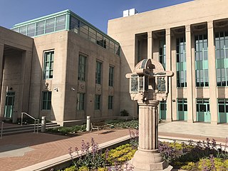
California State University, Monterey Bay is a public university in Monterey County, California. Its main campus is located on the site of the former military base Fort Ord, straddling the cities of Seaside and Marina, about one mile inland from Monterey Bay along the Central Coast of California. CSUMB also has locations in the cities of Monterey and Salinas. Founded in 1994, CSUMB is part of the California State University system and is accredited by the WASC Senior College and University Commission. The university is a Hispanic-serving institution.

The Salinas River is the longest river of the Central Coast region of California, running 175 miles (282 km) and draining 4,160 square miles (10,800 km2). It flows north-northwest and drains the Salinas Valley that slices through the central California Coast Ranges south of Monterey Bay. The river begins in southern San Luis Obispo County, originating in the Los Machos Hills of the Los Padres National Forest. From there, the river flows north into Monterey County, eventually making its way to connect with the Monterey Bay, part of the Pacific Ocean, approximately 5 miles (8.0 km) south of Moss Landing. The river is a wildlife corridor, and provides the principal source of water from its reservoirs and tributaries for the farms and vineyards of the valley.

Central California is generally thought of as the middle third of the state, north of Southern California, which includes Los Angeles, and south of Northern California, which includes San Francisco. It includes the northern portion of the San Joaquin Valley, part of the Central Coast, the central hills of the California Coast Ranges and the foothills and mountain areas of the central Sierra Nevada.

This article describes the present Diocese of Monterey in California. The entity previously known as the Diocese of Monterey from 1849 until 1859, and subsequently known as the Diocese of Monterey-Los Angeles from 1859 until 1922, is the present Archdiocese of Los Angeles. The entity known as the Diocese of Monterey-Fresno from 1922 until 1967 was canonically suppressed with the simultaneous erection of the present Diocese of Monterey in California and the present Diocese of Fresno.

California's 18th congressional district is a congressional district located in the U.S. state of California. The district is currently represented by Democrat Anna Eshoo. It includes portions of Santa Clara, San Mateo, and Santa Cruz counties, extending from the southwestern San Francisco Bay Area through the Santa Cruz Mountains to the Pacific coast.

Area code 831 is a telephone area code in the North American Numbering Plan (NANP) for a small region of the U.S. state of California. The numbering plan area (NPA) comprises Monterey County, San Benito County, and Santa Cruz County. The area code was created on July 11, 1998 in a split from area code 408.

The Pajaro River, is a U.S. river in the Central Coast region of California, forming part of the border between San Benito and Santa Clara Counties, the entire border between San Benito and Santa Cruz County, and the entire border between Santa Cruz and Monterey County. Flowing roughly east to west, the river empties into Monterey Bay, west of Watsonville, California.
The Association of Monterey Bay Area Governments (AMBAG) is a regional governmental organization which consists of representation of a large number of public agencies within Monterey County, Santa Cruz County and San Benito County, California. AMBAG has a broad charter of research and governmental oversight for a variety of functions including elements of land planning, natural resource conservation, energy, transportation, and economic development. The following governmental entities are members of AMBAG:

Simon Salinas is a California politician. He was a member of the California State Assembly district 28 from 2000 to 2006. His district included all of Salinas and Watsonville. Before going to the Assembly, Salinas was a County Supervisor, a City Council Member, a community college instructor, and an elementary school teacher. Salinas is a Democrat. He left the assembly in 2006 because he was termed out. He surprised the political establishment by not challenging Republican incumbent Jeff Denham for the California State Senate district 12. Salinas returned to local politics and was elected to the Monterey County Board of Supervisors in 2006, representing District 3. Salinas has lived most of his life in the Salinas area, growing up around agribusiness. He has one son.

Luis Angel Alejo is an American politician who served in the California State Assembly representing the 30th Assembly District, encompassing the Pajaro and Salinas valleys.
The Central Coast Section (CCS) is the governing body of public and private high school athletics in the portion of California encompassing San Mateo County, Santa Clara County, Monterey County, San Benito County, Santa Cruz County and a few private schools in San Francisco. It is one of ten sections that comprise the California Interscholastic Federation (CIF).
Mission Trail Athletic League (MTAL) was a high school athletic conference part of the CIF Central Coast Section of the California Interscholastic Federation. It comprised high schools generally around Monterey County, California, with schools from southern Santa Clara County, Santa Cruz County and one of only two high schools in San Benito County. Not all schools participated in all sports. In 2017, Mission Trail Athletic League merged with the Monterey Bay League (MBL) to create the Pacific Coast Athletic League (PCAL).
The Monterey County Rail Extension is a planned commuter rail extension that would bring Caltrain passenger service south of its existing Gilroy, California terminus to Salinas in Monterey County, using the existing Coast Line owned by Union Pacific (UPRR). Implementation of the rail extension will occur over three phases, starting from Salinas and moving north. When construction is complete, there will be four trains operated over the extended line per weekday: two northbound trains that depart from Salinas and travel to San Francisco in the morning, and two southbound trains that return to Salinas in the afternoon.
References
- ↑ "Archived copy" (PDF). Archived from the original (PDF) on 2014-10-06. Retrieved 2014-09-27.
{{cite web}}: CS1 maint: archived copy as title (link)