Ecuador is a country in western South America, bordering the Pacific Ocean at the Equator, for which the country is named. Ecuador encompasses a wide range of natural formations and climates, from the desert-like southern coast to the snowcapped peaks of the Andes mountain range to the plains of the Amazon Basin. Cotopaxi in Ecuador is one of the world's highest active volcanos. It also has a large series of rivers that follow the southern border and spill into the northwest area of Peru.

Peru is a country on the central western coast of South America facing the Pacific Ocean. It lies wholly in the Southern Hemisphere, its northernmost extreme reaching to 1.8 minutes of latitude or about 3.3 kilometres (2.1 mi) south of the equator. Peru shares land borders with Ecuador, Colombia, Brazil, Bolivia, and Chile, with its longest land border shared with Brazil.
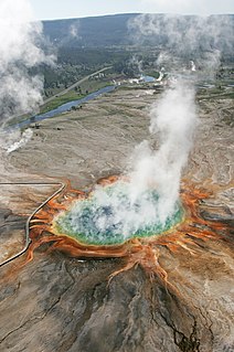
A hot spring is a spring produced by the emergence of geothermally heated groundwater that rises from the Earth's crust. While some of these springs contain water that is a safe temperature for bathing, others are so hot that immersion can result in injury or death.

Banff is a town within Banff National Park in Alberta, Canada. It is located in Alberta's Rockies along the Trans-Canada Highway, approximately 126 km (78 mi) west of Calgary and 58 km (36 mi) east of Lake Louise. At 1,400 to 1,630 m above sea level, Banff is the community with the second highest elevation in Alberta, after Lake Louise.

An oceanic climate, also known as a marine climate or maritime climate, is the Köppen classification of climate typical of west coasts in higher middle latitudes of continents, and generally features mild summers and mild winters, with a relatively narrow annual temperature range and few extremes of temperature, with the exception for transitional areas to continental, subarctic and highland climates. Oceanic climates are defined as having a monthly mean temperature below 22 °C (72 °F) in the warmest month, and above 0 °C (32 °F) in the coldest month.

Osoyoos is the southernmost town in the Okanagan Valley in British Columbia between Penticton and Omak. The town is 3.6 kilometres (2.2 mi) north of the United States border with Washington state and is adjacent to the Osoyoos Indian Reserve. The origin of the name Osoyoos was the word sẁiẁs meaning "narrowing of the waters" in the local Okanagan language (Syilx'tsn). The "O-" prefix is not indigenous in origin and was attached by settler-promoters wanting to harmonize the name with other place names beginning with O in the Okanagan region. There is one local newspaper, the Osoyoos Times.

Monsefú is a town in Northern Peru, capital of the Monsefú district in the Chiclayo Province that is part of the Lambayeque Region. It is renowned for its food and handicrafts, which are on display at the annual FEXTICUM festival, named in 1973 by Professor Limberg Chero Ballena and held in July during Fiestas Patrias. Monsefú is also the home of the cumbia groups Grupo 5 and Hermanos Yaipen. Monsefú was elevated to the category of "city" on October 26, 1888.
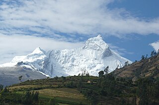
The Cordillera Blanca is a mountain range in Peru that is part of the larger Andes range and extends for 200 kilometres (124 mi) between 8°08' and 9°58'S and 77°00' and 77°52'W, in a northwesterly direction. It includes several peaks over 6,000 metres (19,690 ft) high and 722 individual glaciers. The highest mountain in Peru, Huascarán, at 6,768 metres (22,205 ft) high, is located there.

Esperanza base is a permanent, all year-round Argentine research station in Hope Bay, Trinity Peninsula. It is one of only two civilian settlements in Antarctica. The base's motto is Permanencia, un acto de sacrificio.

Huascarán National Park is a Peruvian national park that comprises most of the mountain range known as Cordillera Blanca which is part of the central Andes, in the region of Ancash. The park covers an area of 340.000 ha and is managed by the Peruvian Network of Protected Natural Areas: SERNANP. It was designated as a World Heritage Site in 1985 by UNESCO, is also a well-known mountaineering spot and harbors a unique biodiversity with plant species such as the Queen of the Andes, trees of the genera Polylepis and Buddleja, and animals such as spectacled bears, condors, vicunas and tarucas.

Mwanza is a port city on the southern shore of Lake Victoria in north-western Tanzania. With a population of more than 800,000, it is Tanzania's second largest city, after Dar es Salaam. Mwanza is the capital of the surrounding Mwanza Region, and is administratively divided into two municipal districts within that Region - Ilemela and Nyamagana.

Puerto Baquerizo Moreno is the capital of Galápagos Province, Ecuador. It is located on the southwestern coast of San Cristóbal, the easternmost island in the archipelago, and is the capital of San Cristóbal Canton. It was founded by General Villamil Playas in the mid-19th century, and takes its name from President Alfredo Baquerizo Moreno (1859–1951). Today, fishing is the main activity of the locals, but tourism is on the increase along the waterfront with numerous hotels and shops.

Lake Conococha is a South American lake located in the Andes mountains of northwestern Peru. It is located in the region of Ancash near the junction of the roads going from Callejón de Huaylas to Chiquián.

Hassi Messaoud is a town in Ouargla Province, eastern Algeria, located 85 kilometres (53 mi) southeast of Ouargla. As of 2008 it had a population of 45,147 people, up from 40,360 in 1998, and an annual population growth rate of 1.1%, the lowest in the province. Oil was discovered there in 1956 and the town's prominence has grown rapidly since then; it is considered as the First Energy town in Algeria where all the big oil and gas companies have offices and bases. It is an oil refinery town named after the first oil well. A water well, dug in 1917, can be found on the airport side of town. Today there are over 800 wells within a 25 kilometres (16 mi) radius of the town.

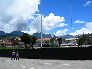
Carhuaz is a town in Peru located in the Ancash Region, Carhuaz Province, Carhuaz District. It is situated at 34 km from Huaraz, at 2,688 msnm. Its temperature average is from 12 to 14 degrees Celsius. Near this city, the hot springs of Monterrey and the airport of Anta are located.

Hồ Tràm is a small beach town located in Vietnam's Bà Rịa–Vũng Tàu Province, in Xuyên Mộc District. It is situated about 125 kilometers southeast of Ho Chi Minh City (HCMC).

The climate of Argentina is a vastly complex subject, as the vast size of the country and wide variation in altitude make for a wide range of climate types. Summers are the warmest and wettest season in most of the country except in most of Patagonia where it is the driest season. Winters are normally mild in the north, cool in the center and cold in the southern parts experiencing frequent frost and snow. Because southern parts of the country are moderated by the surrounding oceans, the cold is less intense and prolonged than areas at similar latitudes in the northern hemisphere. Spring and autumn are transition seasons that generally feature mild weather.

Tofino is a district of approximately 1,932 residents on the west coast of Vancouver Island in the Canadian province of British Columbia. The district is located at the western terminus of Highway 4 on the tip of the Esowista Peninsula at the southern edge of Clayoquot Sound.