
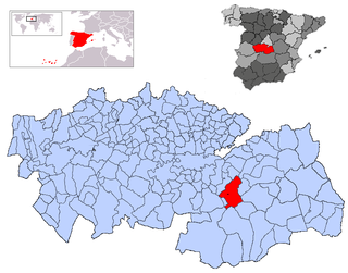
Toledo is a province of central Spain, in the western part of the autonomous community of Castile–La Mancha. It is bordered by the provinces of Madrid, Cuenca, Ciudad Real, Badajoz, Cáceres, and Ávila. Its capital is the city of Toledo.

In Spain, a comarca is either a traditional territorial division without any formal basis, or a group of municipalities, legally defined by an autonomous community for the purpose of providing common local government services. In English, a comarca is equivalent to a district, county, area or zone.

Navas de Estena is a municipality in Ciudad Real, Castile-La Mancha, Spain. It has a population of 404.

Sierra de Cádiz is a comarca province of Cádiz.
El Borge is a town and municipality in the province of Málaga, part of the autonomous community of Andalusia in southern Spain. It is located in the comarca of Axarquía. The municipality is situated approximately 24 kilometers from Vélez-Málaga, 28 from the provincial capital of Málaga and 567 km from Madrid. It has a population of approximately 1,000 residents. The natives are called Borgeños.

Cardiel de los Montes is a municipality located in the province of Toledo, Castile-La Mancha, Spain. According to the 2006 census (INE), the municipality has a population of 256 inhabitants.

Espinoso del Rey is a municipality of Spain located in the province of Toledo, Castilla–La Mancha. The municipality has a total area of 48.28 km2 and, as of 1 January 2019, a registered population of 436, according to the INE.

Mazarambroz is a municipality located in the province of Toledo, Castile-La Mancha, Spain. According to the 2006 census (INE), the municipality has a population of 1314 inhabitants.

Los Navalmorales is a municipality located in the province of Toledo, Castile-La Mancha, Spain. According to the 2006 census (INE), the municipality has a population of 2636 inhabitants.

Los Navalucillos is a municipality located in the province of Toledo, Castile-La Mancha, Spain. According to the 2018 census (INE), the municipality has a population of 2171 inhabitants.

San Martín de Pusa is a municipality located in the province of Toledo, Castile-La Mancha, Spain. According to the 2006 census (INE), the municipality has a population of 825 inhabitants.
San Pablo de los Montes is a municipality located in the province of Toledo, Castile-La Mancha, Spain. According to the 2006 census (INE), the municipality has a population of 2282 inhabitants.
Mora is a town and municipality in Toledo province, in the autonomous community of Castile-La Mancha, Spain. The area is most famous for the abandoned ruins of the San Marcos de Yegros monastery of the Order of Santiago, located northeast of the town of Mora about 10 km on the Calle de los Dolores in the village of Paraje de Yegros.
Mesa de Ocaña is a comarca in Castilla-La Mancha, Spain, in the province of Toledo. Its capital and administrative center is Ocaña. The comarca is located in the northeast part of the province, and encompasses an area that includes several hundred meters of the Tajo River Valley.
La Siberia is a comarca in the northeastern portion of the province of Badajoz in the autonomous community of Extremadura, Spain. Its capital is the municipality of Herrera del Duque. The comarca is bordered to the north by the provinces of Cáceres and Toledo, on the west by Las Vegas Altas comarca, on the south by La Serena comarca, and on the east by the province of Ciudad Real. The district contains 18 municipalities with a combined area of 2,943 km2 (1,136 sq mi) and a population of 29,214 people.

Sierra de la Demanda is a comarca located south-east of the province of Burgos in the autonomous community of Castile and León, Spain. It is bounded on the north-east by the Montes de Oca comarca, north-west by the Alfoz de Burgos, south-east by the province of Soria, south-west by the Ribera del Duero comarca, on the east by the province of La Rioja and west by the Arlanza comarca. It is named after the mountain sub-range of Sierra de la Demanda, the northwesternmost end of the Sistema Ibérico.
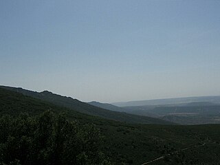
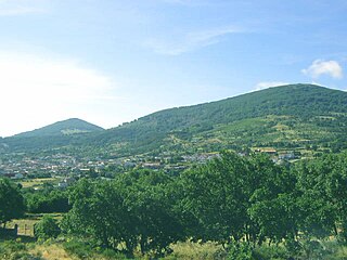
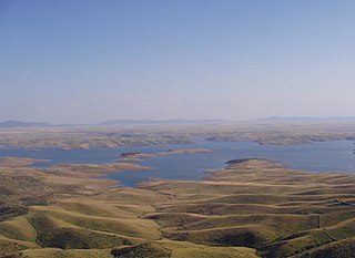
The Montes de Toledo is one of the main systems of mountain ranges in the Iberian Peninsula. They divide the drainage basin of the Tagus from the basin of the Guadiana. The highest peak is La Villuerca, which is 1,603 m (5,259 ft) high.

Las Villuercas is a comarca located in the province of Cáceres, western Spain. It belongs to the Autonomous Community of Extremadura.

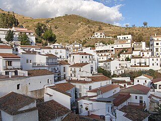
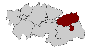
La Jara is a comarca located in the Montes de Toledo at the western end of Toledo Province, it also includes the municipality of Anchuras, an enclave of the province of Ciudad Real, in Castile-La Mancha, Spain. The comarca's capital is Los Navalucillos, however Talavera de la Reina is an important city for local people in La Jara owing to historical ties, even though it is located outside of the comarca.

Sierra de Villuercas or Sierra de las Villuercas, also known as Sierra de Guadalupe after nearby Guadalupe town, is a mountain range in the greater Montes de Toledo range, Spain. It is located in province of Cáceres, autonomous community of Extremadura.
