
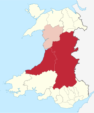
Powys is a county and preserved county in Wales. It borders Gwynedd, Denbighshire, and Wrexham to the north; the English ceremonial counties of Shropshire and Herefordshire to the east; Monmouthshire, Blaenau Gwent, Merthyr Tydfil, Caerphilly, Rhondda Cynon Taf, and Neath Port Talbot to the south; and Carmarthenshire and Ceredigion to the west. The largest settlement is Newtown, and the administrative centre is Llandrindod Wells.

Montgomeryshire is one of thirteen historic counties and a former administrative county of Wales. It is named after its county town, Montgomery, which in turn is named after one of William the Conqueror's main counsellors, Roger de Montgomerie, who was the 1st Earl of Shrewsbury.

Welshpool is a market town and community in Powys, Wales, historically in the county of Montgomeryshire. The town is four miles from the Wales–England border and low-lying on the River Severn; its Welsh language name Y Trallwng means "the marshy or sinking land". The community includes Cloddiau and Pool Quay.

Newtown is a town in Powys, Wales. It lies on the River Severn in the community of Newtown and Llanllwchaiarn, within the historic boundaries of Montgomeryshire. It was designated a new town in 1967 and saw population growth as firms settled, changing its market town character. Its 2001 population of 10,780 rose to 11,357 in the 2011 census, and rose again to 11,362 in the 2021 census.

Llanidloes is a town and community on the A470 and B4518 roads in Powys, within the historic county boundaries of Montgomeryshire, Wales. The population in 2011 was 2,929, of whom 15% could speak Welsh. It is the third largest settlement in Montgomeryshire, after Newtown and Welshpool.

Montgomery is a town and community in Powys, Wales. It is the traditional county town of the historic county of Montgomeryshire to which it gives its name, and it is within the Welsh Marches border area. The town centre lies about 1 mile (1.6 km) west of the England–Wales border. Montgomery Castle was started in 1223 and its parish church in 1227. Other locations in the town include The Old Bell Museum, the Offa's Dyke Path, the Robber's Grave and the town wall. The large Iron Age hill fort of Ffridd Faldwyn is sited northwest of the town and west of the Castle.
Mid Wales or Central Wales is a region of Wales, encompassing its midlands, in-between North Wales and South Wales. The Mid Wales Regional Committee of the Senedd covered the unitary authority areas of Ceredigion and Powys and the area of Gwynedd that had previously been the district of Meirionnydd. A similar definition is used by the BBC. The Wales Spatial Plan defines a region known as "Central Wales" which covers Ceredigion and Powys.

Llanfair Caereinion is a market town and community in Montgomeryshire, Powys, Wales upon the River Banwy, around 8 miles west of Welshpool. In 2011 the ward had a population of 1,810; the town itself had a population of 1,055 according to Nomis.
The Central Wales Football League(formerly the Mid Wales Football League) is a football league in Wales at tier four of the Welsh Football pyramid, run by the Central Wales Football Association. The league consists of two regionally based divisions - a Northern Division and a Southern Division. The league offers a promotion route to the Football Association of Wales administered tier three Ardal Leagues. Relegation is possible to the relevant tier five level leagues in Aberystwyth, Ceredigion and Montgomeryshire.
Abermule is a village lying on the River Severn 6 km northeast of Newtown in Powys, mid Wales. The A483 Swansea to Chester trunk road, the Cambrian Line railway, connecting Aberystwyth to Shrewsbury, and the Montgomery Canal, close to the river, all pass through Abermule. The village had a population of 900 as of the 2011 census.

The District of Montgomeryshire or Montgomery was one of three local government districts of the county of Powys, Wales, from 1974 until 1996. The district had an identical area to the previous administrative county of Montgomeryshire. The district was abolished in 1996, with Powys County Council taking over its functions.

Sarn is a small village in Powys, Wales.

Powys County Council is the local authority for Powys, one of the administrative areas of Wales. The County Hall is in Llandrindod Wells.
The Montgomeryshire Football League is a football league in Mid Wales, sitting at the fifth level of the Welsh football league system.

Forden is a village near Welshpool in Powys, Wales, formerly in the historic county of Montgomeryshire. It forms part of the community of Forden, Leighton and Trelystan with the neighbouring settlements of Trelystan, Leighton and Kingswood.
Poundley and Walker or John Wilkes Poundley and David Walker were a land surveyors and architects’ partnership with offices at Black Hall, Kerry, Montgomeryshire and at Unity Buildings, 22 Lord Street, Liverpool. The partnership was established probably in the mid-1850s and was dissolved in June 1867. The partnership was involved with large country estate building projects, church and civic buildings and some civil engineering. They specialized in building model farms. J. W. Poundley was also the county surveyor for Montgomeryshire from 1861–1872. The architect, canal and railway engineer, T. G. Newnham appears have been associated with the partnership.
Manafon is a small rural community located in the hills of Montgomeryshire, the Northern part of the Welsh county of Powys. The Parish focuses on the valley of the River Rhiew that runs west to east into the River Severn". The community of Manafon consists of "two main villages within about a mile of one another, Manafon and New Mills. The remainder of the population lives in scattered farms and dwellings and in the small rural settlement of The Green."
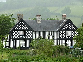
Penarth is a timber-framed house set back from the A483 road near to Newtown, Wales, close to the banks of the river Severn. It is within the parish of Llanllwchaiarn, within the historic county of Montgomeryshire, which now forms part of Powys. It is amongst the best examples of the ‘‘Severn Valley’’ timber-framed houses. The Penarth vineyard stands within the grounds of the house.

Newtown and Llanllwchaiarn is a local government community in mid Powys, Wales. It includes the town of Newtown and the small neighbouring village of Llanllwchaiarn. At the time of the 2011 census the population of the community was 11,357. The community council is called Newtown and Llanllwchaiarn Town Council, often abbreviated to Newtown Town Council.

Montgomery Town Hall is a municipal building in Broad Street, Montgomery, Wales. It served as the meeting place of Montgomery Borough Council and is a Grade II* listed building.

