Montgomery Rocks

Last updated

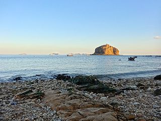
Montgomery Rocks comprises a pair of rocky dolerite and limestone islets, with a combined area of 3.69 ha and a high point of 50 m, part of the Hibbs Pyramid Group, lying close to the central western coast of Tasmania. [1]

Diabase An intrusive mafic rock forming dykes or sills

Diabase or dolerite or microgabbro is a mafic, holocrystalline, subvolcanic rock equivalent to volcanic basalt or plutonic gabbro. Diabase dikes and sills are typically shallow intrusive bodies and often exhibit fine grained to aphanitic chilled margins which may contain tachylite. Diabase is the preferred name in North America, yet dolerite is the preferred name in most of the rest of the world, where sometimes the name diabase is applied to altered dolerites and basalts. Many petrologists prefer the name microgabbro to avoid this confusion.

Limestone Sedimentary rocks made of calcium carbonate

Limestone is a carbonate sedimentary rock that is often composed of the skeletal fragments of marine organisms such as coral, foraminifera, and molluscs. Its major materials are the minerals calcite and aragonite, which are different crystal forms of calcium carbonate (CaCO3). A closely related rock is dolostone, which contains a high percentage of the mineral dolomite, CaMg(CO3)2. In fact, in old USGS publications, dolostone was referred to as magnesian limestone, a term now reserved for magnesium-deficient dolostones or magnesium-rich limestones.

Islet A very small island

An islet is a very small island.

Fauna

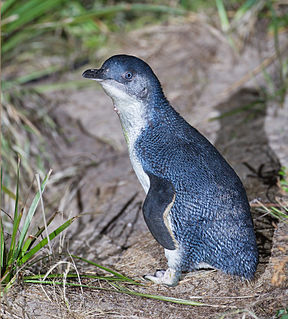
Recorded breeding seabird and wader species are the little penguin (60 pairs), short-tailed shearwater (560 pairs), fairy prion (760 pairs), common diving-petrel (100 pairs), Pacific gull and sooty oystercatcher. The metallic skink is present. [1]

Seabird Birds that have adapted to life within the marine environment

Seabirds are birds that are adapted to life within the marine environment. While seabirds vary greatly in lifestyle, behaviour and physiology, they often exhibit striking convergent evolution, as the same environmental problems and feeding niches have resulted in similar adaptations. The first seabirds evolved in the Cretaceous period, and modern seabird families emerged in the Paleogene.

Wader

Waders are birds commonly found along shorelines and mudflats that wade in order to forage for food in the mud or sand. They are called shorebirds in North America, where the term "wader" is used to refer to long-legged wading birds such as storks and herons. Waders are members of the order Charadriiformes, which includes gulls, auks and their allies.

Little penguin smallest penguin species

The little penguin is the smallest species of penguin. It grows to an average of 33 cm (13 in) in height and 43 cm (17 in) in length, though specific measurements vary by subspecies. It is found on the coastlines of southern Australia and New Zealand, with possible records from Chile. In Australia, they are often called fairy penguins because of their small size. In New Zealand, they are more commonly known as little blue penguins or blue penguins owing to their slate-blue plumage; they are also known by their Māori name: kororā.

Related Research Articles

Dugay Islet is a small island with an area of 0.44 ha in Bass Strait, north-western Tasmania.

Devils Tower comprises two small and rugged granite islands, with a combined area of 4.77 hectares, in south-eastern Australia. It is part of Tasmania’s Curtis Group, lying in northern Bass Strait between the Furneaux Group and Wilsons Promontory in Victoria. It is a nature reserve.

Night Island (Tasmania) island in Tasmania, Australia

Night Island is a small granite island, with an area of 2.59 ha, is part of the Preservation Island Group, lying in eastern Bass Strait south of Cape Barren Island in the Furneaux Group, Tasmania, Australia.

Sentinel Island (Tasmania) island in Tasmania, Australia

Sentinel Island is a granite island, with an area of 10 ha, in south-eastern Australia. It is part of Tasmania’s Sentinel Island Group, lying in eastern Bass Strait off the north-west coast of Flinders Island in the Furneaux Group. Until 1985 it was used for grazing sheep.

Roydon Island is an island, with an area of 37 ha, in south-eastern Australia. It is part of Tasmania’s Pasco Island Group, lying in eastern Bass Strait off the north-west coast of Flinders Island in the Furneaux Group.

The Middle Pasco Islands comprise two similarly sized adjacent granite islands, with a combined area of 8.37 ha, in south-eastern Australia. They form part of Tasmania’s Pasco Island Group, lying in eastern Bass Strait off the north-west coast of Flinders Island in the Furneaux Group.

North Pasco Island island in Tasmania, Australia

North Pasco Island is a granite island, with an area of 28 ha, in south-eastern Australia. It is part of Tasmania’s Pasco Island Group, lying in eastern Bass Strait off the north-west coast of Flinders Island in the Furneaux Group. It was previously used for sheep grazing.

The Nuggets Tasmanian island

The Nuggets is a close group of four granite islets, with a combined area of 6.76 hectares, in south-eastern Australia. It is part of the Schouten Island Group, lying close to the eastern coast of Tasmania near the Freycinet Peninsula.

Picnic Island is a small, privately owned, rocky island, with an area of about one hectare, part of the Schouten Island Group, lying close to the eastern coast of Tasmania near the Freycinet Peninsula. It is composed of sandstone overlying granite.

Ile des Phoques is a rugged granite island, with an area of 8 ha, part of the Schouten Island Group, lying close to the eastern coast of Tasmania, Australia near the Freycinet Peninsula.

Spectacle Island is an island, with an area of 3.5 ha, in south-eastern Australia. It is part of the Sloping Island Group, lying close to the south-eastern coast of Tasmania around the Tasman and Forestier Peninsulas.

Little Spectacle Island is a small island, with an area of 0.62 ha, part of the Sloping Island Group, lying close to the south-eastern coast of Tasmania, Australia around the Tasman and Forestier Peninsulas, and adjacent Spectacle Island.

Barren Island is a small island, with an area of 0.53 ha, in south-eastern Australia. It is part of the Sloping Island Group, lying close to the south-eastern coast of Tasmania around the Tasman and Forestier Peninsulas.

Visscher Island is an island, with an area of 3.4 ha, in south-eastern Tasmania, in Australia.

Leelinger Island is a flat dolerite island with an area of 1.54 ha in south-eastern Australia. It is part of the Hibbs Pyramid Group, lying close to the central western coast of Tasmania.

Hays Reef is a small, rocky islet in south-eastern Australia. It is part of the Hibbs Pyramid Group, lying close to the central western coast of Tasmania.

Entrance Island (Tasmania) island in Tasmania, Australia

Entrance Island is a low island with an area of 6.1 ha. It lies at the entrance to Macquarie Harbour in Western Tasmania at an area known as Hell's Gates. It contains a light beacon and jetty.

Bonnet Island island in Australia

Bonnet Island is a low island with an area of 2.21 ha. It lies at the entrance to Macquarie Harbour in Western Tasmania Australia, in the vicinity of Hells Gates.

Black Island is a jagged and rocky islet in south-eastern Australia. It is part of the Hibbs Pyramid Group, lying close to the central western coast of Tasmania.

Port Davey Islands Important Bird Area

The Port Davey Islands Important Bird Area comprises over 20 small, rocky islands scattered both within, and in the vicinity of, the mouth of Port Davey, an inlet on the south-west coast of Tasmania, Australia. They all lie within the Southwest National Park and are important for breeding seabirds.

References

  1. 1 2 Brothers, Nigel; Pemberton, David; Pryor, Helen; & Halley, Vanessa. (2001). Tasmania’s Offshore Islands: seabirds and other natural features. Tasmanian Museum and Art Gallery: Hobart. ISBN   0-7246-4816-X

Coordinates: 42°46′S145°22′E / 42.767°S 145.367°E / -42.767; 145.367

Geographic coordinate system Coordinate system

A geographic coordinate system is a coordinate system that enables every location on Earth to be specified by a set of numbers, letters or symbols. The coordinates are often chosen such that one of the numbers represents a vertical position and two or three of the numbers represent a horizontal position; alternatively, a geographic position may be expressed in a combined three-dimensional Cartesian vector. A common choice of coordinates is latitude, longitude and elevation. To specify a location on a plane requires a map projection.