
Monu Island is an uninhabited island of the Mamanuca Islands, Fiji. It is located 700 metres west of Yanuya. It is 1,370 metres long from north to south, and up to 1,070 metres wide.
Monu Island is an uninhabited island of the Mamanuca Islands, Fiji. It is located 700 metres west of Yanuya. It is 1,370 metres long from north to south, and up to 1,070 metres wide.
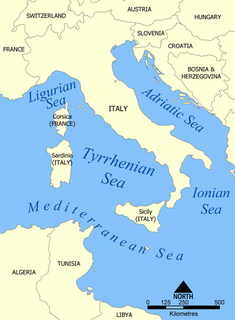
The Tyrrhenian Sea is part of the Mediterranean Sea off the western coast of Italy. It is named for the Tyrrhenian people, identified since the 6th century BCE with the Etruscans of Italy.

Ting Kau Bridge is a 1,177-metre (3,862 ft) long cable-stayed bridge in Hong Kong that spans from the northwest of Tsing Yi Island and Tuen Mun Road. It is near the Tsing Ma Bridge which also serves as a major connector between the Hong Kong International Airport on Lantau Island and the rest of Hong Kong. It was completed on May 5, 1998. The bridge is toll-free.

Western Province is the largest of the nine provinces of Solomon Islands. The area is renowned for its beautiful tropical islands, excellent diving and snorkelling, coral reefs and WWII wrecks, ecotourism lodges, and head-hunting shrines. The province contains many small lagoons and most of the country's tourist trade outside Honiara.
The Yasawa Group is an archipelago of about 20 volcanic islands in the Western Division of Fiji, with an approximate total area of 135 square kilometres (52 sq mi).
Vatulele is a coral and volcanic island 32 kilometres south of Viti Levu, Fiji's largest island. Situated at 18.50° South and 177.63° East, Vatulele has an area of 32 square kilometres. Its maximum altitude is only 320 metres.
This is a list of the extreme points of Cyprus: the points that are farther north, south, east or west than any other location.

The mountains and hills of the British Isles are categorised into various lists based on different combinations of elevation, prominence, and other criteria such as isolation. These lists are used for peak bagging, whereby hillwalkers attempt to reach all the summits on a given list, the oldest being the 282 Munros in Scotland, created in 1891.

Vavrinec is a village and municipality in Vranov nad Topľou District in the Prešov Region of eastern Slovakia.

This is a list of the extreme points of the Philippines, the points that are farther north, south, east or west than any other location in the country. According to Republic Act 9522 of 2009, which defined the archipelagic baselines of the Philippines, identifies the extreme points of the Philippines under Section 1.

Olav V Land is a peninsula in eastern Spitsbergen Island, Svalbard named after Olav V of Norway. It is covered by the Olav V Icefield, measuring about 4,150 square kilometres (1,600 sq mi).

Penguin Bank is the name given to a now-submerged shield volcano of the Hawaiian Islands. Its coral-capped remains lie immediately west of the island of Molokaʻi, under relatively shallow water.
The Wharekopae River is located in the northeast of New Zealand's North Island. A tributary of the Waikohu River, it rises on the slopes of Maungatapere, a 1,050-metre (3,440 ft) peak at the northeastern end of the Huiarau Range, and flows east, reaching the Waikohu River at the settlement of Waikohu, west of Te Karaka.
Dibble Peak is a peak 2.3 nautical miles (4.3 km) southwest of Post Office Hill in the Kyle Hills of Ross Island. The peak rises to about 1,100 metres (3,600 ft) and marks the highest and southwestern-most point of Warren Ridge. At the suggestion of P.R. Kyle, it was named by the Advisory Committee on Antarctic Names (2000) after Raymond R. Dibble, a geophysicist at the Victoria University of Wellington, New Zealand, who visited Cape Crozier in the 1962–63 season; made seismic and volcanic observations of Mount Erebus during the 1970s, also 1980–86 as a founding member of the International Mount Erebus Seismic Study; after retirement from Victoria University and involvement with the New Zealand Antarctic Programme, Dibble joined the United States Antarctic Program (USAP) and the NMIMT team (Kyle) in the maintenance and upgrading of the seismic stations run by the Mount Erebus Volcano Observatory, 1993–94, 1994–95, 1995–96, and 1997–98.
Mount Darnley is a mountain, 1,100 metres (3,600 ft) high, in the south-central portion of Bristol Island in the South Sandwich Islands off Antarctica. It was charted in 1930 by Discovery Investigations personnel on the Discovery II, who named it for E.R. Darnley.
Pōnui Nunatak is a nunatak located 0.6 nautical miles (1.1 km) southeast of Slattery Peak and 5.6 nautical miles (10.4 km) southwest of The Knoll in southeast Ross Island. The feature rises to 320 metres (1,050 ft) near the juncture of the island and the Ross Ice Shelf. The name Pōnui is one of several Māori-language wind names applied by the New Zealand Geographic Board in this vicinity.
Glacier Ridge is a broad north–south ridge, 4.5 nautical miles (8 km) long and 0.8 nautical miles (1.5 km) wide, on the southern slopes of Mount Erebus, Ross Island, Antarctica. Completely ice-covered, the ridge descends from about 2,200 metres (7,200 ft) to 600 metres (2,000 ft), terminating 2.1 nautical miles (3.9 km) northwest of Tyree Head. In association with the names of expedition ships grouped on this island, it was named after the USCGC Glacier, an icebreaker which for three decades, 1955–56 to 1986–87, supported scientific activity in Antarctica and the Ross Sea on virtually an annual basis. From 1955–56, Glacier operated as a US Navy ship. Along with other Navy icebreakers, Glacier was transferred to the US Coast Guard fleet, June 1966, from which she operated until decommissioned, June 1987.

Mancınık Castle is a Hellenistic castle ruin in Mersin Province, Turkey.
Helicia maxwelliana is a plant in the family Proteaceae. It grows as a treelet up to 3 metres (10 ft) tall. The twigs are dark brown. The flowers are reddish brown. The fruit is black, round, up to 2.5 centimetres (1 in) in diameter. Its habitat is montane forest at 1,600 metres (5,200 ft) to 1,700 metres (5,600 ft) altitude. H. maxwelliana is endemic to Borneo.

Saplı Islet is a Mediterranean islet of Turkey. The island is at the Yenikaş coast which is located 4 kilometres (2.5 mi) west of Aydıncık ilçe (district) of Mersin Province. At 36°07′48″N33°17′41″E it forms the west wall of the bay named Soğuksu. Its distance to Mersin is about 177 kilometres (110 mi)
Coordinates: 17°36′S177°03′E / 17.600°S 177.050°E
| This article about a geographical location in Fiji is a stub. You can help Wikipedia by expanding it. |