Moor House-Upper Teesdale

Last updated

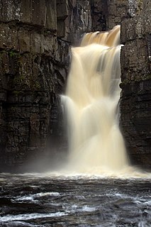
Moor House-Upper Teesdale National Nature Reserve covers 7,400 ha of the Pennine moors in the north of England. It straddles Cumbria and County Durham. It was designated a UNESCO biosphere reserve in 1976.

Hectare metric unit of area

The hectare is an SI accepted metric system unit of area equal to a square with 100-metre sides, or 10,000 m2, and is primarily used in the measurement of land. There are 100 hectares in one square kilometre. An acre is about 0.405 hectare and one hectare contains about 2.47 acres.

Cumbria Ceremonial (geographic) county of England

Cumbria is a ceremonial and non-metropolitan county in North West England. The county and Cumbria County Council, its local government, came into existence in 1974 after the passage of the Local Government Act 1972. Cumbria's county town is Carlisle, in the north of the county, and the only other major urban area is Barrow-in-Furness on the southwestern tip of the county.

County Durham County of England

County Durham is a county in North East England. The county town is Durham, a cathedral city. The largest settlement is Darlington, closely followed by Hartlepool and Stockton-on-Tees. It borders Tyne and Wear to the north east, Northumberland to the north, Cumbria to the west and North Yorkshire to the south. The county's historic boundaries stretch between the rivers Tyne and Tees, thus including places such as Gateshead, Jarrow, South Shields and Sunderland.

Contents

The Moor House area was in the first group of National Nature Reserves (NNRs) created in England when it was designated in 1952. Upper Teesdale was a separate nature reserve until the end of the twentieth century. The combined reserve is England's highest and largest NNR. [1] Great Dun Fell is the highest point. The Pennine Way passes through both “halves” of the reserve.

Upper Teesdale

Upper Teesdale is a Site of Special Scientific Interest (SSSI) in the Teesdale district of west County Durham, England. It encompasses an extensive upland area that includes the headwaters of the River Tees and the surrounding catchment area upstream of the village of Langdon Beck.

Great Dun Fell Mountain in the United Kingdom

At a height of 848 metres, Great Dun Fell is the second-highest mountain in England's Pennines, lying two miles south along the watershed from Cross Fell, its higher neighbour. Together with its smaller twin, Little Dun Fell, which reaches 842 metres, it forms a stepping-stone for the Pennine Way on its long climb up from Dufton.

Pennine Way walking path

The Pennine Way is a National Trail in England, with a small section in Scotland. The trail runs 267 miles (429 km) from Edale, in the northern Derbyshire Peak District, north through the Yorkshire Dales and the Northumberland National Park and ends at Kirk Yetholm, just inside the Scottish border. The path runs along the Pennine hills, sometimes described as the "backbone of England". Although not the United Kingdom's longest National Trail, it is according to the Ramblers' Association "one of Britain's best known and toughest".

See also

Related Research Articles

High Force waterfall

High Force is a waterfall on the River Tees, near Middleton-in-Teesdale, Teesdale, County Durham, England. The waterfall is within the North Pennines Area of Outstanding Natural Beauty (AONB) and European Geopark.

National nature reserves in England designated by Natural England as key places for wildlife and natural features in England

National nature reserves in England are designated by Natural England as key places for wildlife and natural features in England. They were established to protect the most significant areas of habitat and of geological formations. NNRs are managed on behalf of the nation, many by Natural England themselves, but also by non-governmental organisations, including the members of The Wildlife Trusts partnership, the National Trust, and the Royal Society for the Protection of Birds.

National nature reserves in England were established by English Nature, now Natural England, which manages them either directly or through non-governmental organisations such as the Royal Society for the Protection of Birds or the National Trust.

Caerlaverock National Nature Reserve

Caerlaverock is a national nature reserve (NNR) covering parts of the mudflats and shoreline of the Solway Firth about 10 km south of Dumfries, in Dumfries and Galloway, Scotland. It lies between the River Nith and the Lochar Water, and consists of a variety of wetland habitats including bare mud and sand, merse and marshes, and is fringed by neutral grassland on the landward side. A nature reserve was designated in 1957 at the instigation of the Duke of Norfolk. The NNR covers an area of 82 square kilometres (32 sq mi) and is an internationally important wintering site for waterfowl and wading birds.

Startforth Rural District was a rural district in the North Riding of the historic county of Yorkshire in the Pennines of northern England.

North Pennines mountain in the United Kingdom

The North Pennines is the northernmost section of the Pennine range of hills which runs north–south through northern England. It lies between Carlisle to the west and Darlington to the east. It is bounded to the north by the Tyne Valley and to the south by the Stainmore Gap.

Teesdale is a dale, or valley, of the east side of the Pennines in County Durham, England. Large parts of Teesdale fall within the North Pennines Area of Outstanding Natural Beauty (AONB) - the second largest AONB in England and Wales. The River Tees rises below Cross Fell, the highest hill in the Pennines at 2,930 feet (890 m), and its uppermost valley is remote and high. The local climate was scientifically classified as "Sub-Arctic" and snow has sometimes lain on Cross Fell into June.

Mickle Fell mountain in the United Kingdom

Mickle Fell is a mountain in the Pennines, the range of hills and moors running down the middle of Northern England. It is 2,585 feet (788 m) high and lies slightly off the main watershed of the Pennines, about ten miles south of Cross Fell.

Burnhope Seat mountain in the United Kingdom

Burnhope Seat is a moor in the North Pennines of England. It lies between the heads of the Rivers Tees, South Tyne and Wear. The summit is crossed by the boundary between County Durham and Cumbria. It is the highest point in historic County Durham.

Cauldron Snout waterfall

Cauldron Snout is a cascade on the upper reaches of the River Tees in Northern England, immediately below the dam of the Cow Green Reservoir. It is well upstream of the High Force waterfall, and is on the boundary between County Durham and Cumbria, England. The waterfall lies within the North Pennines Area of Outstanding Natural Beauty (AONB) and European Geopark.

Cow Green Reservoir lake in the United Kingdom

Cow Green Reservoir is a 2 miles (3 km) long water reservoir built between 1967 and 1971 to supply the industries of Teesside in England.

Cairnsmore of Fleet mountain in United Kingdom

Cairnsmore of Fleet is a mountain in the Scottish Lowlands, on the edge of the Galloway Forest Park. The mountain forms an unafforested granite massif, whose highest point is about 10 kilometres (6.2 mi) east of Newton Stewart. It is the highest of the "Solway Hills", and the southernmost of Scotland's 219 Grahams. The view to the south takes in the Cree Estuary and Wigtown Bay, and extends as far as the Lake District, the Isle of Man and Snowdonia. The highest summits of the Galloway Hills can be seen to the north, and Ireland is in the view to the west.

Moorhouse and Cross Fell

Moorhouse and Cross Fell is a Site of Special Scientific Interest covering an extensive area of moorland in the Wear Valley district of west County Durham and the Eden district of Cumbria, England. It is contiguous with Upper Teesdale SSSI to the east and Appleby Fells SSSI to the south. The area covered extends roughly from an arc through the villages of Gamblesby, Leadgate and Garrigill southward as far as Milburn in the west and Cow Green Reservoir in the east. It includes the whole of Cross Fell, the summit of which, at 893 metres asl, is the highest point in the Pennines and in England outside the Lake District.

Lune Forest

Lune Forest is a Site of Special Scientific Interest covering an extensive area of moorland in the Teesdale district of west Durham, England. In the north, where it adjoins the Upper Teesdale and Appleby Fells SSSIs, it extends from Mickle Fell eastward almost as far as Harter Fell, above the hamlet of Thringarth. Its southern limit is marked by the River Balder, upstream from Balderhead Reservoir, where it shares a boundary with Cotherstone Moor SSSI to the south. Grains o' th' Beck Meadows and Close House Mine SSSIs are entirely surrounded by Lune Forest, but do not form part of it.

Harter Fell, Lunedale is an area of upland heath in west County Durham, England. It lies on the watershed between the River Tees to the north-east and the River Lune to the south and reaches a maximum height of 481 metres asl about 1 km north of the hamlet of Thringarth.

Geltsdale & Glendue Fells

Geltsdale & Glendue Fells is a Site of Special Scientific Interest in the North Pennines, England. The site has an area of 8059 ha, partly in Cumbria and partly in Northumberland.

References

Coordinates: 54°38′13″N2°18′07″W / 54.637°N 2.302°W / 54.637; -2.302

Geographic coordinate system Coordinate system

A geographic coordinate system is a coordinate system that enables every location on Earth to be specified by a set of numbers, letters or symbols. The coordinates are often chosen such that one of the numbers represents a vertical position and two or three of the numbers represent a horizontal position; alternatively, a geographic position may be expressed in a combined three-dimensional Cartesian vector. A common choice of coordinates is latitude, longitude and elevation. To specify a location on a plane requires a map projection.