
The Eastern Shore is a region of the Canadian province of Nova Scotia. It is the Atlantic coast running northeast from Halifax Harbour to the eastern end of the peninsula at the Strait of Canso.
Mushaboom is a rural community on the Eastern Shore of Nova Scotia, Canada. It is a part of the Halifax Regional Municipality and lies along the Marine Drive on Trunk 7. The community is located about 13 km (8.1 mi) southwest of Sheet Harbour. and east of Taylor Head Provincial Park.

Nova Scotia Trunk 7 is part of the Canadian province of Nova Scotia's system of Trunk Highways. The route runs from Bedford to Antigonish, along the Eastern Shore for a distance of 269 kilometres (167 mi). Part of Trunk 7 is known as the Marine Drive.
The Marine Drive is a designated scenic route along Nova Scotia's Eastern Shore. It closely follows the coast of the Atlantic Ocean and the Strait of Canso from the Canso Causeway to the junction of Route 322 and Highway 111 in Dartmouth.

Ecum Secum is a rural community on the Eastern Shore of Nova Scotia, Canada, located in both the Halifax Regional Municipality and Guysborough County. Located along the shores of Ecum Secum Harbour, an inlet of the Atlantic Ocean, the community is located roughly 46 km (29 mi) east of Sheet Harbour, Nova Scotia, 37 km (23 mi) southwest of Sherbrooke, Nova Scotia, and approximately 160 km (99 mi) east of Downtown Halifax along the Marine Drive on Trunk 7. Several communities along the western shore of the harbour also share the name, including Ecum Secum Bridge and Ecum Secum West. The name of the community is derived from the Mi'kmaq language and means "a red house". The first Europeans to settle in the Ecum Secum area were Loyalists during the 1780s.

Moser River is a rural community on the Eastern Shore of Nova Scotia, Canada, in the Halifax Regional Municipality. The community lies along the Marine Drive on Trunk 7, 32 km (20 mi) east of Sheet Harbour and 51 km (32 mi) southwest of Sherbrooke. The community is located along the shores of Necum Teuch Harbour, an inlet of the Atlantic Ocean, and is at the mouth of Moser River. The area was called Noogoomkeak in the mi'kmaq language, translating to "soft sand place". The community is named for Henry Moser, who was the son of Jacob Moser, who settled the area in the early 1800s. The first school in the community was built in 1905, and another school, Moser River Consolidated School, was built in 1957. The school closed in 2015, due to its very low student population. Marine Drive Academy in Sheet Harbour serves the community and its surroundings at all grade levels. There is a small seaside park in the community near the former school, as well as a post office and convenience store.
Necum Teuch is a small rural community on the eastern shore of the Halifax Regional Municipality Nova Scotia in the Musquodoboit/Sheet Harbour region of the Marine Drive on Trunk 7. The community is famous for the lifelike scarecrows created by Angela Smith Geddes, author of children's books, including "The Scarecrows of Necum Teuch", "Necum Teuch Notes", "The Shadow People", and several others.
Beaver Harbour is a rural community on the Eastern Shore of Nova Scotia, Canada, in the Halifax Regional Municipality. It is located on the Marine Drive, along Trunk 7 approximately 11 km (6.8 mi) east of Sheet Harbour, Nova Scotia. The community is located on the shores of Beaver Harbour, an inlet of the Atlantic Ocean. The mi'kmaq name for the area was Kobelawakwemoode, translating to "beaver harbour". First Nations legends relay that a large rock in the harbour was thrown by Glooscap, a powerful figure in the First Nations' legends, at the mystical beaver. The land on which the community resides was part of a five thousand acre grant given to a surveyor on July 13, 1773. Five families lived here by the 1830s, and a post office was established in the community on October 1, 1887. A Trans-Atlantic cable station is located in the community, for the former CANTAT-2 cable.
East Quoddy is a rural community on the Eastern Shore of Nova Scotia, Canada, in the Halifax Regional Municipality. The community is situated on the Marine Drive along Nova Scotia Trunk 7 about 21 km (13 mi) east of Sheet Harbour, Nova Scotia. It can be found along the eastern shore of Quoddy Harbour, an inlet of the Atlantic Ocean.
East Ship Harbour is a rural community on the Eastern Shore of Nova Scotia, Canada, in the Halifax Regional Municipality. The community is located on the Marine Drive on Nova Scotia Trunk 7, about 33 km (21 mi) west of Sheet Harbour, Nova Scotia. The community is located along the shores of Ship Harbour, an inlet of the Atlantic Ocean. The mi'kmaq name for the area was TedumunaBoogwek, translating to "water-worn rock".

Pleasant Harbour is a rural community located on the Eastern Shore of Nova Scotia, Canada. The community is situated on the Marine Drive, on Nova Scotia Trunk 7, about 30 km (19 mi) west of Sheet Harbour, Nova Scotia. The community is located on the shores of Shoal Bay, an inlet of the Atlantic Ocean. The mi'kmaq name for the area was Wospegeak, translating to "the sunshine is reflected from the water". Settlement of the area began around 1812, and the present name for the community was adopted in 1886.
West Quoddy is a rural community on the Eastern Shore of Nova Scotia, Canada, in the Halifax Regional Municipality. It is located along the Marine Drive on Nova Scotia Trunk 7 about 19 km (12 mi) east of Sheet Harbour, Nova Scotia. The community is located at the mouth of the Quoddy River and the head of Quoddy Harbour. Several small islands are located in the harbour.
Watt Section is a rural community on the Eastern Shore of Nova Scotia, Canada, in the Halifax Regional Municipality. The community is located along Nova Scotia Trunk 7 on the Marine Drive, and is located about 5 km (3.1 mi) southeast of Sheet Harbour, Nova Scotia. The community is located along the eastern side of Sheet Harbour, an inlet of the Atlantic Ocean. The community is named for William Watt, who purchased the land at the present day location of the community in 1844. The cookhouse used at the lumber mill at the head of East River in Sheet Harbour was bought by the residents of Watt Section after the closing of the mill in January 1891, and it was floated down to the community.
Popes Harbour is a rural community of the Halifax Regional Municipality in the Canadian province of Nova Scotia, about 20 km (12 mi) west of Sheet Harbour, Nova Scotia. The community is located along the shores of Popes Harbour, an inlet of the Atlantic Ocean. The mi'kmaq names for the area were Kwemoodech and Kwemoodeech, translating to "little loon place" and "small harbour" respectively. Before 1827, the settlement was referred to as Deane Harbour. The present name for the community is in honour of an early pioneer family. Popes Harbour is known for Abriel's Fisheries.
Marinette is a rural community on the Eastern Shore of Nova Scotia, Canada, in the Halifax Regional Municipality. It is located along Route 224, 11 km (6.8 mi) northwest of Sheet Harbour, along West River. The first land grant here was given to David Redmond from Antrim, Ireland, in 1828.
Murphy Cove is a community on the Eastern Shore of Nova Scotia, Canada, in the Halifax Regional Municipality. The community is located on the Marine Drive on Nova Scotia Trunk 7, about 31 km (19 mi) west of Sheet Harbour, Nova Scotia. The community is named for Thomas Murphy, an Irish settler. The community is situated on the shores of Shoal Bay, an inlet of the Atlantic Ocean. Settlement in the area began in the 1830s.
Spry Harbour is a rural community on the Eastern Shore of Nova Scotia, Canada, in the Halifax Regional Municipality, located along the Marine Drive on Nova Scotia Trunk 7. The community is located about 15 km (9.3 mi) west of Sheet Harbour, Nova Scotia. The community is located around Taylor Bay and Spry Harbour, inlets of the Atlantic Ocean.
Spry Bay is a rural community on the Eastern Shore of Nova Scotia, Canada, in the Halifax Regional Municipality. The community is situated along the Marine Drive on Trunk 7 about 12 km (7.5 mi) southwest of Sheet Harbour, Nova Scotia. The community extends around the shores of Tomlee Bay, an inlet of Spry Bay, itself an inlet of the Atlantic Ocean. The mi'kmaq name for the area was Sebimkouaak, which translates to "extensive bog". Dutch families settled across the bay in 1818, and their settlement was named Dutch Town. The community is the home of the Spry Bay Campground and Cabins, as well as Taylor Head Provincial Park. The park contains sand beaches, 22 km (14 mi) of hiking trails and user facilities.
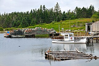
Sober Island is a rural community on the Eastern Shore of Nova Scotia, Canada, in the Halifax Regional Municipality. The community is situated on Sober Island. Sober Island Pond is located in the middle of the island. The community is about 14 km (8.7 mi) south of Sheet Harbour. It is connected to the mainland by Sober Island Road. There are no numbered highways on Sober Island.
Harrigan Cove is a rural community on the Eastern Shore of Nova Scotia, Canada, in the Halifax Regional Municipality. The community is located along the Marine Drive on Nova Scotia Trunk 7 about 25 km (16 mi) east of Sheet Harbour, Nova Scotia. The community is located in the vicinity the cove of the same name and is named for an early settler who came to the area after 1827.
