
Moozhikkal is a small town on Wayanad Road in Kozhikode East, Kerala, India. Moozhikkal is administered by Kozhikode Corporation which is a local city council here. [1]
Moozhikkal is a small town on Wayanad Road in Kozhikode East, Kerala, India. Moozhikkal is administered by Kozhikode Corporation which is a local city council here. [1]
Moozhikkal purayidam sarppakavu is a sacred grove of Moozhikkal. [2] There is another sacred grove for monkeys near Moozhikkal.
Moozhikkal junction has become prominent because it forks to Calicut Medical College and Parambil Bazar areas.
Indian Institute of Spices Research is located near Moozhikkal. This organization is a subsidiary of Indian Council of Agricultural Research, a federal agency of the Government of India. The Institute was established in 1975. The institute provides project based education at masters and doctorate levels. Ph.D. is offered in Biochemistry, Botany, Horticulture, Hematology and Soil Chemistry. The institute has a number of fully equipped labs.
Kozhikode, also known in English as Calicut, is a city along the Malabar Coast in the state of Kerala in India. It has a corporation limit population of 609,224 and a metropolitan population of more than 2 million, making it the second largest metropolitan area in Kerala and the 19th largest in India. Kozhikode is classified as a Tier 2 city by the Government of India.

Thrissur, formerly Trichur, also known by its historical name Thrissivaperur, is a city and the headquarters of the Thrissur district in Kerala, India. It is the third largest urban agglomeration in Kerala after Kochi and Kozhikode, and the 21st largest in India. The city is built around a 65-acre (26 ha) hillock called the Thekkinkaadu Maidaanam which seats a large Hindu Shiva Temple. It is located central of the state, and 304 kilometres (189 mi) north-west of the state's capital city, Thiruvananthapuram. Thrissur was once the capital of the Kingdom of Cochin, and was a point of contact for the Assyrians, Greeks, Persians, Arabs, Romans, Portuguese, Dutch and English.

Kasaragod is a municipal town and administrative headquarters of Kasaragod district in the state of Kerala, India. Established in 1966, Kasaragod was the first municipal town in the district. It is the northernmost district of Kerala and is also known as Saptha Bhasha Sangama Bhoomi.

Wayanad is a district in the north-east of Indian state Kerala with administrative headquarters at the municipality of Kalpetta. It is the only plateau in Kerala. The Wayanad Plateau forms a continuation of the Mysore Plateau, the southern portion of Deccan Plateau. It is set high in the Western Ghats with altitudes ranging from 700 to 2100 meters. Vellari Mala, a 2,240 m (7,349 ft) high peak situated on the trijunction of Wayanad, Malappuram, and Kozhikode districts, is the highest point in Wayanad district. The district was formed on 1 November 1980 as the 12th district in Kerala, by carving out areas from Kozhikode and Kannur districts. An area of 885.92 km2 of the district is forested. Wayanad has three municipal towns—Kalpetta, Mananthavady and Sulthan Bathery. There are many indigenous tribes in this area. The Kabini River, a tributary of Kaveri River, originates at Wayanad. Wayanad district, along with the Chaliyar valley in neighbouring Nilambur in Malappuram district, is known for natural gold fields, which are also seen in other parts of the Nilgiri Biosphere Reserve. Chaliyar river, which is the fourth longest river of Kerala, originates on the Wayanad plateau. The historically important Edakkal Caves are located in Wayanad district.
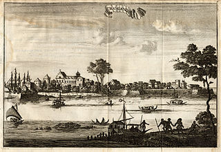
Kodungallur is a historically significant town situated on the banks of river Periyar on the Malabar Coast in Thrissur district of Kerala, India. It is 29 kilometres (18 mi) north of Kochi (Cochin) by National Highway 66 and 38 km (24 mi) from Thrissur. Kodungallur, being a port city at the northern end of the Kerala lagoons, was a strategic entry point for the naval fleets to the extensive Kerala backwaters.
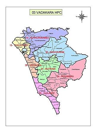
Vatakara, also spelled Vadakara, IPA: [ʋɐɖɐgɐɾɐ], French: Bargaret, is a Municipality in the state of Kerala, India. Vatakara is located between Kannur and Kozhikode. The municipality of Vatakara covers an area of 23.33 km2 (9.01 sq mi) and is bordered by Mahé to the north and Payyoli to the south. It is the headquarters of Vatakara taluk, which consists of 22 panchayats. During the reign of the Kolathiris and Zamorins, Vatakara was known as Kadathanadu. During the British Raj, it was part of the North Malabar region of Malabar District in the state of Madras. The historic Lokanarkavu temple, made famous by the Vadakkan Pattukal, is situated in Vatakara. A new tardigrade species collected from Vadakara coast has been named after Kerala State; Stygarctus keralensis.

Aranmula is a temple town in the state of Kerala, India. It is known as the cultural capital of Pathanamthitta district, located at a distance of around 116 km from Trivandrum, the capital of Kerala, it is situated on the banks of the river Pampa. A centre of pilgrimage from time immemorial and a trade post of eminence, when the river was the chief means of transport, it is near Kozhenchery in Pathanamthitta District. It is easily accessible from Thiruvalla & Chengannur railway stations.It is located around 14 km from Thiruvalla City Centre.

The culture of Kerala has developed over the past millennia, influences from other parts of India and abroad. It is defined by its antiquity and the organic continuity sustained by the Malayali people. Modern Kerala society took shape owing to migrations from different parts of India and abroad throughout Classical Antiquity.

Palakkad, formerly known as Palghat, historically known as Palakkattussery is a city and municipality in the Indian state of Kerala. It is the administrative headquarters of the Palakkad District. Palakkad is most densely populated municipality and fourth densely populated city in Kerala. It was established before Indian independence under British rule and was known by the name Palghat. Palakkad is famous for the ancient Palakkad Fort, which is situated at the heart of the city and was captured and rebuilt by Hyder Ali in 1766. The city is situated about 347 kilometres (216 mi) northeast of the state capital Thiruvananthapuram.

Thirunelli Temple is an ancient temple dedicated to Lord Maha Vishnu on the side of Brahmagiri hill in Kerala, India, near the border with Karnataka state. The temple is at an altitude of about 900m in north Wayanad in a valley surrounded by mountains and beautiful forests. It is 32 km away from Manathavady.
Kerala, a state situated on the tropical Malabar Coast of southwestern India, is one of the most popular tourist destinations in the country. Named as one of the ten paradises of the world by National Geographic Traveler, Kerala is famous especially for its ecotourism initiatives and beautiful backwaters. Its unique culture and traditions, coupled with its varied demography, have made Kerala one of the most popular tourist destinations in the world. Growing at a rate of 13.31%, the tourism industry is a major contributor to the state's economy.

Kerala is a state on the Malabar Coast of India. It was formed on 1 November 1956, following the passage of the States Reorganisation Act, by combining Malayalam-speaking regions of the erstwhile regions of Cochin, Malabar, South Canara, and Thiruvithamkoor. Spread over 38,863 km2 (15,005 sq mi), Kerala is the 21st largest Indian state by area. It is bordered by Karnataka to the north and northeast, Tamil Nadu to the east and south, and the Lakshadweep Sea to the west. With 33 million inhabitants as per the 2011 census, Kerala is the 13th-largest Indian state by population. It is divided into 14 districts with the capital being Thiruvananthapuram. Malayalam is the most widely spoken language and is also the official language of the state.

Kasaragod is one of the 14 districts in the southern Indian state of Kerala. Its northern border Thalappady is located just 10 km south to Ullal, which is the southernmost portion of the major port city Mangalore, on the southwestern Malabar coast of India.

Beaches in the Indian state of Kerala are spread along the 550-km Arabian Sea coastline. Kerala is an Indian state occupying the south-west corner of the subcontinent. The topography of the coastline is distinctive and changes abruptly as one proceeds from north to south. In the northern parts of Kerala, in places such as Bekal, Thalassery and Kannur, the headlands rise above the shore from the fringe of the beaches. The highlands are dotted with forts built by the colonial powers – the Portuguese, the Dutch and the British. The view of the surrounding area is mesmerizing. From Kozhikode, once the hub of the Malabar coast, the view changes to flat lands with rocky outcroppings jutting out. One feature is common all through – the coconut tree in large numbers. Dense groves of coconut trees line the coast and extend to the interiors.
Valayam is a town in Kozhikode district in the state of Kerala, India.

Palode is a town in Thiruvananthapuram district in the Indian state of Kerala. Palode town is 35 km (22 mi) from Thiruvananthapuram city and 17 km (11 mi) from Nedumangad municipality.There is a Helipad in palode. Palode is surrounded by Western Ghats. Jawaharlal Nehru Tropical Botanic Garden and Research Institute is situated near Palode. Mankayam Ecotourism near Brimore is 11 km (6.8

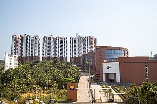
Kunnamangalam is a growing census town located about 14 km east of Kozhikode (Calicut) city on the Calicut - Bangalore National Highway. Nearby places are Koduvally, Mukkam, Chathamangalam, and Kattangal. India's premier educational institutions like Indian Institute of Management, Kozhikode (IIMK), National Institute of Technology Calicut, National Institute of Electronics & Information Technology, Indian Institute of Spices Research, and Kerala School of Mathematics, Kozhikode are located here. Kunnamangalam is developing as a suburb of Kozhikode, Kunnamangalam is the east side entry of Calicut city.

Kozhikode East is a suburb of Kozhikode city in India. Kozhikode East includes areas outside the city jurisdiction but they are still closely associated with the city in terms of commerce and everyday life.

South Malabar refers to a geographical area of the southwestern coast of India covering some parts of the present-day Kerala. South Malabar covers the regions included in present-day Kozhikode taluk of Kozhikode district, the whole area of Malappuram district, Chavakkad taluk of Thrissur district, and Palakkad district, excluding parts of Chittur taluk. The Fort Kochi region of Kochi city also historically belongs to South Malabar. The term South Malabar refers to the region of the erstwhile Malabar District south to the river Korapuzha, and bears a high cultural similarity to both the Cochin and the North Malabar region.