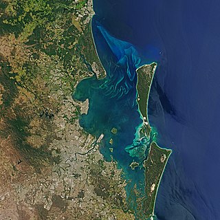
Moreton Bay is a bay located on the eastern coast of Australia 14 kilometres (8.7 mi) from central Brisbane, Queensland. It is one of Queensland's most important coastal resources. The waters of Moreton Bay are a popular destination for recreational anglers and are used by commercial operators who provide seafood to market.

Moreton Island (Mulgumpin) is an island on the eastern side of Moreton Bay on the coast of South East Queensland, Australia. The Coral Sea lies on the east coast of the island. Moreton Island lies 58 kilometres (36 mi) northeast of the Queensland capital, Brisbane. 98% of the island is contained within a national park and a popular destination for day trippers, four wheel driving, camping, recreational angling and whale watching and a 75-minute ferry ride from Brisbane. It is the third largest sand island in the world. Together with Fraser Island, Moreton Island forms the largest sand structure in the world. It was the traditional country of the Ngugi before settlement.

South Stradbroke Island, colloquially South Straddie, is an island that lies within Moreton Bay in the Australian state of Queensland, south of Brisbane and forms the northern end of Gold Coast. The island is a locality within the City of Gold Coast. In the 2021 census, South Stradbroke had a population of 142 people.

Redcliffe is a town and suburb in the City of Moreton Bay, Queensland, Australia. It also refers colloquially to the Redcliffe Peninsula as a whole, a peninsula jutting into Moreton Bay which contains several other suburbs. Since the 1880s, Redcliffe has been a popular seaside resort in South East Queensland. In the 2016 census, the suburb of Redcliffe had a population of 10,373 people.
Redland City, better known as the Redlands and formerly known as Redland Shire, is a local government area and a part of the Brisbane metropolitan area in South East Queensland, Australia. With a population of 159,222 in June 2021, the city is spread along the southern coast of Moreton Bay, covering 537.2 square kilometres (207.4 sq mi). Its mainland borders the City of Brisbane to the west and north-west, and Logan City to the south-west and south, while its islands are situated north of the City of Gold Coast.

The Shire of Pine Rivers was a local government area about 20 kilometres (12 mi) north of Brisbane in the Moreton Bay region of South East Queensland, Australia. The shire covered an area of 771 square kilometres (297.7 sq mi), and existed as a local government entity from 1888 until 2008, when it amalgamated with councils further north and east to form the Moreton Bay Region, renamed in July 2023 as the City of Moreton Bay.

Cleveland is a coastal and central locality in the City of Redland, Queensland, Australia. In the 2016 census, Cleveland had a population of 14,801 people.

Wynnum is a coastal suburb in the City of Brisbane, Queensland, Australia. In the 2016 census, Wynnum had a population of 12,915 people. The suburb is a popular destination in Brisbane due to its coastline, jetty and tidal wading pool.
Samford is a town in the City of Moreton Bay, South East Queensland, Australia. It consists of two localities, Samford Village and Samford Valley.

Deception Bay is a coastal suburb in the City of Moreton Bay, Queensland, Australia. In the 2016 census, Deception Bay had a population of 19,850 people.

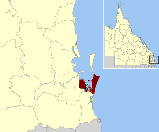
The City of Moreton Bay, known until July 2023 as the Moreton Bay Region, is a local government area in the north of the Brisbane metropolitan city in South East Queensland, Australia. Established in 2008, it replaced three established local government areas, the City of Redcliffe and the Shires of Pine Rivers and Caboolture.

The Somerset Region is a local government area located in the West Moreton region of South East Queensland, Australia, about 100 kilometres (62 mi) northwest of Brisbane and centred on the town of Esk. It was created in 2008 from a merger of the Shire of Esk and the Shire of Kilcoy. It is commonly known as the Brisbane Valley, due to the Brisbane River which courses through the region, although significant parts of the region lie outside the hydrological Brisbane Valley itself.
Australian heritage laws exist at the national (Commonwealth) level, and at each of Australian Capital Territory, New South Wales, Northern Territory, Queensland, South Australia, Tasmania, Victoria, Western Australia state and territory levels. Generally there are separate laws governing Aboriginal cultural heritage and sacred sites, and historical heritage. State laws also allow heritage to be protected through local government regulations, such as planning schemes, as well.
The Queensland Heritage Council is an independent statutory authority created by the Queensland Parliament under the Queensland Heritage Act 1992. The Council advises and reports to the Minister for Environment and the Great Barrier Reef and is supported by a secretariat provided by the Department of Environment and Science. It is also responsible for maintaining the Queensland Heritage Register.
The Queensland Heritage Register is a heritage register, a statutory list of places in Queensland, Australia that are protected by Queensland legislation, the Queensland Heritage Act 1992. It is maintained by the Queensland Heritage Council. As at 5 April 2020 there are 1790 places on the Queensland Heritage Register, including the Story Bridge in Brisbane and the Ross River Meatworks Chimney in Townsville.

The City of Brisbane is a local government area (LGA) which comprises the inner portion of the metropolitan area of Brisbane, the capital of Queensland, Australia. Its governing body is the Brisbane City Council.
The Brisbane Heritage Register is a heritage register containing a list of culturally-significant places within the City of Brisbane, Queensland, Australia. Under Section 113 of the Queensland Heritage Act 1992, all local government authorities in Queensland must maintain a local heritage register.
The Gold Coast Local Heritage Register is a heritage register containing a list of culturally-significant places within the City of Gold Coast, Queensland, Australia. Under Section 113 of the Queensland Heritage Act 1992, all local government authorities in Queensland must maintain a local heritage register.

The Southern Downs Local Heritage Register is a heritage register of sites within the Southern Downs Region of Queensland, Australia.
The Scenic Rim Local Heritage Register is a heritage register containing a list of culturally-significant places within the Scenic Rim Region, Queensland, Australia. Under Section 113 of the Queensland Heritage Act 1992, all local government authorities in Queensland must maintain a local heritage register.