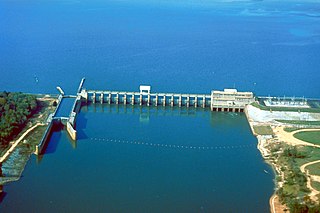
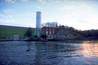
Morgan Falls Dam is a small hydroelectricdam located along the Chattahoochee River at the northern end of Sandy Springs, Georgia, and crossing the river westwards into eastern Cobb County in north metro Atlanta. Originally constructed in 1904 by Georgia Power to provide electricity for Atlanta's streetcars, it now provides enough power for about 4,400 homes; upon completion the dam created Bull Sluice Lake. It was named for then recently deceased Georgia Power president S. Morgan Smith's mother whose maiden name was Morgan. At the time it was by far the largest hydroelectric plant in the state.[1] In 1924 it was rebuilt as a 60 cycle plant with 15,000 kilowatts (up from the original 10,500kW).[2] In 1957 it was raised to regulate the flow from the larger Buford Dam, 36 miles (58km) upstream, in order to give Atlanta water during the hours it was needed most.[3] It is 896 feet (273m) long, and 56 feet (17m) tall. The dam's license from the Federal Energy Regulatory Commission (FERC) was issued in May 2008, and expires in February 2039 which authorizes a capacity of 16,800kW.[4]
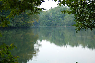
The construction of the dam changed the river upstream from a narrow river with rapids into a wetland. The wetland serves as a habitat for migrating birds, waterfowl, songbirds, beavers, muskrats, and numerous species of reptiles and amphibians.[5]
Notes
↑ Wright, Wade, The History of the Georgia Power Company, GPC, 1957, p.109
↑ Wright, Wade, The History of the Georgia Power Company, GPC, 1957, p.183
↑ Martin, Herald, Atlanta and Environs, Vol III, UGA Press, 1987, p.260
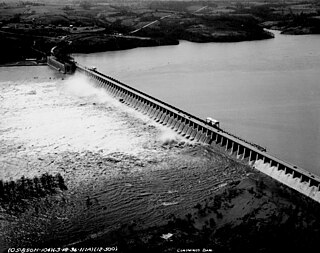
Saint Anthony Falls, or the Falls of Saint Anthony, located at the northeastern edge of downtown Minneapolis, Minnesota, is the only natural major waterfall on the Mississippi River. Throughout the mid-to-late 1800s, various dams were built atop the east and west faces of the falls to support the milling industry that spurred the growth of the city of Minneapolis. In 1880, the central face of the falls was reinforced with a sloping timber apron to stop the upstream erosion of the falls. In the 1950s, the apron was rebuilt with concrete, which makes up the most visible portion of the falls today. A series of locks were constructed in the 1950s and 1960s to extend navigation to points upstream.
The Chattahoochee River is a river in the Southeastern United States. It forms the southern half of the Alabama and Georgia border, as well as a portion of the Florida and Georgia border. It is a tributary of the Apalachicola River, a relatively short river formed by the confluence of the Chattahoochee and Flint rivers and emptying from Florida into Apalachicola Bay in the Gulf of Mexico. The Chattahoochee River is about 430 miles (690 km) long. The Chattahoochee, Flint, and Apalachicola rivers together make up the Apalachicola–Chattahoochee–Flint River Basin. The Chattahoochee makes up the largest part of the ACF's drainage basin.
The Tallulah River is a 47.7-mile-long (76.8 km) river in Georgia and North Carolina. It begins in Clay County, North Carolina, near Standing Indian Mountain in the Southern Nantahala Wilderness and flows south into Georgia, crossing the state line into Towns County. The river travels through Rabun County and ends in Habersham County. It cuts through the Tallulah Dome rock formation to form the Tallulah Gorge and its several waterfalls. The Tallulah River intersects with the Chattooga River to form the Tugaloo River at Lake Tugalo in Habersham County. It joins South Carolina's Seneca River at Lake Hartwell to form the Savannah River, which flows southeastward into the Atlantic Ocean.
The Toccoa River and Ocoee River are the names in use for a single 93-mile-long (150 km) river that flows northwestward through the southern Appalachian Mountains of the southeastern United States. It is a tributary of the Hiwassee River, which it joins in Polk County, Tennessee, near the town of Benton. Three power generating dams are operated along it.
The Flint River is a 344-mile-long (554 km) river in the U.S. state of Georgia. The river drains 8,460 square miles (21,900 km2) of western Georgia, flowing south from the upper Piedmont region south of Atlanta to the wetlands of the Gulf Coastal Plain in the southwestern corner of the state. Along with the Apalachicola and the Chattahoochee rivers, it forms part of the ACF basin. In its upper course through the red hills of the Piedmont, it is considered especially scenic, flowing unimpeded for over 200 miles (320 km). Historically, it was also called the Thronateeska River.
Bull Sluice Lake is a small reservoir located along the Chattahoochee River in northern Georgia, in the northern suburbs of metro Atlanta. It is 673 acres (272 ha), and is impounded by the Morgan Falls Dam. Besides the hydroelectric power produced by the dam, the lake's primary use is recreation, including fishing and rowing.
Kelly Barnes Dam was an earthen embankment dam on Toccoa Creek in Stephens County, Georgia, United States, just outside the city of Toccoa. Heavy rainfall caused it to collapse on November 6, 1977, and the resulting flood killed 39 people and caused $2.8 million in damage. The dam was never rebuilt.
Sope Creek is an 11.6-mile-long (18.7 km) stream located in Cobb County, Georgia, United States. It is a significant tributary of the Chattahoochee River. It was known as Soap Creek during the 19th century. A section of Sope Creek runs through the Chattahoochee River National Recreation Area.
The Conowingo Dam is a large hydroelectric dam in the lower Susquehanna River near the town of Conowingo, Maryland. The medium-height, masonry gravity dam is one of the largest non-federal hydroelectric dams in the U.S., and the largest dam in the state of Maryland.
Ford Dam, officially known as Lock and Dam No. 1, is on the Upper Mississippi River and is located between Minneapolis and Saint Paul, Minnesota just north of the confluence of the Mississippi with the Minnesota River at Mississippi River mile 847.9, in Minneapolis. The powerhouse portion was previously owned by the Ford Motor Company, which operated a hydroelectric power station to feed electricity to its Twin Cities Assembly Plant on the east side of the river. It was sold to Brookfield Power Co. in April 2008. The dual-lock facility and dam was built and is operated by the St. Paul district of the U.S. Army Corps of Engineers' Mississippi Valley Division.
Lake Rabun is a twisty 835-acre (3.4 km2) reservoir with 25 miles (40 km) of shoreline located in the Northeastern corner of the U.S. state of Georgia in Rabun County. It is the third lake in a six-lake series that follows the original course of the Tallulah River. The series begins with Lake Burton as the northernmost lake, followed by Lake Seed, Lake Rabun, Lake Tallulah Falls, Lake Tugalo, and Lake Yonah. Lake Rabun was built in a deep valley located along a 10-mile (16 km) section of the Tallulah River.
The Roswell Railroad was a 3 ft narrow gauge railroad that ran from south of Roswell, Georgia to Chamblee from 1881 until 1921, after which the tracks were removed. The railroad served as a passenger and freight carrier.
Georgia Power is an electric utility headquartered in Atlanta, Georgia, United States. It was established as the Georgia Railway and Power Company and began operations in 1902 running streetcars in Atlanta as a successor to the Atlanta Consolidated Street Railway Company.
Lake Seminole is a reservoir located in the southwest corner of Georgia along its border with Florida, maintained by the U.S. Army Corps of Engineers. The Chattahoochee and Flint rivers join in the lake, before flowing from the Jim Woodruff Lock and Dam, which impounds the lake, as the Apalachicola River. The lake contains 37,500 acres (152 km2) of water, and has a shoreline of 376 mi (605 km). The fish in Lake Seminole include largemouth bass, crappie, chain pickerel, catfish, striped bass and other species. American alligators, snakes and various waterfowl are also present in the lake, which is known for its goose hunting.
Lake Tugalo is a 597-acre (2.42 km2) reservoir with 18 miles (29 km) of shoreline located in the northeastern Georgia in Habersham and Rabun counties, but also lies partially in Oconee County, South Carolina. It is the fifth lake in a six-lake series created by hydroelectric dams operated by Georgia Power that follows the original course of the Tallulah River. The series starts upstream on the Tallulah River with Lake Burton followed by Lake Seed, Lake Rabun, Lake Tallulah Falls and Lake Tugalo, ending with Lake Yonah. The western arm of Lake Tugalo is filled by the Tallulah River and the eastern arm is filled by the Chattooga River. Georgia Power considers the lake full at a surface elevation of 891.5 feet (271.7 m).
North Highlands Dam is a structure on the Chattahoochee River at the northern edge of the Columbus, Georgia, United States. It is approximately 4.2 miles (6.8 km) north of 9th Avenue in downtown Columbus. The dam was built in 1899 to provide power for the former Bibb City Mill. It was one of the first large dams constructed in the South. The North Highlands Dam was owned by the Columbus Electric and Power Company, until that utility was purchased by Georgia Power in 1930.
Tallulah Falls Lake is a 63-acre (250,000 m2) reservoir with 3.6 miles (5.8 km) of shoreline located in the Northeastern corner of Georgia in Rabun County. It is the fourth and smallest lake in a six-lake series created by hydroelectric dams operated by Georgia Power that follows the original course of the Tallulah River. The series starts upstream on the Tallulah River with Lake Burton followed by Lake Seed, Lake Rabun, Tallulah Falls Lake, Lake Tugalo and Lake Yonah. Georgia Power considers the lake full at a surface elevation of 1,500 feet (460 m).
Blue Ridge Dam is a hydroelectric dam on the Toccoa River in Fannin County, in the U.S. state of Georgia. It is the uppermost of four dams on the Toccoa/Ocoee River owned and operated by the Tennessee Valley Authority. The dam impounds the 3,300-acre (1,300 ha) Blue Ridge Lake on the southwestern fringe of the Blue Ridge Mountains.
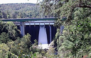
Moore Dam is a major hydroelectric dam on the Upper Connecticut River between Grafton County, New Hampshire and Caledonia County, Vermont in the northeastern United States. The dam is located near Littleton, New Hampshire, and forms the 3,490-acre (1,410 ha) Moore Reservoir. The Moore Station is the largest conventional hydroelectric plant in New England, in terms of installed capacity and average power generation. The dam and reservoir also provide flood control, recreational boating and fishing.
This page is based on this Wikipedia article Text is available under the CC BY-SA 4.0 license; additional terms may apply. Images, videos and audio are available under their respective licenses.