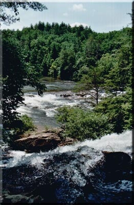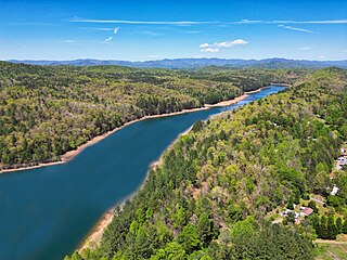
The Chattahoochee River is a river in the Southeastern United States. It forms the southern half of the Alabama and Georgia border, as well as a portion of the Florida and Georgia border. It is a tributary of the Apalachicola River, a relatively short river formed by the confluence of the Chattahoochee and Flint rivers and emptying from Florida into Apalachicola Bay in the Gulf of Mexico. The Chattahoochee River is about 430 miles (690 km) long. The Chattahoochee, Flint, and Apalachicola rivers together make up the Apalachicola–Chattahoochee–Flint River Basin. The Chattahoochee makes up the largest part of the ACF's drainage basin.

The Little Tennessee River is a 135-mile (217 km) tributary of the Tennessee River that flows through the Blue Ridge Mountains from Georgia, into North Carolina, and then into Tennessee, in the southeastern United States. It drains portions of three national forests— Chattahoochee, Nantahala, and Cherokee— and provides the southwestern boundary of the Great Smoky Mountains National Park.

The Apalachicola River is a river, approximately 160 miles (260 km) long, in the state of Florida. The river's large watershed, known as the Apalachicola, Chattahoochee and Flint (ACF) River Basin, drains an area of approximately 19,500 square miles (50,500 km2) into the Gulf of Mexico. The distance to its farthest head waters in northeast Georgia is approximately 500 miles (800 km). Its name comes from Apalachicola Province, an association of Native American towns located on what is now the Chattahoochee River. The Spanish included what is now called the Chattahoochee River as part of one river, calling all of it from its origins in the southern Appalachian foothills down to the Gulf of Mexico the Apalachicola.

Morgan Falls Dam is a small hydroelectric dam located along the Chattahoochee River at the northern end of Sandy Springs, Georgia, and crossing the river westwards into eastern Cobb County in north metro Atlanta. Originally constructed in 1904 by Georgia Power to provide electricity for Atlanta's streetcars, it now provides enough power for about 4,400 homes; upon completion the dam created Bull Sluice Lake. It was named for then recently deceased Georgia Power president S. Morgan Smith's mother whose maiden name was Morgan. At the time it was by far the largest hydroelectric plant in the state. In 1924 it was rebuilt as a 60 cycle plant with 15,000 kilowatts. In 1957 it was raised to regulate the flow from the larger Buford Dam, 36 miles (58 km) upstream, in order to give Atlanta water during the hours it was needed most. It is 896 feet (273 m) long, and 56 feet (17 m) tall. The dam's license from the Federal Energy Regulatory Commission (FERC) was issued in May 2008, and expires in February 2039 which authorizes a capacity of 16,800 kW.

The Chattooga River is the main tributary of the Tugaloo River.

The Nottely River is a river in the United States. The river originates in the Blue Ridge Mountains in northern Georgia. The river flows for 51.1 miles (82.2 km) into the artificial Hiwassee Reservoir in North Carolina. The Nottely River is dammed in Georgia, creating Lake Nottely. Arkaqua Creek is a tributary.
The Roswell Railroad was a 3 ft narrow gauge railroad that ran from south of Roswell, Georgia to Chamblee from 1881 until 1921, after which the tracks were removed. The railroad served as a passenger and freight carrier.
Goat Rock Lake is a 940-acre (3.8 km2) reservoir on the Chattahoochee River, which lies directly south of Bartlett's Ferry Dam and north of Lake Oliver. The lake is created by the Goat Rock Dam and Generating Plant. The name of the dam and lake date to the construction of the dam in 1912. Reportedly, construction workers saw goats jumping onto rocks in the river.

Lake Harding, also known as Bartlett's Ferry Lake, is a 5,850-acre (23.7 km2) reservoir on the Chattahoochee River. The lake is formed by Bartlett's Ferry Dam, and the border between Georgia and Alabama traverses the main channel along the western side of the lake. The Georgia side lies entirely within Harris County while the Alabama shoreline's entirety is in Lee County. Lake Harding is a deep lake with a depth of over 100 feet (30 m) at the dam itself.
The Dog River is a 15.7-mile-long (25.3 km) river in Georgia. The river rises south of Villa Rica in Carroll County, flows east into Douglas County, then turns southeastward into Dog River Reservoir. The reservoir, completed in 1992, impounded 1.2 billion US gallons (4,500,000 m3) of water before the dam and water level were increased in 2009. The reservoir serves as a water source for Douglas County. After leaving the reservoir, the Dog River flows into the Chattahoochee River.
The New River is a 24.5-mile-long (39.4 km) tributary of the Chattahoochee River in Coweta and Heard counties in the U.S. state of Georgia. Rising 4 miles (6 km) south of the city of Newnan, the New River flows generally southwest, reaching the Chattahoochee at West Point Lake approximately 8 miles (13 km) west of Hogansville.

Spring Creek is a 76.5-mile-long (123.1 km) tributary of the Flint River in southwest Georgia in the United States.
Tobesofkee Creek is a 58.9-mile-long (94.8 km) river in Georgia. It originates near Barnesville and flows roughly southeast across Lamar, Monroe, and Bibb counties to join the Ocmulgee River south of the city of Macon. A dam on this stream forms Lake Tobesofkee.
Upatoi Creek is a 35.5-mile-long (57.1 km) river in western Georgia, just outside Columbus. It runs from Upatoi, through South Columbus, and to the Chattahoochee River.

Willeo Creek is a 6.7-mile-long (10.8 km) stream in the U.S. state of Georgia, and is located in the north-northwestern part of metro Atlanta. It is a significant tributary of the Chattahoochee River, into which it flows at Bull Sluice Lake, just upstream from Morgan Falls Dam and downstream from the Chattahoochee Nature Center. Together, the two streams form nearly all of the county line between Fulton to the east and Cobb to the west.
Sturgeon River is a 63.6-mile-long (102.4 km) river in the U.S. state of Michigan, flowing mostly southward through Alger County and Delta County counties on the Upper Peninsula.

Lake Marvin is a reservoir in Floyd County, in the U.S. state of Georgia. The lake was named for Marvin Muze, the original landowner.

Smith Creek is a stream in White County of the American state of Georgia, and is a tributary of the Chattahoochee River. The creek is approximately 6.65 miles (10.70 km) long.
Wahoo Creek-Little River is a watershed in northeastern Georgia, encompassing three separate streams and four sub-watersheds, all of which come together and flow into Lake Lanier north of Gainesville. All three streams, namely Wahoo Creek, West Fork Little River, and East Fork Little River, rise in the very southwestern corner of White County, west of U.S. Route 129, and flow through Lumpkin County and Hall County into Lake Lanier. The watershed is part of the Upper Chattahoochee sub-basin of the larger Apalachicola basin.

Buford Dam is a dam in Buford, Georgia which is located at the southern end of Lake Lanier, a reservoir formed by the construction of the dam in 1956. The dam itself is managed by the United States Army Corps of Engineers.


