
Early County is a county located on the southwest border of the U.S. state of Georgia. As of the 2020 census, the population was 10,854. The county seat is Blakely, where the Early County Courthouse is located. Created on December 15, 1818, it was named for Peter Early, 28th Governor of Georgia. The county is bordered on the west by the Chattahoochee River, forming the border with Alabama.
Columbus is a consolidated city-county located on the west-central border of the U.S. state of Georgia. Columbus lies on the Chattahoochee River directly across from Phenix City, Alabama. It is the county seat of Muscogee County, with which it officially merged in 1970. Columbus is the second most populous city in Georgia, and fields the state's fourth-largest metropolitan area. At the 2020 census, Columbus had a population of 206,922, with 328,883 in the Columbus metropolitan area. The metro area joins the nearby Alabama cities of Auburn and Opelika to form the Columbus–Auburn–Opelika Combined Statistical Area, which had an estimated population of 486,645 in 2019.

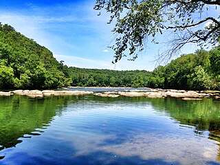
The Chattahoochee River forms the southern half of the Alabama and Georgia border, as well as a portion of the Florida and Georgia border. It is a tributary of the Apalachicola River, a relatively short river formed by the confluence of the Chattahoochee and Flint rivers and emptying from Florida into Apalachicola Bay in the Gulf of Mexico. The Chattahoochee River is about 430 miles (690 km) long. The Chattahoochee, Flint, and Apalachicola rivers together make up the Apalachicola–Chattahoochee–Flint River Basin. The Chattahoochee makes up the largest part of the ACF's drainage basin.

Six Flags Over Georgia is a 290-acre (1.2 km2) theme park located in Austell. Opened in 1967, it is the second park in the Six Flags chain following the original Six Flags Over Texas, which opened in 1961.

Lake Lanier is a reservoir in the northern portion of the U.S. state of Georgia. It was created by the completion of Buford Dam on the Chattahoochee River in 1956, and is also fed by the waters of the Chestatee River. The lake encompasses 38,000 acres (150 km2) or 59 sq mi (150 km2) of water, and 692 mi (1,114 km) of shoreline at normal level, a "full pool" of 1,071 ft (326 m) above mean sea level and the exact shoreline varies by resolution according to the coastline paradox. Named for poet Sidney Lanier, it was built and is operated by the U.S. Army Corps of Engineers for flood control and water supplies. Its construction destroyed more than 50,000 acres (20,000 ha) of farmland and displaced more than 250 families, 15 businesses, and relocated 20 cemeteries along with their remains in the process.

The Walter F. George Lake, named for Walter F. George (1878–1957), a United States senator from Georgia, is formed on the Chattahoochee River along the state line between Alabama and Georgia. It is also widely known by the name, Lake Eufaula – particularly in Alabama, where the state legislature passed a resolution on June 25, 1963, to give the lake that name. The 46,000 acres (190 km2) lake extends north about 85 miles (140 km) from the Walter F. George Lock and Dam and has approximately 640 miles (1,030 km) of shoreline. Popular activities along the lake include camping and trophy fishing.
The Chattahoochee Valley Railway was a shortline railroad linking a number of textile mills between West Point, Georgia and McGinty, Alabama for a total distance of 9.5 miles (15.3 km). As a subsidiary of West Point Pepperell, the entire railroad was abandoned in 1992.
Hitchiti was a tribal town in what is now the Southeast United States. It was first known as part of the Apalachicola Province, an association of tribal towns along the Chattahoochee River. Shortly after 1690, the towns of Apalachicola Province moved to the central part of present-day Georgia, with Hitchiti joining most of those towns along Ochese Creek. In 1715, most of the towns on Ochese Creek, including Hitchiti, moved back to the Chattahoochee River, where the town remained until its people were forced to move to the Indian Territory as part of the Trail of Tears. Hitchiti was one of several towns whose people spoke the Hitchiti language.
Chattahoochee River National Recreation Area (CRNRA) preserves a series of sites between Atlanta and Lake Sidney Lanier along the Chattahoochee River in Georgia, U.S. The 48-mile (77 km) stretch of the river affords public recreation opportunities and access to historic sites. The national recreation area, a National Park Service unit, was established on August 15, 1978, by President Jimmy Carter.
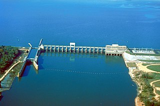
Lake Seminole is a reservoir located in the southwest corner of Georgia along its border with Florida, maintained by the U.S. Army Corps of Engineers. The Chattahoochee and Flint rivers join in the lake, before flowing from the Jim Woodruff Lock and Dam, which impounds the lake, as the Apalachicola River. The lake contains 37,500 acres (152 km2) of water, and has a shoreline of 376 mi (605 km). The fish in Lake Seminole include largemouth bass, crappie, chain pickerel, catfish, striped bass and other species. American alligators, snakes and various waterfowl are also present in the lake, which is known for its goose hunting.
Lake Harding, also known as Bartlett's Ferry Lake, is a 5,850-acre (23.7 km2) reservoir on the Chattahoochee River.
Lake Oliver is a 2,150-acre (8.7 km2) reservoir on the Chattahoochee River, which lies south of Goat Rock Dam. The lake is created by the Oliver Dam and Generating Plant, which was completed in 1959 by Georgia Power.
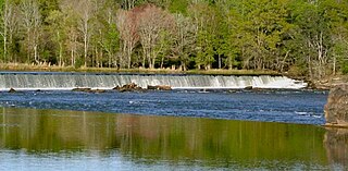
Langdale Dam is a lowhead dam on the Chattahoochee River just south of Langdale, Alabama.
Riverview Dam is a lowhead dam on the Chattahoochee River. The dam was built in 1918 to provide power for Riverview Textile Mill. The dam is currently owned by Georgia Power.

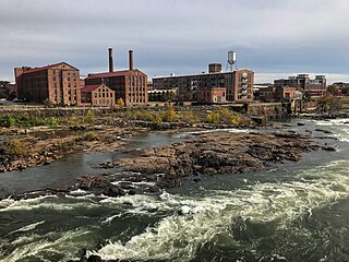
City Mills Dam was a dam on the Chattahoochee River, between Downtown Columbus, Georgia, and Phenix City, Alabama. The dam was built in 1907 to power the City Mills grist mill. Previously, a wooden dam dating to 1828 had existed at the site. The dam impounded a 1.3-mile (2.1 km) run of the river reservoir of approximately 110 acres (0.45 km2).

The Eagle and Phenix Dam was a stone dam on the Chattahoochee River, in downtown Columbus, Georgia. The dam was built in 1882 to power the Eagle and Phenix Textile Mill. It was located just south of the 13th Street Bridge connecting Columbus to Phenix City, Alabama. The dam produced a 45-acre (18 ha) run of the river reservoir that extended approximately 1 mile (1.6 km) upstream.
Riverview Historic District is a historic district along the Chattahoochee River in River View, Alabama. It was listed on the Alabama Register of Landmarks and Heritage on December 19, 1991, and on the National Register of Historic Places on November 12, 1999.
The tri-state water dispute is a 21st-century water-use conflict among the U.S. states of Georgia, Alabama, and Florida over flows in the Apalachicola-Chattahoochee-Flint River Basin and the Alabama-Coosa-Tallapoosa River Basin. The U.S. Army Corps of Engineers has regulated water flow for the entire Chattahoochee River, from Lake Lanier in Forsyth County, Georgia, to Alabama and Florida.

West Point Lake is a man-made reservoir located mostly in west-central Georgia on the Chattahoochee River and maintained by the U.S. Army Corps of Engineers (USACE). The Chattahoochee river flows in from the north, before flowing through the West Point Dam, which impounds the lake, and continuing to Columbus, Georgia. Of the four major USACE lakes in the ACF River Basin, West Point Lake is the smallest by area containing 25,864 acres (10,467 ha) of water, and has the second shortest shoreline at 604 mi (972 km). The purposes of the reservoir are to provide flood control, hydroelectric power, and water storage to aid the navigation of the lower Chattahoochee.

Buford Dam is a dam in Buford, Georgia which is located at the southern end of Lake Lanier, a reservoir formed by the construction of the dam in 1956. The dam itself is managed by the United States Army Corps of Engineers.
