
Fort Gaines is a city in Georgia, United States, with a population of 1,107 at the 2010 census. The city is the county seat of Clay County.

West Point is a city in Troup and Harris counties in the U.S. state of Georgia. It is located approximately halfway between Montgomery, Alabama and Atlanta along Interstate 85. As of the 2010 census, it had a population of 3,474, and in 2015 the estimated population was 3,728. Most of the city is in Troup County, which is part of the LaGrange Micropolitan Statistical Area, and hence part of the Atlanta-Athens-Clarke County-Sandy Springs, GA Combined Statistical Area. A sliver in the south is in Harris County, which is part of the Columbus Metropolitan Statistical Area.

The Chattahoochee River forms the southern half of the Alabama and Georgia border, as well as a portion of the Florida - Georgia border. It is a tributary of the Apalachicola River, a relatively short river formed by the confluence of the Chattahoochee and Flint rivers and emptying from Florida into Apalachicola Bay in the Gulf of Mexico. The Chattahoochee River is about 430 miles (690 km) long. The Chattahoochee, Flint, and Apalachicola rivers together make up the Apalachicola–Chattahoochee–Flint River Basin. The Chattahoochee makes up the largest part of the ACF's drainage basin.

Lake Lanier is a reservoir in the northern portion of the U.S. state of Georgia. It was created by the completion of Buford Dam on the Chattahoochee River in 1956, and is also fed by the waters of the Chestatee River. The lake encompasses 38,000 acres (150 km2) or 59 sq mi (150 km2) of water, and 692 mi (1,114 km) of shoreline at normal level, a "full pool" of 1,071 ft (326 m) above mean sea level and the exact shoreline varies by resolution according to the coastline paradox. Named for poet Sidney Lanier, it was built and is operated by the U.S. Army Corps of Engineers for flood control and water supplies. Its construction destroyed more than 50,000 acres (20,000 ha) of farmland and displaced more than 250 families, 15 businesses, and relocated 20 cemeteries along with their corpses in the process.

The Walter F. George Lake, named for Walter F. George (1878–1957), a United States senator from Georgia, is formed on the Chattahoochee River along the state line between Alabama and Georgia. It is also widely known by the name, Lake Eufaula – particularly in Alabama, where the state legislature passed a resolution on June 25, 1963, to give the lake that name. The 46,000-acre lake extends north about 85 miles (140 km) from the Walter F. George Lock and Dam and has approximately 640 miles (1,030 km) of shoreline. Popular activities along the lake include camping and trophy fishing.
The Chattahoochee Valley Railway was a shortline railroad linking a number of textile mills between West Point, Georgia and McGinty, Alabama for a total distance of 9.5 miles (15.3 km). As a subsidiary of West Point Pepperell, the entire railroad was abandoned in 1992.

The oval pigtoe is a federally endangered species of freshwater mussel, an aquatic bivalve mollusk in the family Unionidae, the river mussels.
Goat Rock Lake is a 940-acre (3.8 km2) reservoir on the Chattahoochee River, which lies directly south of Bartlett's Ferry Dam and north of Lake Oliver. The lake is created by the Goat Rock Dam and Generating Plant. The name of the dam and lake date to the construction of the dam in 1912. Reportedly, construction workers saw goats jumping onto rocks in the river.
Lake Harding, also known as Bartlett's Ferry Lake, is a 5,850-acre (23.7 km2) reservoir on the Chattahoochee River.
Lake Oliver is a 2,150-acre (8.7 km2) reservoir on the Chattahoochee River, which lies south of Goat Rock Dam. The lake is created by the Oliver Dam and Generating Plant, which was completed in 1959 by Georgia Power.
Crow Hop Dam is a lowhead dam on the Chattahoochee River. The dam was built to channel the river westward around the west side of Hills Island to increase generation capacity at Riverview Dam slightly downstream. It is very close to, but does not touch, the Alabama state line, which here lies along the river's western bank, in Chambers County, Alabama, west of Hills Island.
Riverview Dam is a lowhead dam on the Chattahoochee River. The dam was built in 1918 to provide power for Riverview Textile Mill. The dam is currently owned by Georgia Power.

City Mills Dam was a dam on the Chattahoochee River, between Downtown Columbus, Georgia, and Phenix City, Alabama. The dam was built in 1907 to power the City Mills grist mill. Previously, a wooden dam dating to 1828 had existed at the site. The dam impounded a 1.3-mile (2.1 km) run of the river reservoir of approximately 110 acres (0.45 km2).

The Eagle and Phenix Dam was a stone dam on the Chattahoochee River, in downtown Columbus, Georgia. The dam was built in 1882 to power the Eagle and Phenix Textile Mill. It was located just south of the 13th Street Bridge connecting Columbus to Phenix City, Alabama. The dam produced a 45-acre (18 ha) run of the river reservoir that extended approximately 1 mile (1.6 km) upstream.
Riverview Historic District is a historic district along the Chattahoochee River in River View, Alabama. It was listed on the Alabama Register of Landmarks and Heritage on December 19, 1991, and on the National Register of Historic Places on November 12, 1999.
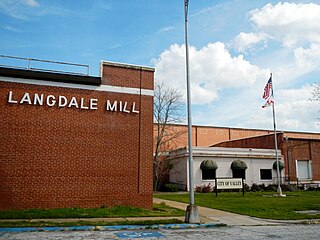
Langdale Historic District is a historic district in Valley, Alabama and Harris County, Georgia, United States. It was listed on the Alabama Register of Landmarks and Heritage on July 22, 1991, and the National Register of Historic Places (NRHP) on November 12, 1999. It lies primarily in Valley, Alabama, on the West side of the Chattahoochee River.
The tri-state water dispute is a 21st-century water-use conflict among the U.S. states of Georgia, Alabama, and Florida over flows in the Apalachicola-Chattahoochee-Flint River Basin and the Alabama-Coosa-Tallapoosa River Basin. The U.S. Army Corps of Engineers has regulated water flow for the entire Chattahoochee River, from Lake Lanier in Forsyth County, Georgia, to Alabama and Florida.
The Halloween darter is a small freshwater fish native to North America. It is found in Georgia and Alabama in the drainage basin of the Apalachicola River, specifically in the Flint River system and the Chattahoochee River system. It prefers shallow, fast-flowing areas with gravel bottoms in small and medium-sized rivers. It was first described in 2008, having not previously been distinguished from the blackbanded darter (P. nigrofasciata), which occurs in the same watershed. The color is somewhat variable, being generally blackish dorsally, with some individuals having indistinct saddle-like barring. Males have orange and dark lateral striping while females have dark stripes and a yellowish-green belly. At a maximum standard length of 101 mm (4 in), males are slightly larger than females, and both sexes develop distinctive orange barring on the edge of the first dorsal fin during the breeding season.

West Point Lake is a man-made reservoir located mostly in west-central Georgia on the Chattahoochee River and maintained by the U.S. Army Corps of Engineers (USACE). The Chattahoochee river flows in from the north, before flowing through the West Point Dam, which impounds the lake, and continuing to Columbus, Georgia. Of the four major USACE lakes in the ACF River Basin, West Point Lake is the smallest by area containing 25,864 acres (10,467 ha) of water, and has the second shortest shoreline at 604 mi (972 km). The purposes of the reservoir are to provide flood control, hydroelectric power, and water storage to aid the navigation of the lower Chattahoochee.

The Chattahoochee Valley Railroad Trail, sometimes referred to as the CVRR Trail, is a 7.5-mile long asphalt-covered rail trail in Valley, Alabama. Made from a section of the defunct Chattahoochee Valley Railway, the trail runs through all four historic districts of the town. These districts were formerly separate towns that were serviced by the railroad. These towns later combined to form the town of Valley in 1980.

