
Dalmatia is one of the four historical regions of Croatia, alongside Croatia proper, Slavonia, and Istria.

Kotor is a coastal town in Montenegro. It is located in a secluded part of the Gulf of Kotor. The city has a population of 13,510 and is the administrative center of Kotor Municipality.
Šibenik is a historic city in Croatia, located in central Dalmatia where the river Krka flows into the Adriatic Sea. Šibenik is a political, educational, transport, industrial and tourist center of Šibenik-Knin County, and is also the third-largest city in the historic region of Dalmatia. As of 2011, the City of Šibenik has 46,332 inhabitants, while the town has 34,302 inhabitants.

Salona was an ancient city and the capital of the Roman province of Dalmatia. The name Salona preserves the language of the early inhabitants of this area whom the Romans called the Dalmatae, considered to be part of a larger group called the Illyrians. Salona is situated in today's town of Solin, right next to Split, in modern-day Croatia.

Ston is a settlement and a municipality in the Dubrovnik-Neretva County of Croatia, located at the south of isthmus of the Pelješac peninsula.

Makarska is a city on the Adriatic coastline of Croatia, about 60 km (37 mi) southeast of Split and 140 km (87 mi) northwest of Dubrovnik, in the Split-Dalmatia County. It is rapidly growing in population, but even more in tourist housing.

Silba is an island in Croatia with an area of 15 km2, northern Dalmatia, south-east of Lošinj, between the islands of Premuda and Olib. It has a Mediterranean climate with 2570 hours a year of sunshine. Most summer days are hot, bright and clear with light westerly Maestral wind cooling the island in the afternoons.
Liburnia in ancient geography was the land of the Liburnians, a region along the northeastern Adriatic coast in Europe, in modern Croatia, whose borders shifted according to the extent of the Liburnian dominance at a given time between 11th and 1st century BC. Domination of the Liburnian thalassocracy in the Adriatic Sea was confirmed by several Antique writers, but the archeologists have defined a region of their material culture more precisely in northern Dalmatia, Kvarner and eastern Istria.

Bosnia is the northern region of Bosnia and Herzegovina, encompassing roughly 81% of the country; the other region, the southern part, is Herzegovina.
Orišje is one of 43 villages in the municipality of Bosiljevo, Croatia. It has a population of 50.
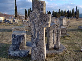
Stećak or Stećci in plural form is the name for monumental medieval tombstones, that lie scattered across Bosnia and Herzegovina, and the border parts of Croatia, Montenegro and Serbia. An estimated 60,000 are found within the borders of modern Bosnia and Herzegovina and the rest of 10,000 are found in what are today Croatia (4,400), Montenegro (3,500), and Serbia (2,100), at more than 3,300 odd sites with over 90% in poor condition.

The Church of the Holy Salvation or Holy Saviour was a Pre-Romanesque church in the Dalmatian Hinterland, Croatia, whose ruins are now a historic site. It is located in the small village of Cetina, near the spring of the river Cetina, 8 km northwest from the town of Vrlika.
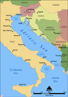
The Adriatic Sea is a body of water separating the Italian Peninsula from the Balkans. The Adriatic is the northernmost arm of the Mediterranean Sea, extending from the Strait of Otranto to the northwest and the Po Valley. The countries with coasts on the Adriatic are Albania, Bosnia and Herzegovina, Croatia, Italy, Montenegro and Slovenia.
The Tariotes or Tariotae were an Illyrian tribe that lived on the Adriatic coast of Dalmatia, in modern-day Croatia. They are considered part of the Dalmatae. The Tariotes are mentioned in the Classical literature by Roman author Pliny the Elder alone. In Pliny's Natural History the territory of the Tariotes is called Tariota and is mentioned as an ancient region, while their city is called Tariona, and described as a castellum, i.e. a stronghold. Tariona was located between the Krka River in the north and Cape Ploča in the south, along the coastal area. Tariote territory is also testified by two boundary inscriptions dating back to Roman Imperial times, which were found in the area of Marina. Those inscriptions refer to the boundaries of pastures used by the tribe of the Tariotes. A passage in the Libri Coloniarum of the Gromatici Veteres, probably dating back to the 5th century AD, is also considered to report the name of the tribe, along with that of the Sardeates.
Jadrtovac is a village in Croatia.
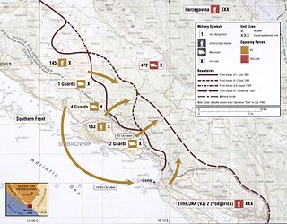
Operation Tiger was a Croatian Army (HV) offensive conducted in areas of Croatia and Bosnia and Herzegovina near Dubrovnik between 1 and 13 July 1992. It was designed to push the Army of Republika Srpska (VRS) away from the city towards Popovo field and secure a supply route via Rijeka Dubrovačka, which was gained in early June as the Siege of Dubrovnik by the Yugoslav People's Army (JNA) was lifted. The operation's success was facilitated by the establishment of the HV's Southern Front command and the successful conclusion of the May–June 1992 operations against the VRS in the Neretva River valley, which concluded with Operation Jackal.
Kula Atlagića is a settlement in the Benkovac municipality, in the Zadar County in Croatia. It is located in the Ravni Kotari region of Dalmatia. The settlement is inhabited by ethnic Serbs.

St. Michael's Fortress in the Croatian town of Šibenik is a medieval fort situated on a steep hill above the old historic center of the city. Its strategically favorable and dominant position made it the central part of Šibenik fortification system. The location was more or less continuously occupied since the Iron Age, as is witnessed by numerous archaeological findings from the era. The city of Šibenik was first mentioned on Christmas Day of 1066 in a charter signed by King Petar Krešimir IV and verified by his courtiers. It is widely considered that the signing took place at St. Michael's Fortress.

The Lapčan family was one of the twelve noble tribes of the Kingdom of Croatia, mentioned in the Pacta conventa. Their seat was in the town of Lapac in the former Luka županija, Dalmatia. Their noble rights were confirmed in the second half of the 13th century until when were jobbágy. In the 14th century branched Karinjani, with seat in Karin, whose name would eventually become more dominant than of Lapčan. The family's coat of arms is described in the 15th century and united with the one by Kurjaković family in the mid-17th century, it became used by the Austrian-Bavarian Sinzendorf noble family.
The Poletčić family, also known as Polečić or Poličić, was one of the twelve noble tribes of the Kingdom of Croatia, mentioned in the Pacta conventa. They until the 15th century had estates in the region of Lika, around Perušić, and citizen status in the city of Zadar.
