Noshiro is a city located in Akita Prefecture, Japan. As of 28 February 2023, the city had an estimated population of 49,150 in 24,079 households, and a population density of 120 persons per km2. The total area of the city is 426.95 square kilometres (164.85 sq mi).

Wyangala Dam is a major gated rock fill with clay core embankment and gravity dam with eight radial gates and a concrete chute spillway across the Lachlan River, located in the south-western slopes region of New South Wales, Australia. The dam's purpose includes flood mitigation, hydro-power, irrigation, water supply and conservation. The impounded reservoir is called Lake Wyangala.

Kitaakita is a city located in Akita Prefecture, Japan. As of 28 February 2023, the city had an estimated population of 29,201, and a population density of 120 persons per km2. and a population density of 25 persons per km2. The total area of the city is 1,152.76 square kilometres (445.08 sq mi).

Pine Flat Dam is a concrete gravity dam on the Kings River in the Central Valley of Fresno County, California United States. Situated about 28 miles (45 km) east of Fresno, the dam is 440 feet (130 m) high and impounds Pine Flat Lake, in the foothills of the Sierra Nevada just outside the boundary of Kings Canyon National Park. The dam's primary purpose is flood control, with irrigation, hydroelectric power generation and recreation secondary in importance.
The Nam Ngum Dam is a hydroelectric dam on the Nam Ngum River, a major tributary of the Mekong River in Laos. It was the first hydropower dam built in the Lao PDR.

The Klamath Project is a water-management project developed by the United States Bureau of Reclamation to supply farmers with irrigation water and farmland in the Klamath Basin. The project also supplies water to the Tule Lake National Wildlife Refuge, and the Lower Klamath National Wildlife Refuge. The project was one of the first to be developed by the Reclamation Service, which later became the Bureau of Reclamation.

Gavins Point Dam is a 1.9-mile-long (3 km) embankment rolled-earth and chalk-fill dam which spans the Missouri River and impounds Lewis and Clark Lake. The dam joins Cedar County, Nebraska with Yankton County, South Dakota a distance of 811.1 river miles (1,305 km) upstream of St. Louis, Missouri, where the river joins the Mississippi River. The dam and hydroelectric power plant were constructed as the Gavins Point Project from 1952 to 1957 by the United States Army Corps of Engineers as part of the Pick-Sloan Plan. The dam is located approximately 4 miles (6.4 km) west or upstream of Yankton, South Dakota.

The flooding of the Nile has been an important natural cycle in Nubia and Egypt since ancient times. It is celebrated by Egyptians as an annual holiday for two weeks starting August 15, known as Wafaa El-Nil. It is also celebrated in the Coptic Church by ceremonially throwing a martyr's relic into the river, hence the name, The Martyr's Finger. The flooding of the Nile was poetically described in myth as Isis's tears of sorrow for Osiris when killed by his brother Set.

Split Rock Dam is a minor ungated concrete faced rock fill embankment dam with concrete chute spillway across the Manilla River upstream of Manilla in the north-western slopes region of New South Wales, Australia. The dam's purpose includes flood mitigation, irrigation, water supply and conservation. The impounded reservoir is called Split Rock Reservoir.
The Central Utah Project is a United States federal water project that was authorized for construction under the Colorado River Storage Project Act of April 11, 1956, as a participating project. In general, the Central Utah Project develops a portion of Utah's share of the yield of the Colorado River, as set out in the Colorado River Compact of 1922.

Magat Dam is a large rock-fill dam in the island of Luzon in the Philippines. The dam is located along the Magat River, a major tributary of the Cagayan River. The construction of the dam started in 1975 and was completed in 1982. It is one of the largest dams in the Philippines. It is a multi-purpose dam which is used primarily for irrigating about 85,000 hectares of agricultural lands, flood control, and power generation through the Magat Hydroelectric Power Plant.

Cougar Dam is a 519-foot (158 m) tall rockfill hydroelectric dam in the U.S. state of Oregon. It has a gated concrete spillway and a powerhouse with two turbines totaling 25 megawatts of electric power.

Aburagi Dam (油木ダム) is a dam built upstream on the class-B Imagawa River, located in the town of Soeda, in the Tagawa District of Fukuoka Prefecture, Japan.
Asahi Dam (朝日ダム) is a dam built on the class 1 Hida River, located in the city of Takayama, Gifu Prefecture, Japan.

Agigawa Dam is a dam built on the Kiso River system, located in the Higashino section of Ena City, in Gifu Prefecture, Japan.

Fontenelle Dam was built between 1961 and 1964 on the Green River in southwestern Wyoming. The 139-foot (42 m) high zoned earthfill dam impounds the 345,360-acre-foot (0.42600 km3) Fontenelle Reservoir. The dam and reservoir are the central features of the Seedskadee Project of the U.S. Bureau of Reclamation, which manages the Fontenelle impoundment primarily as a storage reservoir for the Colorado River Storage Project. The dam suffered a significant failure in 1965, when the dam's right abutment developed a leak. Emergency releases from the dam flooded downstream properties, but repairs to the dam were successful. However, in 1983 the dam was rated "poor" under Safety Evaluation of Existing Dams (SEED) criteria, due to continuing seepage, leading to an emergency drawdown. A concrete diaphragm wall was built through the core of the dam to stop leakage.

Hanayama Dam is a dam on the Hasama River, belonging to the Kitakami Class A river system, in Kurihara, Miyagi Prefecture, Japan, completed in 1957.

Naruko Dam is a concrete gravity-arch dam on the Eaigawa River, a tributary of the Kitakami River system, located in the city of Ōsaki, Miyagi Prefecture, Japan. Completed in 1958 by Kajima Corporation, it is managed by the Tohoku Regional Development Bureau of the Ministry of Land, Infrastructure, Transport and Tourism.

Chiya Dam is a dam constructed near the origin of the class A Takahasi river, located in Niimi, Okayama Prefecture, Japan.

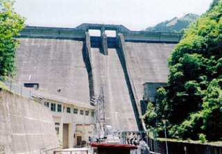
Sagae Dam is a rockfill dam located in Yamagata Prefecture in Japan. The dam is used for flood control, water supply and power production. The catchment area of the dam is 231 km2. The dam impounds about 340 ha of land when full and can store 109000 thousand cubic meters of water. The construction of the dam was started on 1972 and completed in 1990.