
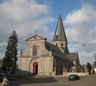
Hemelveerdegem is a village and borough which makes up part of the municipality of Lierde in the Denderstreek in the Belgian province of East Flanders. The village and estate were ruled from 1752 by the armigerous Boelare family.
Machelen, or in full Machelen-aan-de-Leie, is a village in the municipality of Zulte in the province of East Flanders of Belgium. It was the hometown of the painter Roger Raveel.

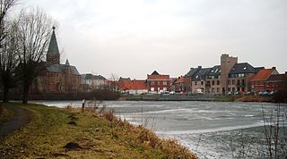
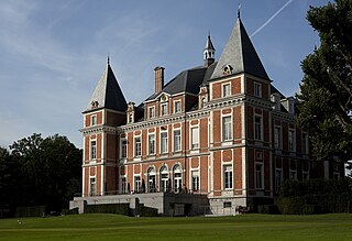
Bazel is a village in Belgium, in the municipality of Kruibeke in the province of East Flanders. The village is home to the Wissekerke Castle. The municipality of Bazel merged into Kruibeke in 1977.

Melsele is a town in the Belgian province of East Flanders, between the city of Beveren and the nearby town of Zwijndrecht. Tram route 3 which starts just outside the town connects it to Zwijndrecht and Antwerp. The town's road links include the E17 and the E34.
Sint-Maria-Oudenhove is a village in the Denderstreek and in the Flemish Ardennes, the hilly southern part of the province of East Flanders, Belgium.

Geistingen is a historic village that is now a submunicipality of Kinrooi, in the Limburg province in the Flemish Community of Belgium.

Beerlegem is a village belonging to the municipality of Zwalm. It is located in the Flemish Ardennes, the hilly southern part of the province of East Flanders, Belgium. Until 1970, it was an independent municipality.
Godveerdegem is a village belonging to the municipality of Zottegem. It is located on the Molenbeek-Ter Erpenbeek in the Denderstreek and in the Flemish Ardennes, the hilly southern part of the province of East Flanders, Belgium.
Leeuwergem is a village belonging to the municipality of Zottegem. It is located on the Molenbeek, in the Denderstreek and Flemish Ardennes, which is part of the hilly southern part of the East Flanders province, Belgium.
Kerselare is a hamlet and pilgrimage site in Edelare, a village belonging to the municipality of Oudenaarde in the province of East Flanders, Belgium. Kerselare is located on the Edelareberg, the highest point of Edelare

Erwetegem is a village and deelgemeente (sub-municipality) belonging to the municipality of Zottegem. It is located in the Denderstreek and in the Flemish Ardennes, the hilly southern part of the province of East Flanders, Belgium. Erwetegem used to an independent municipality until 1970.
Vinderhoute is a village in the municipality of Lievegem in the province of East Flanders in Belgium. It is located in the Flemish Valley about 6 kilometres (3.7 mi) north-west of Ghent.

Zevergem is a village and deelgemeente (sub-municipality) of De Pinte in East Flanders, Belgium. It is located on the Scheldt about 8 kilometres (5.0 mi) south of Ghent.

Verrebroek is a village and deelgemeente in the municipality of Beveren in East Flanders, Belgium. Verrebroek was an independent municipality until 1 January 1977, when it merged with Beveren as part of the fusion of municipalities in Belgium.

Haasdonk is a village and deelgemeente (sub-municipality) of Beveren in East Flanders, Belgium. Haasdonk was an independent municipality until 1 January 1977, when it merged with Beveren as part of the fusion of municipalities in Belgium. It is located about 12 kilometres (7.5 mi) west of Antwerp.

Sleidinge is a village in the municipalities of Evergem in the province of East Flanders, Belgium. It is located about 10 kilometres (6.2 mi) north-west of Ghent.

Rutten is a village in the Tongeren municipality of the Limburg province in the Flemish Community of Belgium. The village is located in the Haspengouw region, and was a separate municipality until its merger into Tongeren in 1977.
Meerle is a village in the Belgian municipality of Hoogstraten in the province of Antwerp. As of 2021, it has about 3,871 inhabitants.
Huise is a village on a hill within the municipality of Zingem, part of the province of East Flanders in Belgium.
Petegem-aan-de-Schelde is a village and former municipality in the Wortegem-Petegem municipality in the Belgian province of East Flanders. The village officially changed its name from Petegem into Petegem-aan-de-Schelde in order to distinguish itself from Petegem-aan-de-Leie. In 1971, the municipality merged into Wortegem-Petegem.

