
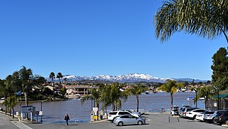
Lake Elsinore is a natural freshwater lake in Riverside County, California, located east of the Santa Ana Mountains and fed by the San Jacinto River. Originally named Laguna Grande by Spanish explorers, it was renamed for the town of Elsinore, now Lake Elsinore, established on its northeastern shore on April 9, 1888.

The San Jacinto River is a 42-mile-long (68 km) river in Riverside County, California. The river's headwaters are in San Bernardino National Forest, but the lower portion of the 765-square-mile (1,980 km2) watershed is urban and agricultural land. As a partially endorheic watershed that is contiguous with other Great Basin watersheds, the western side of the San Jacinto Basin is a portion of the Great Basin Divide.
Horno Creek is a creek that empties into the Pacific Ocean through Horno Canyon on the coast of northern San Diego County on the Marine Corps Base Camp Pendleton. It lies south of Foley Creek and north of Las Flores Creek.
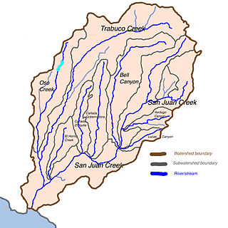
San Juan Creek is a creek in Orange County in the U.S. state of California. It is about 29 miles (47 km) long, and along with its major tributary, Trabuco Creek, drains 133 square miles (340 km2) near the southernmost extent of Orange County. This article describes the course of San Juan Creek.

San Mateo Creek is a stream in Southern California in the United States, whose watershed mostly straddles the border of Orange and San Diego Counties. It is about 22 miles (35 km) long, flowing in a generally southwesterly direction. Draining a broad valley bounded by the Santa Ana Mountains and Santa Margarita Mountains, San Mateo Creek is notable for being one of the last unchannelized streams in Southern California.

Temescal Creek is an approximately 29-mile-long (47 km) watercourse in Riverside County, in the U.S. state of California. Flowing primarily in a northwestern direction, it connects Lake Elsinore with the Santa Ana River. It drains the eastern slopes of the Santa Ana Mountains on its left and on its right the western slopes of the Temescal Mountains along its length. With a drainage basin of about 1,000 square miles (2,600 km2), it is the largest tributary of the Santa Ana River, hydrologically connecting the 720-square-mile (1,900 km2) San Jacinto River and Lake Elsinore watersheds to the rest of the Santa Ana watershed. However, flowing through an arid rain shadow zone of the Santa Ana Mountains, and with diversion of ground water for human use, the creek today is ephemeral for most of its length, except for runoff from housing developments and agricultural return flows.
Coleman Creek in San Diego County, California is a tributary of the San Diego River that arises at the top of the valley running southeasterly from Julian, at a saddle between two ridges of the Cuyamaca Mountains just south of Kentwood-In-The-Pines. From there, Coleman Creek descends northwesterly down the valley to Julian, where it turns west, descending its canyon northwesterly through the site of Branson City, past the mouth of its tributary Eastwood Creek on the north, passing through the south end of Spencer Valley, past the mouth of its tributary Baily Creek on the north, then descending northwest down Quanai Canyon to its confluence with the San Diego River.
Eastwood Creek in San Diego County, California is a tributary of Coleman Creek that arises in the Cuyamaca Mountains, at the north face of the gold bearing mountain north of Julian. From the source Eastwood Creek descends northwesterly a short distance, then turns southwest down a canyon to its confluence with Coleman Creek, just below the site of Branson City.

San Mateo Peak is the unofficially named 3,591-foot (1,095 m) peak, at the western end of the ridge running west then northwest from Elsinore Peak to Morrell Canyon, south and west of the Morrell Potrero in the Elsinore Mountains of the Santa Ana Mountain Range. The peak name was given by Sierra Club Lower Peaks Committee Guide, originally named by Ken Croker who for 20 years maintained trails in the Santa Ana Mountains with volunteers from the Sierra Club. It remains officially nameless despite being the highest summit in the Elsinore Mountains, higher than Elsinore Peak, at 3536 ft., the highest named peak in those mountains.
Carbondale, in Orange County, California, is a historical coal mining town in Santiago Canyon, where Santiago Creek had its confluence with Silverado Creek. It had a post office from May 11, 1881, to January 29, 1884, when it was closed and mail sent to the Santa Ana post office.
Elsinore Mountains, a ridge of mountains within the larger range of the Santa Ana Mountains, in the Cleveland National Forest, Riverside County, California, United States. the tallest peaks within the range is the unofficially named San Mateo Peak at 3,591 ft (1,095 m). Second is officially named Elsinore Peak at 3,536 ft (1,078 m). The Elsinore Mountanins run in a ridge from just east of El Cariso, southeast to Elsinore Peak. Beyond that peak the ridge begins to descend and curves to the east. From Elsinore Peak, a ridge runs to the west and then northwest to San Mateo Peak, enclosing the Morrell Potrero on the south and west.
Morrell Potrero is a flat located in the Cleveland National Forest in Riverside County, California. It has an elevation of approximately 3,041 ft (927 m) in the Elsinore Mountains northwest of Elsinore Peak. It is drained by Morrell Canyon Creek, a tributary of San Juan Creek.

Rancho Capistrano, is a private, gated community surrounded by the Cleveland National Forest, in Riverside County, California.

Los Alamos Canyon Creek, a stream or arroyo, tributary to San Mateo Creek, in the Cleveland National Forest in Riverside County, California. Its source is at an altitude of 2300 feet, in a canyon on the south face of the ridge of Elsinore Mountains that descends to the southeast from Elsinore Peak. The creek descends southward for a short distance then turns southwest for 4 miles where it turns west for 3 miles down Los Alamos Canyon to its confluence with San Mateo Creek at an elevation of 1312 feet.
Tenaja Canyon Creek, a stream or arroyo, tributary to San Mateo Creek, in the Cleveland National Forest in Riverside County, California. Its source is at an altitude of 1875 feet. The creek has its source at the confluence of arroyos from El Potrero del Tenaja, Redonda Mesa and Squaw Mountain highlands. and it flows northwestward 3 1/2 miles down Tenaja Canyon to its mouth and its confluence near Fishermans Camp, at an elevation of 1112 feet with San Mateo Creek.
Devil Canyon Creek, a stream or arroyo, tributary to San Mateo Creek, in the Santa Margarita Mountains, all but its first and last part within the Cleveland National Forest in San Diego County, California. Its source is at an altitude of 2440 feet on a flat private land in the Santa Margarita Mountains. and it flows southwestward then turns down into the canyon and the San Mateo Wilderness and northward 2 miles before turning westward toward its confluence in San Mateo Canyon with San Mateo Creek at an elevation of 453 feet. The last half mile of the creek before this confluence is outside the National Forest boundary, and within the Camp Pendleton Marine Corps Base. Devil Canyon has one named tributary, Cold Spring Canyon Creek, draining the Santa Margarita Mountains north of the Devil Canyon watershed that enters it from the right about a mile and half above the confluence of Devil Canyon Creek with San Mateo Creek.
Cristianitos Canyon Creek, a stream or arroyo, tributary to San Mateo Creek, in the Santa Ana Mountains. its source is within Orange County, California. Its source is at an altitude of 800 feet, at the head of Cristianitos Canyon, in the foothills of the Santa Ana Mountains, in Orange County. It flows southwestward down Cristianitos Canyon, then turns south towards its confluence with San Mateo Creek, at an elevation of 75 feet, in San Diego County.
Temescal Mountains, formerly the Sierra Temescal, are one of the northernmost mountain ranges of the Peninsular Ranges in western Riverside County, in Southern California in the United States. They extend for approximately 25 mi (40 km) southeast of the Santa Ana River east of the Elsinore Fault Zone to the Temecula Basin and form the western edge of the Perris Block.
Cajalco Canyon Creek is an ephemeral stream that flows through Cajalco Canyon in the Temescal Mountains of Riverside County, California, United States. It is a tributary to Temescal Wash, itself a tributary to the Santa Ana River. Cajalco is thought to be a Hispanic spelling of the word for "quail" in the languages of the Luiseño and Cahuilla who lived in the area.


