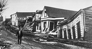
The 1960 Valdivia earthquake and tsunami or the Great Chilean earthquake on 22 May 1960 was the most powerful earthquake ever recorded. Various studies have placed it at 9.4–9.6 on the moment magnitude scale. It occurred in the afternoon, and lasted for approximately 10 minutes. The resulting tsunamis affected southern Chile, Hawaii, Japan, the Philippines, eastern New Zealand, southeast Australia, and the Aleutian Islands.

Castillo San Felipe del Morro, also known as El Morro, is a citadel built between 16th and 18th centuries in San Juan, Puerto Rico.
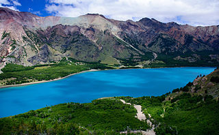
The Aysén del General Carlos Ibáñez del Campo Region, often shortened to Aysén Region or Aisén, is one of Chile's 16 first order administrative divisions. Although the third largest in area, the region is Chile's most sparsely populated region with a population of 102,317 as of 2017. The capital of the region is Coihaique, the region's former namesake.

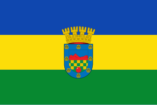
Lo Barnechea is a commune located in the northeastern sector of the province of Santiago and its area corresponds to 48% of this province. Its urban boundaries are: to the north with Los Andes of the Valparaíso region, to the west with Colina, to the southwest with Vitacura and Huechuraba, to the south with Las Condes and to the east with San José de Maipo. It developed around the old rural town of Lo Barnechea. Its population is heterogeneous, as it is inhabited by high and medium-high income families in sectors such as La Dehesa, Los Trapenses and El Arrayán, and also by medium-low and low income families, mainly in the town of Lo Barnechea, Población La Ermita and Cerro Dieciocho.

Arica is a commune and a port city with a population of 222,619 in the Arica Province of northern Chile's Arica y Parinacota Region. It is Chile's northernmost city, being located only 18 km (11 mi) south of the border with Peru. The city is the capital of both the Arica Province and the Arica and Parinacota Region. Arica is located at the bend of South America's western coast known as the Arica Bend or Arica Elbow. At the location of the city are two valleys that dissect the Atacama Desert converge: Azapa and Lluta. These valleys provide citrus and olives for export.
Quilicura is a commune of Chile located in capital Santiago. Founded in 1901, it was originally a satellite city on what were then the outskirts of the city of Santiago, but as urban sprawl has set in it is now quickly urbanizing from what was recently prime agricultural land.
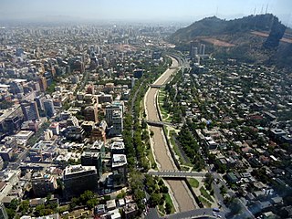
Providencia is a commune of Chile located in Santiago Province, Santiago Metropolitan Region. Part of Greater Santiago, it is bordered by the communes of Santiago to the west, Recoleta to the northwest, Las Condes and Vitacura to the northeast, La Reina to the east, and Ñuñoa to the south. It belongs to the Northeastern zone of Santiago de Chile. Providencia is home to a large upper middle to upper-class population and it holds the region's highest percentage of population over 60 (22%). It contains many high-rise apartment buildings as well as a significant portion of Santiago's commerce. It is notable for its large, old and elegant houses inhabited in the past by the Santiago elite and now mostly used as offices. The municipality is also home to many embassies, including those of Canada, Poland, Hungary, Italy, France, Egypt, Russia, Japan, China, and Uruguay. Providencia has one of the highest human development indexes of any city in Latin America.
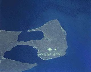
The Valdes Peninsula is a peninsula into the Atlantic Ocean in the Biedma Department of north-east Chubut Province, Argentina. Around 3,625 km2 in size, it is an important nature reserve which was listed as a World Heritage Site by UNESCO in 1999.

Corral is a town, commune and sea port in Valdivia Province, Los Ríos Region, Chile. It is located south of Corral Bay. Corral is best known for the forts of Corral Bay, a system of defensive batteries and forts made to protect Valdivia during colonial times. Corral was the headquarters of the system. Economic activities in Corral revolve around forestry, aquaculture, fishing, port services and both heritage and eco tourism.

The Chilean Coastal Range is a mountain range that runs from north to south along the Pacific coast of South America parallel to the Andean Mountains, extending from Morro de Arica in the north to Taitao Peninsula, where it ends at the Chile Triple Junction, in the south. The range has a strong influence on the climate of Chile since it produces a rain shadow to the east. Because of this the vegetation growing on the seaward slopes is much more exuberant than in the interior. Compared to the coastal lowlands and the Intermediate Depression, it is sparsely populated with land use varying from protected areas to grazing and silviculture. The range is present in all Chilean regions, except for Coquimbo Region and Magallanes Region.

Corral Bay is a bay in the mouth of the Valdivia River, southern Chile. Its main towns are Corral and Niebla. The mouth of the bay is between Juan Latorre point and Morro Gonzalo, with a width of 5.5 km. All the year the bay is transited by merchant, transport and fish boats. The bay is famous for being one of the most fortified bays in Spanish America in colonial time.
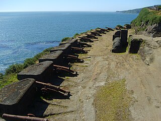
The Fort System of Valdivia is a series of Spanish colonial fortifications at Corral Bay, Valdivia and Cruces River established to protect the city of Valdivia, in southern Chile. During the period of Spanish rule (1645–1820), it was one of the biggest systems of fortification in the Americas. It was also a major supply source for Spanish ships that crossed the Strait of Magellan.
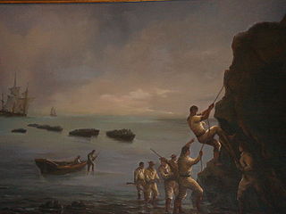
The Capture of Valdivia was a battle in the Chilean War of Independence between Royalist forces commanded by Colonel Manuel Montoya and Fausto del Hoyo and the Patriot forces under the command of Thomas Cochrane and Jorge Beauchef, held on 3 and 4 February 1820. The battle was fought over the control of the city Valdivia and its strategic and heavily fortified harbour. In the battle Patriots gained control of the southwestern part of the Valdivian Fort System after an audacious assault aided by deception and the darkness of the night. The following day the demoralised Spanish evacuated the remaining forts, looted local Patriot property in Valdivia and withdrew to Osorno and Chiloé. Thereafter, Patriot mobs looted the property of local Royalists until the Patriot army arrived to the city restoring order.

Melinka is a Chilean town in Aysén Province, Aysén Region. It is located on Ascención Island and is the administrative center of the commune of Guaitecas since 1979.
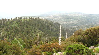
Alerce Costero National Park is a protected wild area in the Cordillera Pelada about 137 km from Valdivia and 49 km from La Unión. Fitzroya trees grow inside the protected area and give the area its name, with Alerce Costero translating as Coastal Fitzroya. The Natural Monument has a total area of 137 hectares.
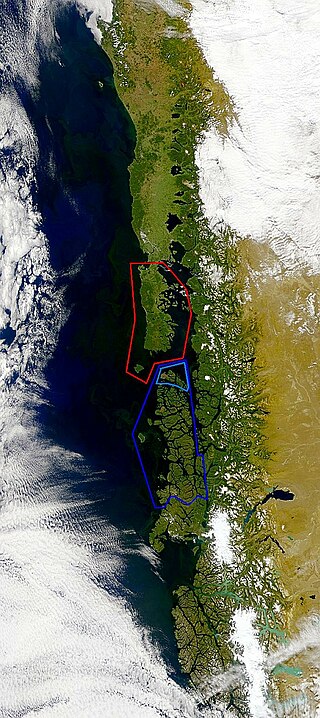
Guaitecas Archipelago is a sparsely populated archipelago in the Aisén region of Chile. The archipelago is made up of eight main islands and numerous smaller ones. The eight largest islands are from northwest to southeast: Gran Guaiteca, Ascención, Betecoy, Clotilde, Leucayec, Elvira, Sánchez and Mulchey. The islands have subdued topography compared to the Andes, with Gran Guaiteca containing the archipelago's high point at 369 m (1,211 ft).

The Battle of San Juan, also known as the Battle of San Juan and Chorrillos, was the first of two battles in the Lima Campaign during the War of the Pacific, and was fought on 13 January 1881. This battle is really a group of smaller, yet fierce confrontations at the defensive strongholds of Villa, Chorrillos, Santiago de Surco, San Juan de Miraflores, Santa Teresa and Morro Solar. The Chilean army led by Gen. Manuel Baquedano inflicted a harsh defeat on the Peruvian army commanded by the Supreme Chief Nicolás de Piérola. The Chilean triumph eliminated the first defensive line guarding Lima, and almost obliterated the Peruvian army defending it.

Tornagaleones River is a river and eastuarine channel in Los Ríos Region, Chile. Together with Valdivia and Futa River it encloses the fluvial island of Isla del Rey. The fresh waters of Tornagaleones comes from Futa, Naguilán and Valdivia River. During high tide brackish waters from Corral Bay enters the channel.
The Chilenization of Tacna, Arica, and Tarapacá was a process of forced transculturation or acculturation in the areas which were invaded and incorporated by Chile since the War of the Pacific (1879–1883). The aim of the Chilenization was to create a dominance of Chilean traditions and culture in that region, in preference to those of the Peruvian population. The British desire to reunite all saltpeter mines under one political administration was also a major factor that influenced the outcome of the war.
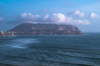
Morro Solar is a headland, situated in the district of Chorrillos, to the south of Lima, Peru. Morro Solar is notable for being a site of the Battle of San Juan and Chorrillos between Peruvian and Chilean forces in 1881. Notable landmarks include an astronomical observatory and a monument to an unknown soldier. Its geological formations are rich in silver which is being extracted by several mining companies.
