Related Research Articles

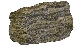
Gneiss is a common and widely distributed type of metamorphic rock. It is formed by high-temperature and high-pressure metamorphic processes acting on formations composed of igneous or sedimentary rocks. Gneiss forms at higher temperatures and pressures than schist. Gneiss nearly always shows a banded texture characterized by alternating darker and lighter colored bands and without a distinct cleavage.

Granulites are a class of high-grade metamorphic rocks of the granulite facies that have experienced high-temperature and moderate-pressure metamorphism. They are medium to coarse–grained and mainly composed of feldspars sometimes associated with quartz and anhydrous ferromagnesian minerals, with granoblastic texture and gneissose to massive structure. They are of particular interest to geologists because many granulites represent samples of the deep continental crust. Some granulites experienced decompression from deep in the Earth to shallower crustal levels at high temperature; others cooled while remaining at depth in the Earth.

The Acasta Gneiss is a tonalite gneiss in the Slave craton in the Northwest Territories, Canada. The rock body is exposed on an island about 300 kilometres north of Yellowknife. The rock of the outcrop was metamorphosed 3.58 to 4.031 billion years ago and is one of the oldest known intact crustal fragments on Earth.

The Narryer Gneiss Terrane is a geological complex in Western Australia that is composed of a tectonically interleaved and polydeformed mixture of granite, mafic intrusions and metasedimentary rocks in excess of 3.3 billion years old, with the majority of the Narryer Gneiss Terrane in excess of 3.6 billion years old. The rocks have experienced multiple metamorphic events at amphibolite or granulite conditions, resulting in often complete destruction of original igneous or sedimentary (protolith) textures. Importantly, it contains the oldest known samples of the Earth's crust: samples of zircon from the Jack Hills portion of the Narryer Gneiss have been radiometrically dated at 4.4 billion years old, although the majority of zircon crystals are about 3.6-3.8 billion years old.

The oldest dated rocks formed on Earth, as an aggregate of minerals that have not been subsequently broken down by erosion or melted, are more than 4 billion years old, formed during the Hadean Eon of Earth's geological history. Meteorites that were formed in other planetary systems can pre-date Earth. Particles from the Murchison meteorite were dated in January 2020 to be 7 billion years old.

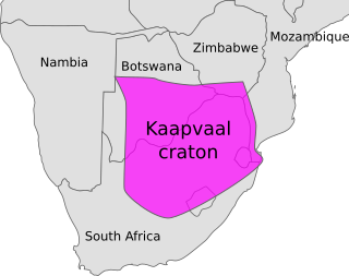
The Kaapvaal Craton, along with the Pilbara Craton of Western Australia, are the only remaining areas of pristine 3.6–2.5 Ga crust on Earth. Similarities of rock records from both these cratons, especially of the overlying late Archean sequences, suggest that they were once part of the Vaalbara supercontinent.

Fall River granite is a Precambrian bedrock underlying the City of Fall River, Massachusetts and surrounding areas along the eastern shores of Narragansett Bay. It was formed 600 million years ago, as part of the Avalon terrane.

Guernsey has a geological history stretching further back into the past than most of Europe. The majority of rock exposures on the Island may be found along the coastlines, with inland exposures scarce and usually highly weathered. There is a broad geological division between the north and south of the Island. The Southern Metamorphic Complex is elevated above the geologically younger, lower lying Northern Igneous Complex. Guernsey has experienced a complex geological evolution with multiple phases of intrusion and deformation recognisable.

The Platteville Limestone is the Ordovician limestone formation in the sedimentary sequence characteristic of the upper Midwestern United States. It is characterized by its gray color, rough texture, and numerous fossils. Its type locality is Platteville, Wisconsin. It was heavily used in the early decades of the building of Minneapolis–Saint Paul and Faribault, Minnesota.
The Piégut-Pluviers Granodiorite is situated at the northwestern edge of the Variscan Massif Central in France. Its cooling age has been determined as 325 ± 14 million years BP.

The Algoman orogeny, known as the Kenoran orogeny in Canada, was an episode of mountain-building (orogeny) during the Late Archean Eon that involved repeated episodes of continental collisions, compressions and subductions. The Superior province and the Minnesota River Valley terrane collided about 2,700 to 2,500 million years ago. The collision folded the Earth's crust and produced enough heat and pressure to metamorphose the rock. Blocks were added to the Superior province along a 1,200 km (750 mi) boundary that stretches from present-day eastern South Dakota into the Lake Huron area. The Algoman orogeny brought the Archean Eon to a close, about 2,500 million years ago; it lasted less than 100 million years and marks a major change in the development of the Earth's crust.
The Great Lakes tectonic zone (GLTZ) is bounded by South Dakota at its tip and heads northeast to south of Duluth, Minnesota, then heads east through northern Wisconsin, Marquette, Michigan, and then trends more northeasterly to skim the northernmost shores of lakes.

Eoarchean geology is the study of the oldest preserved crustal fragments of Earth during the Eoarchean era from 4 to 3.6 billion years ago. Major well-preserved rock units dated Eoarchean are known from three localities, the Isua Greenstone Belt in Southwest Greenland, the Acasta Gneiss in the Slave Craton in Canada, and the Nuvvuagittuq Greenstone Belt in the eastern coast of Hudson Bay in Quebec. From the dating of rocks in these three regions scientists suggest that plate tectonics could go back as early as Eoarchean.

The geology of the Democratic Republic of the Congo is extremely old, on the order of several billion years for many rocks. The country spans the Congo Craton: a stable section of ancient continental crust, deformed and influenced by several different mountain building orogeny events, sedimentation, volcanism and the geologically recent effects of the East Africa Rift System in the east. The country's complicated tectonic past have yielded large deposits of gold, diamonds, coltan and other valuable minerals.
The geology of Mozambique is primarily extremely old Precambrian metamorphic and igneous crystalline basement rock, formed in the Archean and Proterozoic, in some cases more than two billion years ago. Mozambique contains greenstone belts and spans the Zimbabwe Craton, a section of ancient stable crust. The region was impacted by major tectonic events, such as the mountain building Irumide orogeny, Pan-African orogeny and the Snowball Earth glaciation. Large basins that formed in the last half-billion years have filled with extensive continental and marine sedimentary rocks, including rocks of the extensive Karoo Supergroup which exist across Southern Africa. In some cases these units are capped by volcanic rocks. As a result of its complex and ancient geology, Mozambique has deposits of iron, coal, gold, mineral sands, bauxite, copper and other natural resources.

The geology of Sierra Leone is primarily very ancient Precambrian Archean and Proterozoic crystalline igneous and metamorphic basement rock, in many cases more than 2.5 billion years old. Throughout Earth history, Sierra Leone was impacted by major tectonic and climatic events, such as the Leonean, Liberian and Pan-African orogeny mountain building events, the Neoproterozoic Snowball Earth and millions of years of weathering, which has produced thick layers of regolith across much of the country's surface.
The geology of Eswatini formed beginning 3.6 billion years ago, in the Archean Eon of the Precambrian. Eswatini is the only country entirely underlain by the Kaapvaal Craton, one of the oldest pieces of stable continental crust and the only craton regarded as "pristine" by geologists, other than the Yilgarn Craton in Australia. As such, the country has very ancient granite, gneiss and in some cases sedimentary rocks from the Archean into the Proterozoic, overlain by sedimentary rocks and igneous rocks formed during the last 539 million years of the Phanerozoic as part of the Karoo Supergroup. Intensive weathering has created thick zones of saprolite and heavily weathered soils.
The geology of Ukraine is the regional study of rocks, minerals, tectonics, natural resources and groundwater in the country. The oldest rocks in the region are part of the Ukrainian Shield and formed more than 2.5 billion years ago in the Archean eon of the Precambrian. Extensive tectonic evolution and numerous orogeny mountain building events fractured the crust into numerous block, horsts, grabens and depressions and Ukraine was intermittently flooded as the crust downwarped during much of the Paleozoic, Mesozoic and early Cenozoic, before the formation of the Alps and Carpathians defined much of its current topography and tectonics. Ukraine was impacted by the Pleistocene glaciations within the last several hundred thousand years. The country has numerous metal deposits as well as minerals, building stone and high-quality industrial sands.
The Grenville Province is a tectonically complex region, in Eastern Canada, that contains many different aged accreted terranes from various origins. It exists southeast of the Grenville Front and extends from Labrador southwestern to Lake Huron. It is bounded by the St. Lawrence River/Seaway to the southeast.

The Eastern Block of the North China Craton is one of the Earth's oldest pieces of continent. It is separated from the Western Block by the Trans-North China Orogen. It is situated in northeastern China and North Korea. The Block contains rock exposures older than 2.5 billion years. It serves as an ideal place to study how the crust was formed in the past and the related tectonic settings.
References
-
 This article incorporates text from MNopedia, which is licensed under the Creative Commons Attribution-ShareAlike 3.0 Unported License.
- ↑ Aber, James S. (2012). "Morton Gneiss, Minnesota". Emporia State University. Retrieved 2019-05-22.
- 1 2 3 4 5 6 7 8 9 10 11 12 13 14 Nelson, Paul (2018-03-20). "Morton Gneiss". MNopedia. Minnesota Historical Society. Retrieved 2019-05-22.
- ↑ Bickford, M.E.; J.L. Wooden; R.L. Bauer (2006). "SHRIMP study of zircons from Early Archean rocks in the Minnesota River Valley: Implications for the tectonic history of the Superior Province". GSA Bulletin. 118 (1–2): 94–108. Bibcode:2006GSAB..118...94B. doi:10.1130/b25741.1.