Khammam is the city in Khammam district of the Indian state of Telangana. It is the fourth largest city in the state. It is the headquarters of the Khammam district and Khammam mandal also. It is located about 193 kilometres (120 mi) east of the state capital, Hyderabad, 61 kilometres (38 mi) from Suryapet, 120 kilometres (75 mi) from Warangal and also it is located about 121 kilometres (75 mi) North of the Andhra Pradesh state capital, Amaravathi. The river Munneru flows on the western side of the city. As of 2011 census of India, Khammam urban agglomeration has a population of 313,504. However, on 19 October 2012, the civic body of Khammam was upgraded to a municipal corporation. Post- upgradation to corporation, the population of Khammam was approximated to be 3,07,000.

Krishna district is a district in the coastal Andhra Region in Indian state of Andhra Pradesh, with Machilipatnam as its administrative headquarters. It is surrounded on the East by Bay of Bengal, West by Guntur, Bapatla and North by Eluru and NTR districts and South again by Bay of Bengal.

Machilipatnam, also known as Masulipatnam and Bandar, is a city in Krishna district of the Indian state of Andhra Pradesh. It is a municipal corporation and the administrative headquarters of Krishna district. It is also the mandal headquarters of Machilipatnam mandal in Machilipatnam revenue division of the district. The ancient port town served as the settlement of European traders from the 16th century, and it was a major trading port for the Portuguese, British, Dutch and French in the 17th century.

Nuzvid, natively spelled Nuzividu or Nuziveedu is a city in the Eluru district of the Indian state of Andhra Pradesh. It serves as the administrative headquarters for Nuzvid mandal and Nuzvid revenue division.
Pedana is a municipality and the headquarters of Pedana mandal under Machilipatnam revenue division of Krishna district of the Indian state of Andhra Pradesh. It is located at a distance of 8 km (5.0 mi) from the district headquarters, Machilipatnam.
Vuyyuru is a town in Krishna district of the Indian state of Andhra Pradesh. It is a Nagar panchayat and the headquarters of Vuyyuru Mandal. It is emerging as neighbourhood of Vijayawada, India situated 30 km away.
Kankipadu is a suburb of Vijayawada and a in Krishna District of the Indian state of Andhra Pradesh. It is also the mandal headquarters of Kankipadu mandal in Vuyyuru revenue division.
Avanigadda is a town in Krishna district of the Indian state of Andhra Pradesh. It is the mandal headquarters of Avanigadda mandal in Machilipatnam revenue division.

Mylavaram is a town and Suburb of Vijayawada in NTR district of the Indian state of Andhra Pradesh. It is located in Mylavaram mandal of Vijayawada revenue division. Mylavaram town has higher literacy rate compared to Andhra Pradesh. In 2011, literacy rate of Mylavaram village was 69% compared to 67.02% of Andhra Pradesh.

Penuganchiprolu is a village situated in the NTR district of Andhra Pradesh, India. Serving as the mandal headquarters for Penuganchiprolu mandal, it falls under the administration of the Nandigama revenue division. It is situated 71 kilometers northwest of the district headquarters, Vijayawada, and 50 kilometers south of the nearest city, Khammam.
Devarakota is a village in Krishna district of the Indian state of Andhra Pradesh. It is located in Ghantasala mandal of Vijayawada revenue division. The village has been mentioned in the 2015 Mahesh Babu starrer Srimanthudu.
Dokiparru is a village in Gudlavalleru mandal, located in the Krishna district of the Indian state of Andhra Pradesh. Sri Bhusametha Venkateswara Swami Temple is a popular temple in this village, making the village a pilgrimage place.
Doddadevarapadu is a village in Veerullapadu mandal in Krishna District of Andhra Pradesh State, India. It is at the border of Andhra Pradesh and Telangana. It is located 124 km towards west from District headquarters Machilipatnam. Vijayawada, Jaggaiahpet, Nuzvid, are the nearby cities to Doddadevara padu.

Sugguna Lanka is a village in Kollur mandal, located in Guntur district of Andhra Pradesh in India. The name of this village is derived from the Lastname Sugguna.
Vijayawada revenue division is an administrative division in the NTR district of the Indian state of Andhra Pradesh. It is one of the 3 revenue divisions in the district with 8 mandals under its administration. Vijayawada serves as the headquarters of the division. The division has 1 municipality and 1 municipal corporation.
Gampalagudem mandal is one of the 20 mandals in NTR district of the state of Andhra Pradesh in India. It is under the administration of Tiruvuru revenue division and the headquarters are located at Gampalagudem town. The mandal is bounded by Tiruvuru, A. Konduru mandals of NTR district in Andhra Pradesh and Madhira, Yerrupalem mandals in Khammam district of Telangana state.
Chandrala is a village in Krishna district of the Indian state of Andhra Pradesh. It is located in Mylavaram mandal of Vijayawada revenue division. It is one of the villages in the mandal to be a part of Andhra Pradesh Capital Region.
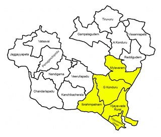
Mylavaram mandal is one of the 20 mandals in the NTR district of the Indian state of Andhra Pradesh. It is under the administration of Vijayawada revenue division and the headquarters are located at Mylavaram town. It is one of mandals of the district located at the boundary of the state. Some of the villages in the mandal are part of the Andhra Pradesh Capital Region under the jurisdiction of APCRDA.
Remidicherla is a small village in Yerrupalem Mandal of Khammam District. It is the second-most populated village in Yerrupalem Mandal.

NTR district is a district in coastal Andhra Region in the Indian state of Andhra Pradesh. The district headquarters is located at Vijayawada. The district is named after former Chief Minister of Andhra Pradesh N. T. Rama Rao. The district shares boundaries with Guntur, Palnadu, Krishna, Eluru, Khammam and Suryapet districts

