
Smolensk is a city and the administrative center of Smolensk Oblast, Russia, located on the Dnieper River, 360 kilometers (220 mi) west-southwest of Moscow. First mentioned in 863, it is one of the oldest cities in Russia. Population: 316,570 (2021 Census).

The Iranian plateau or Persian plateau is a geological feature spanning parts of West Asia, Central Asia, and South Asia. It makes up part of the Eurasian Plate, and is wedged between the Arabian Plate and the Indian Plate. The plateau is situated between the Zagros Mountains to the west, the Caspian Sea and the Köpet Dag to the north, the Armenian Highlands and the Caucasus Mountains to the northwest, the Strait of Hormuz and the Persian Gulf to the south, and the Indian subcontinent to the east.

Moscow Oblast, also known as Podmoskovye, is a federal subject of Russia. With a population of 8,524,665 living in an area of 44,300 square kilometers (17,100 sq mi), it is one of the most densely populated regions in the country and is the second most populous federal subject. The oblast has no official administrative center; its public authorities are located in Moscow and Krasnogorsk, and also across other locations in the oblast.

Smolensk Oblast, informally also called Smolenshchina (Смоленщина), is a federal subject of Russia. Its administrative centre is the city of Smolensk. As of the 2021 Census, its population was 888,421.

The North Wessex Downs National Landscape is located in the English counties of Berkshire, Hampshire, Oxfordshire and Wiltshire. The name North Wessex Downs is not a traditional one, the area covered being better known by various overlapping local names, including the Berkshire Downs, the North Hampshire Downs, the White Horse Hills, the Lambourn Downs, the Marlborough Downs, the Vale of Pewsey and Savernake Forest.
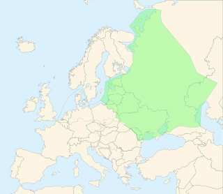
The East European Plain is a vast interior plain extending east of the North European Plain, and comprising several plateaus stretching roughly from 25 degrees longitude eastward. It includes Volhynian-Podolian Upland on its westernmost fringe, the Central Russian Upland, and, on the eastern border, encompasses the Volga Upland. The plain includes also a series of major river basins such as the Dnepr Basin, the Oka–Don Lowland, and the Volga Basin. At the southeastern point of the East European Plain are the Caucasus and Crimean mountain ranges. Together with the North European Plain, and covering the Baltic states, European Russia, Belarus, Ukraine, Moldova, southeastern Romania, and, at its southernmost point, the Danubian Plain in Northern Bulgaria, it constitutes the majority of the Great European Plain, the greatest mountain-free part of the European landscape. The plain spans approximately 4,000,000 km2 (2,000,000 sq mi) and averages about 170 m (560 ft) in elevation. The highest point of the plain, located in the Valdai Hills, is 346.9 metres (1,138.1 ft).

The Wei River is a major river in west-central China's Gansu and Shaanxi provinces. It is the largest tributary of the Yellow River and very important in the early development of Chinese civilization. In ancient times, such as in the Records of the Grand Historian, the river was called Wei Shui.
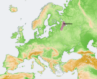
The Valdai Hills, sometimes referred to as just Valdai, are an upland region in the north-west of central European Russia running north–south, about midway between Saint Petersburg and Moscow, spanning the Leningrad, Novgorod, Tver, Pskov, and Smolensk oblasts.

The Belarusian Ridge is a line of terminal moraines, which is almost entirely in the northwest of Belarus. The feature is part of the East European Plain.
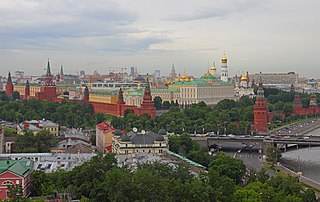
Kremlin Hill is one of the seven hills of Moscow. Altitude up to 145 m. The hill is situated in the city centre, at the confluence of the Moscow River and Neglinnaya River. The Red Square and the upland part of the Kitai-gorod are located on the hill.

The European Plain or the Great European Plain is a plain in Europe and is a major feature of one of four major topographical units of Europe - the Central and Interior Lowlands. It is the largest mountain-free landform in Europe, although a number of highlands are identified within it.

Moscow Governorate was an administrative-territorial unit (guberniya) of the Tsardom of Russia, and the Russian Empire. It bordered by Tver Governorate to the north, Vladimir Governorate to the northeast, Ryazan Governorate to the southeast, Tula Governorate to the south, Kaluga Governorate to the southwest, and Smolensk Governorate to the west. Moscow Governorate consisted of an area of 33,272.84 square kilometres (12,846.72 sq mi) and a population of 2,430,581 in 1897. Its capital was in Moscow.

The Yunnan–Guizhou Plateau or Yungui Plateau is a highland region located in southwest China. The region is primarily spread over the provinces of Yunnan and Guizhou. In the southwest, the Yungui is a true plateau with relatively flatter highland areas, while in the northeast, the Yungui is a generally mountainous area of rolling hills, gorges, and karst topography.
Clear Creek is a southern Illinois watercourse that rises in Jackson County and Union County, and discharges into the Mississippi River in Alexander County.
The Porcupine Hills refer to various groups of hills and uplands located in the prairie provinces of Canada, specifically the provinces of Saskatchewan and Manitoba. They are part of the Manitoba Escarpment, which was the shoreline of the ancient glacial Lake Agassiz. The hills are located north-west of Swan River, Manitoba, and are the headwaters of the Swan River. The highest elevation in the Porcupine Hills is Hart Mountain, at an elevation of 823 metres (2,700 ft), which makes it Manitoba's second-highest point. The Porcupine Provincial Forest surrounds the area.

Odisha is one of the 28 states in the Republic of India. Odisha is located in the eastern part of the Indian peninsula and the Bay of Bengal lies to its East while Chhattisgarh shares its border in the west and north-west. The state also shares geographic boundaries with West Bengal in the north-east, Jharkhand in the north and Andhra Pradesh in the south. The state is spread over an area of 1,55,707 km2 and extends for 700 km from north to south and 500 kilometres from east to west. Its coastline is 450 km long. The state is divided into 30 districts which are further subdivided into 314 blocks.
Alūksne Upland is a hilly area of higher elevation in eastern Latvia, in the historical region of Vidzeme. Sometimes it is referred to as the East Vidzeme Upland, to distinguish it from another hilly area of Vidzeme, Vidzeme Upland, also known as the "Central Vidzeme Upland".

The River Fiddich is a right bank tributary of the River Spey in northeast Scotland. It rises on the eastern slopes of Corriehabbie Hill in Glenfiddich Forest and flows northeastwards beneath the A941 road, past Auchindoun Castle to a sharp bend adjacent to the A920 road where it turns westwards to flow to Dufftown. The Fiddich is joined on the eastern edge of the town by the Dullan Water which drains Glen Rinnes. Their combined waters then flow generally northwestwards, passing beneath the B9014 road near Balvenie Castle and then the A95 at Craigellachie immediately before meeting the Spey.
The Smolensk–Moscow Upland is located in the Yaroslavl, Vladimir, Moscow and Smolensk regions of Russia, as well as the Vitebsk region of Belarus.

The Smolensk Upland is the Western part of the Smolensk–Moscow Upland at the East European Plain, which is located mainly in Smolensk Oblast of Russia, with small parts lying in Moscow and Kaluga Oblasts of Russia and in Vitebsk Region of Belarus. The highest point, located close to the city of Vyazma, is 314 metres (1,030 ft).