Moshulatubbee District

Last updated
Moshulatubbee
Mosholatubbee.jpg

Moshulatubbee District was one of three provinces, or districts, comprising the former Choctaw Nation in the Indian Territory. Also called the First District, it encompassed the northern one-third of the nation. In some historic records it is spelled Mushulatubbe.

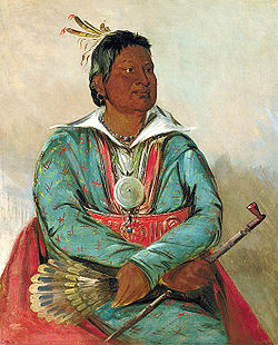
The Moshulatubbee District was named in honor of Chief Moshulatubbee, a Choctaw Indian warrior and statesman. Moshulatubbee was chief of the Okla Tannap ("Lower Towns") District in the original Choctaw Nation of the Southeast. Many Choctaw from that period referred to the Moshulatubbee District as the Okla Tannap District. The other two districts were known as Apukshunnubbee and Pushmataha, also named after important leaders. [1]

History

Moshulatubbee District covered the upper one-third of the Choctaw Nation. Old Choctaw Nation Districts.jpg
Moshulatubbee District covered the upper one-third of the Choctaw Nation.

The districts were established when the Choctaw Nation removed to the Indian Territory. These districts were intended as areas for members of the three major clans, or groupings of Choctaw who comprised the nation. In time, the clan affiliations and allegiances were reduced after the disruption of the move to Indian Territory, in part because of the losses of numerous members in the arduous relocation, called the Trail of Tears. The districts’ importance in the political life of the nation waned, and the district chiefs lost power and authority to the governor (under the 1858 constitution) and later, the principal chief of the nation. Eventually the position of the principal chief became simply, the chief. No longer a "first among equals", he became the sole political leader.

In judicial affairs, the three districts and their seats of government retained their historic influence. Most crimes within the tribal jurisdiction were tried at the county level. If they were of a certain category, they were tried automatically at the district level. Court days were the busiest days of the year in the district seats of government.

Moshulatubbee District’s administrative seat of government was Gaines Court House. This also served as the county seat of Gaines County. The court house was northeast of modern-day McAlester, Oklahoma.

Included in the Moshulatubbee District were the Choctaw counties of Gaines, Sans Bois, Skullyville, Sugar Loaf, and Tobucksy. [2]

As Oklahoma's statehood loomed in the early 20th century, the Moshulatubbee District, and its constituent counties, slowly wound down their governmental functions. The United States Courts in the Indian Territory usurped their powers. On November 16, 1907, Oklahoma’s Statehood Day, the districts and their counties disappeared as active jurisdictions.

The territory of the former Moshulatubbee District is incorporated principally into the present-day Oklahoma counties of Haskell, Hughes, Latimer, Le Flore, and Pittsburg. [3]

Related Research Articles

<span class="mw-page-title-main">Tuskahoma, Oklahoma</span> Unincorporated community and census-designated place in Oklahoma, United States

Tuskahoma is an unincorporated community and census-designated place in northern Pushmataha County, Oklahoma, United States, four miles east of Clayton. It was the former seat of the Choctaw Nation government prior to Oklahoma statehood. The population at the 2010 census was 151.

Apuckshunubbee was one of three principal chiefs of the Choctaw Native American tribe in the early nineteenth century, from before 1800. He led the western or Okla Falaya District of the Choctaw, of which the eastern edge ran roughly southeast from modern Winston County to Lauderdale County, then roughly southwest to Scott County, then roughly south-southeast to the western edge of Perry County. His contemporaries were Pushmataha and Moshulatubbee, who respectively led the southern district Okla Hannali and the north-eastern district Okla Tannap.

Kiamitia County, also known as Kiamichi County, was a political subdivision of the Choctaw Nation, Indian Territory. The county formed part of the nation's Pushmataha District, or Third District, one of three administrative super-regions.

Cedar County was a political subdivision of the Choctaw Nation in the Indian Territory. The county formed part of the nation’s Apukshunnubbee District, or Second District, one of three administrative super-regions.

Jack's Fork County, also known as Jack Fork County, was a political subdivision of the Choctaw Nation of Indian Territory. The county formed part of the nation's Pushmataha District, or Third District, one of three administrative super-regions.

Jackson County was a political subdivision of the Choctaw Nation of Indian Territory, prior to Oklahoma being admitted as a state. The county formed part of the Nation's Pushmataha District, or Third District, one of three administrative super-regions.

Nashoba County was a political subdivision of the Choctaw Nation of Indian Territory. The county formed part of the Nation’s Apukshunnubbee District, or Second District, one of three administrative super-regions in the Nation. This territory was later made part of the state of Oklahoma.

Apukshunnubbee District was one of three provinces, or districts, comprising the former Choctaw Nation in Indian Territory. Also called the Second District, it encompassed the southeastern one-third of the nation.

<span class="mw-page-title-main">Pushmataha District</span>

Pushmataha District was one of three provinces, or districts, comprising the former Choctaw Nation in the Indian Territory. Also called the Third District, it encompassed the southwestern one-third of the nation.

Blue County was a political subdivision of the Choctaw Nation of Indian Territory, prior to Oklahoma being admitted as a state. The county formed part of the Nation’s Pushmataha District, or Third District, one of three administrative super-regions.

Wade County was a political subdivision of the Choctaw Nation of Indian Territory, prior to Oklahoma being admitted as a state. The county formed part of the Nation's Apukshunnubbee District, or First District, one of three administrative super-regions.

<span class="mw-page-title-main">Atoka County, Choctaw Nation</span> Former political subdivision of the Choctaw Nation

Atoka County was a political subdivision of the Choctaw Nation of Indian Territory, prior to Oklahoma being admitted as a state. The county formed part of the Nation's Pushmataha District, or Third District, one of three administrative super-regions.

Towson County was a political subdivision of the Choctaw Nation of Indian Territory, prior to Oklahoma being admitted as a state. The county formed part of the Nation's Apukshunnubbee a District, or Second District, one of three administrative super-regions.

Bok Tuklo County was a political subdivision of the Choctaw Nation of Indian Territory, prior to Oklahoma being admitted as a state. The county formed part of the Nation’s Apukshunnubbee District, or Second District, one of three administrative super-regions.

Red River County was a political subdivision of the Choctaw Nation of Indian Territory, prior to Oklahoma being admitted as a state. The county formed part of the Nation's Apukshunnubbee District, or Second District, one of three administrative super-regions.

Skullyville County was a political subdivision of the Choctaw Nation of Indian Territory, prior to Oklahoma being admitted as a state. The county formed part of the Nation's Moshulatubbee District, or First District, one of three administrative super-regions.

Sans Bois County was a political subdivision of the Choctaw Nation of Indian Territory, prior to Oklahoma being admitted as a state. The county formed part of the Nation's Moshulatubbee District, or First District, one of three administrative super-regions.

Sugar Loaf County was a political subdivision of the Choctaw Nation of Indian Territory, prior to Oklahoma being admitted as a state. The county formed part of the Nation's Moshulatubbee District, or First District, one of three administrative super-regions.

Gaines County was a political subdivision of the Choctaw Nation of Indian Territory, prior to Oklahoma being admitted as a state. The county formed part of the Nation's Moshulatubbee District, or First District, one of three administrative super-regions.

Tobucksy County was a political subdivision of the Choctaw Nation of Indian Territory, prior to Oklahoma becoming a state. It was part of the Moshulatubbee District, or First District, one of three administrative super-regions.

References

  1. Angie Debo, The Rise and Fall of the Choctaw Republic, p. 40.
  2. Angie Debo, The Rise and Fall of the Choctaw Republic, pp. 151-154.
  3. John W. Morris, Historical Atlas of Oklahoma, plate 38.