Mosquito-Grizzly Bear's Head-Lean Man

Last updated

Mosquito-Grizzly Bear's Head, Lean Man is the name of an Assiniboine First Nation reserve in Cando, Saskatchewan, Canada. It is home to a population of about 300.

Assiniboine ethnic group

The Assiniboine or Assiniboin people, also known as the Hohe and known by the endonym Nakota, are a First Nations/Native American people originally from the Northern Great Plains of North America.

In Canada, the First Nations are the predominant indigenous peoples in Canada south of the Arctic Circle. Those in the Arctic area are distinct and known as Inuit. The Métis, another distinct ethnicity, developed after European contact and relations primarily between First Nations people and Europeans. There are 634 recognized First Nations governments or bands spread across Canada, roughly half of which are in the provinces of Ontario and British Columbia.

In Canada, an Indian reserve is specified by the Indian Act as a "tract of land, the legal title to which is vested in Her Majesty, that has been set apart by Her Majesty for the use and benefit of a band."

Contents

Origin of the Name & the Constitution of the Community

Mosquito Grizzly Bears Head Lean Man Assiniboine Nation Treaty 6 and Treaty 4 Circa 1890-8, the tribal chief "Misketo" signed Treaty 6, formally incorporating three tribes that had settled in the area as one reservation (as then legally defined in the British Empire of the Dominion of Canada): [1]

Treaty 6

Treaty 6 is the sixth of seven numbered treaties that were signed by the Canadian Crown and various First Nations between 1871 and 1877. Specifically, Treaty 6 is an agreement between the Crown and the Plains and Woods Cree, Assiniboine, and other band governments at Fort Carlton and Fort Pitt. Key figures, representing the Crown, involved in the negotiations were Alexander Morris, Lieutenant Governor of the North-West Territories; James McKay, The Minister of Agriculture for Manitoba; and W.J. Christie, the Chief Factor of the Hudson's Bay Company. Chief Mistawasis and Chief Ahtahkakoop represented the Carlton Cree.

British Empire States and dominions ruled by the United Kingdom

The British Empire comprised the dominions, colonies, protectorates, mandates and other territories ruled or administered by the United Kingdom and its predecessor states. It originated with the overseas possessions and trading posts established by England between the late 16th and early 18th centuries. At its height, it was the largest empire in history and, for over a century, was the foremost global power. By 1913, the British Empire held sway over 412 million people, 23% of the world population at the time, and by 1920, it covered 35,500,000 km2 (13,700,000 sq mi), 24% of the Earth's total land area. As a result, its political, legal, linguistic and cultural legacy is widespread. At the peak of its power, the phrase "the empire on which the sun never sets" was often used to describe the British Empire, because its expanse around the globe meant that the sun was always shining on at least one of its territories.

Thus, the formal English name now found on maps attempts to incorporate all three communities' names, sometimes with the inconsistent use of either hyphens or commas (or both) between them.

Geography

Mosquito First Nation is an Assiniboine Nation located in the Eagle Hills approximately 30 kilometres (km) south of Battleford, Saskatchewan. It is nearly 50,000 acres in size and boasting over 1000 members (source?).

History

In August 1878, Chief Mosquito signed an adhesion to Treaty 6 at Battleford after taking over the Band from Little Chief. Grizzly Bear's Head originally signed Treaty 4 under Tepee Hoska at Cypress Hills in 1877. The Band migrated to the Battleford area after Tepree Hoska died in 1882. Both Bands merged in 1951.

After signing an adhesion to Treaty 4, Lean Man Band settled in the Treaty 6 area south of Battleford in May 1882. In 1931 the Lean Man Band's population decreased to a membership of one and was then merged with Mosquito Grizzly Bear's Head.

Lean Man

Lean Man took treaty on Sept 25th, 1877 at Fort Walsh (when a number of Assiniboine/Stoney bands took treaty) and the band's annuity payments appeared under Treaty 4, but no reserve lands were set aside for them until 1884. It's important to note the spelling on the official Treaty 4 Adhesion document as the Nakoda words "Wica Hostaka" are written by the X of Lean Man. In the Nakoda/Assiniboine language, 'Wica' means Man and "Hostaka" means Lean. During this period, as was the case with other bands, Lean Man did not take a reserve but continued to move back and forth across the border. In 1882, when Fort Walsh was closed, Lean Man moved north into Treaty 6 territory and were given a reserve along with Grizzly Bear's Head (reserve lands 110 and 111) - this band was therefore listed under Treaty 6 for all future treaty annuity payments. In 1885, the band participate in the 1885 rebellion and their annuities were suspended from 1885 to 1887. Many band members fled to the US along with other "Rebel Indians". They have been considered a Treaty 6 band since 1882.

Grizzly Bear's Head

During the 1877 treaty adhesion meeting at Fort Walsh, some groups were refused permission to sign as they had been receiving annuity payments from the US in Montana. One such band was Little Chief's, a "British" band who had relocated to Montana. As had been the case with other bands, this group moved back and forth across the border, with both the Canadian and American authorities trying to stop the cross-border movement. In 1879, Little Chief's band moved back into Canada and was paid annuity, listed in the Treaty 4 paylist and paid the arrears for 1876 to 1878. There is no indication that Little Chief took a formal adhesion to the treaty. In 1880, Chief Bear's Head is listed as the chief of the band and the band is subsequently listed as "Bear's Head band". In 1882 after the closure of Fort Walsh and as part of the same move as Lean Man, the band relocated northwards to the same reserve as Lean Man's (reserve lands 110 and 111) and was therefore listed under Treaty 6 for all future treaty annuity payments. During the 1885 Rebellion, Grizzly Bear's Head rose up against the Crown. Just like Lean Man, their annuities were suspended between 1885 and 1887. After the Rebellion, the majority of the band fled to the US or dispersed to other bands.

Mosquito

Chief Misketo (also known as Sukeman) signed an adhesion to Treaty 6 on August 29, 1878, and record of their annuity payment appears in the 1878 Treaty 6 paylist. The survey for their reserve lands were conducted in 1879 and were adjacent to those of Red Pheasant in the Eagle Hills (reserve no. 109 - this reserve was surrendered in 1905). The band participated in the 1885 Rebellion against the Crown and their annuities were subsequently suspended between 1885 and 1887. After the Rebellion, a large number of the band fled to the US or dispersed to other bands.

"As long as the grass grows, sun shines and the rivers flow" in 1948 The then Chief and council of the Mosquito Grizzly Bears Head Lean Man band declared that the Three bands remain together for all time, if any band member wished to distinguish the band and separate the bands then that person and his family should leave the band altogether" Chief Jim Spyglass, councillor Joe Wahobin, councillor Adam Mosquito,

Chief Mosquito would remain the Primary Chief of the Three bands of Mosquito, Grizzly Bears Head, Lean Man First Nations. Mosquito Grizzly Bears Head Lean Man Band is regarded as a member of the Treaty Four and Treaty Six areas, and is the only band in Canada with this status. Treaty Four Gatherings in Fort QuAppelle area reserve a place in their Council Meetings for the Mosquito Grizzly Bears Head Lean Man Band to this day.

Related Research Articles

The Cree are one of the largest groups of First Nations in North America.

North-West Rebellion brief and unsuccessful uprising in 1885 by the Métis people under Louis Riel and an associated uprising by First Nations Cree and Assiniboine of the District of Saskatchewan against the government of Canada

The North-West Rebellion of 1885 was a brief and unsuccessful uprising by the Métis people under Louis Riel and an associated uprising by First Nations Cree and Assiniboine of the District of Saskatchewan against the government of Canada. Many Métis felt Canada was not protecting their rights, their land and their survival as a distinct people. Riel had been invited to lead the movement of protest. He turned it into a military action with a heavily religious tone. This alienated Catholic clergy, whites, most Indigenous tribes and some Métis. But he had the allegiance of a couple hundred armed Métis, a smaller number of other Indigenous warriors and at least one white man at Batoche in May 1885, confronting 900 Canadian militia plus some armed local residents. About 91 people would die in the fighting that occurred that spring, before the rebellion's collapse.

Battle of Cut Knife battle

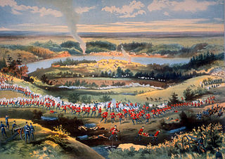
The Battle of Cut Knife, fought on May 2, 1885, occurred when a flying column of mounted police, militia, and Canadian army regular army units attacked a Cree and Assiniboine teepee settlement near Battleford, Saskatchewan. First Nations fighters forced the Canadian forces to retreat, with losses on both sides.

Edgar Dewdney Canadian politician

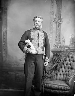
Edgar Dewdney, was a Canadian surveyor, road builder, Indian commissioner and politician born in Devonshire, England. He emigrated to British Columbia in 1859 in order to act as surveyor for the Dewdney Trail that runs through the province. In 1870, Dewdney decided to take up a role in Canadian government. In this year, he was elected to the Legislative Council of British Columbia as a representative form the Kootenay region. In 1872, he was elected as a member of Federal Government for the Yale region representing the Conservative party. He was reelected to this position in 1874 and again in 1878. Dewdney served as Lieutenant Governor of the North-West Territories from 1879 to 1888, and the fifth Lieutenant-Governor of British Columbia from 1892 to 1897. Additionally, he served as the Indian commissioner in the North-West Territories from 1879 until 1888. In 1897, Dewdney retired from politics and began working as a financial agent until his death in 1916.

Piapot chief of the Cree-Assiniboine band of Young Dogs

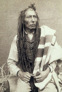
Piapot, Payipwât, or Payipwat, born as Kisikawasan, known by his Assiniboine allies as Maȟpíya owáde hókši was a Native Canadian chief of the Cree-Assiniboine / Young Dogs Band, a mighty band and division of the Downstream People (Māmihkiyiniwak) of the Plains Cree. He was one of the five major leaders of the Plains Cree after 1860.

Pîhtokahanapiwiyin Cree chief

Pîhtokahanapiwiyin, better known as Chief Poundmaker, was a Plains Cree chief known as a peacemaker and defender of his people.

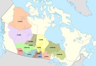
First Nations in Saskatchewan constitute many Native Canadian band governments. First Nations ethnicities in the province include the Cree, Assiniboine, Saulteaux, Dene and Dakota. Historically, the Atsina and Blackfoot could also be found at various times.

Crazy Bear (Assiniboine chief) Native American chief of the Assiniboine tribes

Crazy Bear (1785–1856) was an Indian chief of the Assiniboine tribes of the northern plains. Their territory included Montana, North Dakota, Alberta and Saskatchewan. He is known as a skilled negotiator with the American Fur Company at Fort Union, North Dakota; and for his participation and representation at the Fort Laramie Treaty Council of 1851—where he was a signatory of the treaty' He earned the name Mah-To-Wit-Ko because he fought like a crazy bear. "Wit-Ko" is a Siouan word that has multiple translations: crazy, foolish, frightening and mad. Crazy Bear has been recorded by these names and also in French as Ours Fou.

Frog Lake Massacre

The Frog Lake Massacre was part of the Cree uprising during the North-West Rebellion in western Canada. Led by Wandering Spirit, young Cree men attacked officials, clergy and settlers in the small settlement of Frog Lake in the District of Saskatchewan in the Northwest Territories on 2 April 1885. Nine settlers were killed in the incident.

Treaty 4 agreement between the monarch of Canada and Saulteaux First Nations

Treaty 4 is a treaty established between Queen Victoria and the Cree and Saulteaux First Nation band governments. The area covered by Treaty 4 represents most of current day southern Saskatchewan, plus small portions of what are today western Manitoba and southeastern Alberta. This treaty is also called the "Qu'Appelle Treaty," as its first signings were conducted at Fort Qu'Appelle, North-West Territories, on 15 September 1874. Additional signings or adhesions continued until September 1877. This treaty is the only indigenous treaty in Canada that has a corresponding indigenous interpretation.

Fort Pitt Provincial Park human settlement in "Frenchman Butte No. 501,  Saskatchewan", Saskatchewan, Canada

Fort Pitt was a fort built in 1830 by the Hudson's Bay Company that also served as a trading post on the North Saskatchewan River in Canada. It was built at the direction of Chief Factor John Rowand, previously of Fort Edmonton, in order to trade for bison hides, meat and pemmican. Pemmican, dried buffalo meat, was required as provisions for HBC's northern trading posts.

Fort Walsh building in Saskatchewan, Canada

Fort Walsh is a National Historic Site of Canada that was a North-West Mounted Police (NWMP) fort and the site of the Cypress Hills Massacre. Administered by Parks Canada, it forms a constituent part of Cypress Hills Interprovincial Park.

Ermineskin Cree Nation also known as the Ermineskin Tribe, is a band government in Alberta, Canada, a western branch of the large Cree Nation, and a Treaty 6 nation.

Looting of Battleford

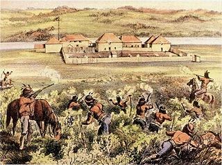
The Looting of Battleford began at the end of March, 1885, during the North-West Rebellion, in the town of Battleford, Saskatchewan, then a part of the Northwest Territories.

Saskatchewan Highway 658 connects Saskatchewan Highway 4 near Red Pheasant Indian Reserve 108 to SK Hwy 4 near Battleford. Highway 658 travels around Mosquito Indian Reserve 109, whereas Highway 4 travels north through the Indian Reserve. To the north of Mosquito Indian Reserve 109 is Grizzly Bear's Head and Lean Man Indian Reserve. The centre of Battleford is 1.5 kilometres (0.93 mi) from the Highway 658 Highway 4 junction. The length of Highway 658 is 41.2 kilometres (25.6 mi).

Treaty Four Reserve Grounds Indian Reserve No. 77 is an Indian Reserve in Saskatchewan, Canada, shared by 33 band governments from Saskatchewan and Manitoba. The Reserve Grounds are located adjacent to and west of Fort Qu'Appelle, Saskatchewan. All bands are signatories to Treaty 4. This Reserve may belong to Assiniboine Chief Long Lodge #77. Who was a treaty signatory chief to treaty 4 in 1877 at Cypress Hills

Carry the Kettle Nakoda First Nation #76 is a Nakota (Assiniboine) First Nation located approximately 80 km (50 mi) east of Regina, Saskatchewan, and 13 km (8.1 mi) south of Sintaluta, Saskatchewan. The reservation is in the Treaty 4 territory.

Lawrence Vankoughnet was an agent with Canada's Department of Indian Affairs in the late 19th century. Vankoughnet moved quickly up the ranks of the DIA, beginning as a clerk with family connections to prime minister John A. Macdonald. From chief civil servant to deputy superintendent, Lawrence accomplished a lot when he was present. After a 3-month sick leave for a "disordered nervous system", he wasted little time picking up where he left off. Vankoughnet was noted by many historians to be the man who cut costs on the rations the government supplied to the reserves. Despite only visiting the reserves once, where he was reluctant to socialize with the chiefs, Vankoughnet announced his change of policy plans in Battleford shortly afterwards: Indians would only be supplied with rations if they were unable to sustain themselves. Vankoughnet’s goals as deputy superintendent of the DIA was to keep costs to a minimum. He thought that so long as they were supplying reserve peoples with rations, they would remain dependent on the government and therefore a significant burden to their expenditures.

References

Mosquito Band Elders: Mary Jane Spyglass, Archie Bugler, William Starchief (2012)

  1. "Archived copy". Archived from the original on 2005-11-25. Retrieved 2011-07-03.

Coordinates: 52°59′44″N107°41′47″W / 52.99556°N 107.69639°W / 52.99556; -107.69639

Geographic coordinate system Coordinate system

A geographic coordinate system is a coordinate system that enables every location on Earth to be specified by a set of numbers, letters or symbols. The coordinates are often chosen such that one of the numbers represents a vertical position and two or three of the numbers represent a horizontal position; alternatively, a geographic position may be expressed in a combined three-dimensional Cartesian vector. A common choice of coordinates is latitude, longitude and elevation. To specify a location on a plane requires a map projection.