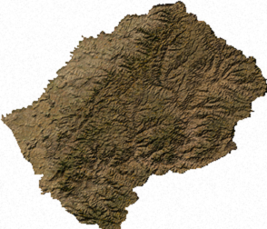
Lesotho is a mountainous, landlocked country located in Southern Africa. It is an enclave, surrounded by South Africa. The total length of the country's borders is 909 kilometres (565 mi). Lesotho covers an area of around 30,355 square kilometres (11,720 sq mi), of which a negligible percentage is covered with water.

Lesotho is geographically surrounded by South Africa and economically integrated with it as well. The economy of Lesotho is based on agriculture, livestock, manufacturing, mining, and depends heavily on inflows of workers’ remittances and receipts from the Southern African Customs Union (SACU). The majority of households subsist on farming. The formal sector employment consist of mainly the female workers in the apparel sector, the male migrant labor, primarily miners in South Africa for 3 to 9 months and employment in the Government of Lesotho (GOL). The western lowlands form the main agricultural zone. Almost 50% of the population earn income through informal crop cultivation or animal husbandry with nearly two-thirds of the country's income coming from the agricultural sector.

Maseru is the capital and largest city of Lesotho. It is also the capital of the Maseru District. Located on the Caledon River, Maseru lies directly on the Lesotho-South Africa border. Maseru is Lesotho's capital city with a population of 330,760 in the 2016 census. The city was established as a police camp and assigned as the capital after the country became a British protectorate in 1869. When the country achieved independence in 1966, Maseru retained its status as capital. The name of the city is a Sesotho word meaning "red sandstones".

South Africa occupies the southern tip of Africa, its coastline stretching more than 2,850 kilometres from the desert border with Namibia on the Atlantic (western) coast southwards around the tip of Africa and then northeast to the border with Mozambique on the Indian Ocean. The low-lying coastal zone is narrow for much of that distance, soon giving way to a mountainous escarpment that separates the coast from the high inland plateau. In some places, notably the province of KwaZulu-Natal in the east, a greater distance separates the coast from the escarpment. Although most of the country is classified as semi-arid, it has considerable variation in climate as well as topography.

The Orange River is the longest river in South Africa and the Orange River Basin extends extensively into Namibia and Botswana to the north. It rises in the Drakensberg mountains in Lesotho, flowing westwards through South Africa to the Atlantic Ocean. The river forms part of the international borders between South Africa and Namibia and between South Africa and Lesotho, as well as several provincial borders within South Africa. Except for Upington, it does not pass through any major cities. The Orange River plays an important role in the South African economy by providing water for irrigation and hydroelectric power. The river was named the Orange River in honour of the Dutch ruling family, the House of Orange, by the Dutch explorer Robert Jacob Gordon. Other names include Gariep River, Groote River or Senqu River.

The Drakensberg is the name given to the eastern portion of the Great Escarpment, which encloses the central Southern African plateau. The Great Escarpment reaches its greatest elevation in this region – 2,000 to 3,482 metres. It is located in South Africa and Lesotho.

Mafeteng is a city in Lesotho, and the Camptown of the district of Mafeteng. It is located about 76 kilometres south of the country's capital, Maseru and has a population of approximately 61,000. The South African border town to Mafeteng is Wepener.

The Highveld is the portion of the South African inland plateau which has an altitude above roughly 1500 m, but below 2100 m, thus excluding the Lesotho mountain regions to the south-east of the Highveld. It is home to some of the country's most important commercial farming areas, as well as its largest concentration of metropolitan centres, especially the Gauteng conurbation, which accommodates one-third of South Africa's population.

Barkly East is a town in Eastern Cape Province, South Africa, seat of the Joe Gqabi District Municipality, and 117 km by road E.S.E. of Aliwal North, lying in the mountainous area just south of Lesotho. The town lies at the southern tip of the Drakensberg on the Langkloofspruit, a tributary of the Kraai River which, in turn is a tributary of the Orange River at an elevation of 1 790 meter above sealevel. Barkly East is characterized by rugged mountains and green valleys. Snow falls in winter, and the hamlet of Rhodes is 60 km or an hour's drive from Barkly East on the R396. Both are within the boundaries of the Senqu Local Municipality. It has been one of the few areas in South Africa where winter sports are pursued, and in summer fly fishing for Rainbow trout and indigenous Smallmouth yellowfish, trail running, mountain biking, ancient rock-art, tennis and the magnificent scenery draw tourists to the district. A more recent development is the mountainous terrain attracting off-road bikers who revel in traversing the numerous passes in the area. Even more recent is the opening of the winter fly fishing season on Wild Trout Association waters around Barkly East, Lady Grey, Rhodes and Wartrail.

Sani Pass is a mountain pass located in the West of KwaZulu-Natal, South Africa on the road between Underberg, KwaZulu-Natal and Mokhotlong, Lesotho.

The Maloti Mountains are a mountain range of the highlands of the Kingdom of Lesotho. They extend for about 100 km into the Free State. The Maloti Range is part of the Drakensberg system that includes ranges across large areas of South Africa. “Maloti” is also the plural for Loti, the currency of the Kingdom of Lesotho. The range forms the northern portion of the boundary between the Butha-Buthe District in Lesotho and South Africa’s Free State.

The Great Escarpment is a major topographical feature in Africa that consists of steep slopes from the high central Southern African plateau downward in the direction of the oceans that surround Southern Africa on three sides. While it lies predominantly within the borders of South Africa, in the east it extends northwards to form the border between Mozambique and Zimbabwe, continuing on beyond the Zambezi River valley to form the Muchinga Escarpment in eastern Zambia. In the west, it continues northwards into Namibia and Angola.

The Mahlasela pass is a tarred pass in the Maloti mountains of Lesotho, reaching a height of 3222 meters. It is one of two passes that links the town of Butha-Buthe with the diamond mining town of Mokhotlong, the other pass being the Moteng pass. Heavy snowfalls frequently closes the pass in winter. The only skiing resort in Lesotho, Afriski is situated here. It is considered to be the highest road pass in Southern Africa.

Rhodes is a hamlet or small village alongside the wild trout rich Bell River, near Ben Macdhui in the Drakensberg mountains of the north Eastern Cape, South Africa.

The Makhaleng River is a river of western Lesotho. It rises in the Maluti Mountains, flows generally in a southwesterly direction to join the Orange River at the border with Free State in South Africa.

Lesotho first participated at the Olympic Games in 1972 and has sent athletes to compete in every Summer Olympic Games since then, except when they boycotted the 1976 Summer Olympics along with most other African nations. Lesotho has never participated in the Winter Olympic Games.

Thaba Bosiu is a sandstone plateau with an area of approximately 2 km2 and a height of 1,804 meters above sea level. It is located between the Orange and Caledon Rivers in the Maseru District of Lesotho, 24 km east of the country's capital Maseru. It was once the capital of Lesotho, having been King Moshoeshoe's stronghold.

Lesotho made its Paralympic Games début at the 2000 Summer Paralympics in Sydney. It has competed in every edition of the Summer Paralympics since then, but never in the Winter Paralympics. Lesotho has never won a medal at the Paralympic Games.


